- Church of St Mary The Virgin, Ston Easton
-
Church of St Mary The Virgin 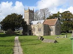
Location: Ston Easton, Somerset, England Coordinates: 51°16′44″N 2°32′27″W / 51.27889°N 2.54083°WCoordinates: 51°16′44″N 2°32′27″W / 51.27889°N 2.54083°W Listed Building – Grade II* Official name: Church of St. Mary The Virgin Designated: 21 September 1960[1] Reference #: 267976 
 Location of Church of St Mary The Virgin in Somerset
The Anglican Church of St Mary The Virgin in Ston Easton, Somerset, England is a Grade II* listed building dating from the 11th century, with a 15th century embattled 3-stage west tower.[1]
The most striking interior feature is the Norman chancel arch, with semi-circular head and colonettes. The pews, choir stalls, altar rails, pulpit, font and screen are all 19th century. There are several 18th and 19th century wall monuments particularly to the Hippisley Coxe family of Ston Easton Park,[1] who have their own chapel at the east end of the north aisle.[2]
The chancel was rebuilt in 1707 and the south aisle around 1800.[2]
The church underwent significant rebuilding in the 19th century, by Arthur Blomfield,[1] which included dismantling most of the building including the Norman arch, marking each stone and then rebuilding them in the same position.[2]
The parish is part of the benefice of Chewton Mendip and the archdeanery of Wells.[3][4]
References
- ^ a b c d "Church of St Mary The Virgin". Images of England. http://www.imagesofengland.org.uk/details/default.aspx?id=267976. Retrieved 23 December 2010.
- ^ a b c Robinson, W.J. (1915). West Country Churches. Bristol: Bristol Times and Mirror Ltd. pp. 164–168.
- ^ "Ston Easton Parish Church". Ston Easton village web site. http://stoneaston.org.uk/village/church. Retrieved 23 December 2010.
- ^ "The Blessed Virgin Mary, Ston Easton". Church of England. http://www.achurchnearyou.com/ston-easton-the-blessed-virgin-mary/. Retrieved 23 December 2010.
Categories:- Church of England churches in Somerset
- 11th-century architecture
- Grade II* listed churches
- Grade II* listed buildings in Somerset


Wikimedia Foundation. 2010.