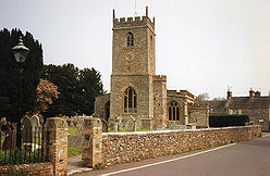
- Church of All Saints, Trull
-
Church of All Saints 
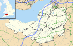
General information Town or city Trull Country England Coordinates 50°59′38″N 3°07′05″W / 50.9938°N 3.1181°W Completed 15th century The Church of All Saints in Trull, Somerset, England has a tower dating from the 13th century; the rest is 15th-century. The building has been designated as a Grade I listed building.[1]
The church was served by the monks of Taunton Priory until 1308.[2]
The east window, dating from the 15th century, depicts the crucifixion with St John and the Mother of Jesus at the foot of the Cross.[3] The pulpit is believed to date from the 16th century, moving to its current position from the north arcade as part of a Victorian restoration around 1863.[4]
The lower portion of the tower is the oldest part of the building, with the north aisle being built in the 14th century and the south aisle in the 15th.[5] The tower holds six bells, two of which were cast before Protestant Reformation.[4]
The parish is part of the benefice of Trull with Angersleigh within the Taunton deanery.[6]
See also
- List of Grade I listed buildings in Taunton Deane
- List of towers in Somerset
References
- ^ "Church of All Saints". Images of England. http://www.imagesofengland.org.uk/details/default.aspx?id=270699. Retrieved 5 December 2007.
- ^ "The History of Trull". Trull village website. http://www.trullvillage.org.uk/history.htm. Retrieved 5 December 2007.
- ^ "Our Church Heritage". Trull parish church. http://www.trullchurch.org.uk/ourchurch.html. Retrieved 5 December 2007.
- ^ a b "Heritage". Trull Church. http://www.trullchurch.org.uk/ourchurch.html. Retrieved 16 November 2011.
- ^ "Trull church". trull Village. http://www.trullvillage.org.uk/church.htm. Retrieved 16 November 2011.
- ^ "All Saints, Trull". Church of England. http://www.achurchnearyou.com/trull-all-saints/. Retrieved 16 November 2011.
Categories:- Church of England churches in Somerset
- 15th-century architecture
- Grade I listed churches
- Grade I listed buildings in Somerset
- Taunton Deane
Wikimedia Foundation. 2010.

