- Church of All Saints, Langport
-
Church of All Saints 
Location: Langport, Somerset, England Coordinates: 51°02′14″N 2°49′32″W / 51.03722°N 2.82556°WCoordinates: 51°02′14″N 2°49′32″W / 51.03722°N 2.82556°W Built: 15th century Listed Building – Grade I Designated: 17 April 1959[1] Reference #: 263185 
 Location of Church of All Saints in Somerset
The Church of All Saints in Langport, Somerset, England, has 12th -century origins but was rebuilt in the late 15th century. It has been designated by English Heritage as a Grade I listed building.[1]
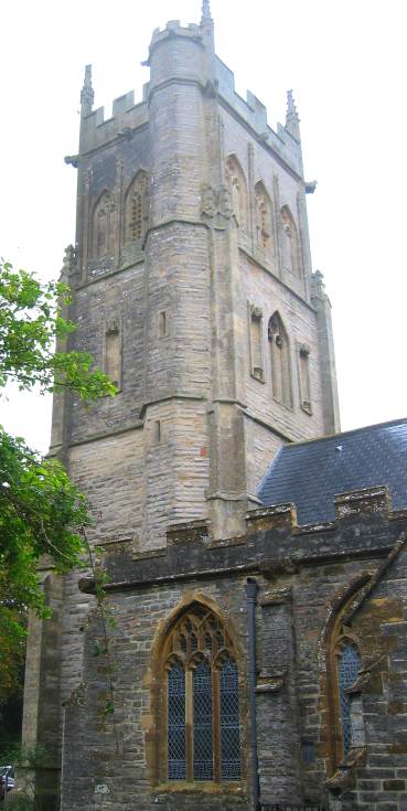
The Perpendicular octagonal tower, which is in three stages, dates from around 1455,[2] but the top section was rebuilt in 1833. It has a number of interesting gargoyles known locally as ‘hunky punks’.[1]
The East window of the chancel contains a set of late 15th century glass depicting various saints, appropriate to the dedication "All Saints". Although restored in the 19th century it is one of the best preserved medieval windows in Somerset. Additionally it is unusual in that the window contains a full set of glass from the same period.
The church is no longer used for services, its congregation has been merged with nearby St Mary's. It is now a redundant church in the care of the Churches Conservation Trust.[3] The church was declared redundant on 1 July 1994, and was vested in the Trust on 28 June 1995.[4] The Trust has carried out extensive rebuilding work.[5]
See also
- List of Grade I listed buildings in South Somerset
- List of towers in Somerset
- List of churches preserved by the Churches Conservation Trust in South West England
References
- ^ a b c "Church of All Saints". Images of England. English Heritage. http://www.imagesofengland.org.uk/Details/Default.aspx?id=263185. Retrieved 2009-06-07.
- ^ Poyntz Wright, Peter (1981). The Parish Church Towers of Somerset, Their construction, craftsmanship and chronology 1350 - 1550. Avebury Publishing Company. ISBN 0861275020.
- ^ All Saints' Church, Langport, Somerset, Churches Conservation Trust, http://www.visitchurches.org.uk/Ourchurches/Completelistofchurches/All-Saints-Church-Langport-Somerset/, retrieved 2 April 2011
- ^ (PDF) Diocese of Bath and Wells: All Schemes, Church Commissioners/Statistics, Church of England, 2011, p. 4, http://www.churchofengland.org/media/810289/bath%20and%20wells%20-%20all%20schemes.pdf, retrieved 2 April 2011
- ^ "The Churches Conservation Trust". The Institute of Historic Building Conservation. http://www.ihbc.org.uk/context_archive/64/cct/cct.html. Retrieved 2008-03-05.
Categories:- Church of England churches in Somerset
- 15th-century architecture
- Grade I listed churches
- Grade I listed buildings in Somerset
- South Somerset
- Churches preserved by the Churches Conservation Trust

Wikimedia Foundation. 2010.