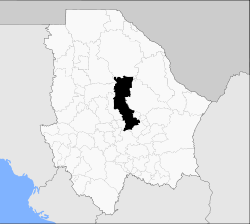
- Chihuahua Municipality
-
Chihuahua — Municipality — Plaza de Armas Municipality of Chihuahua Location in Mexico Coordinates: 28°38′07″N 106°05′20″W / 28.63528°N 106.08889°WCoordinates: 28°38′07″N 106°05′20″W / 28.63528°N 106.08889°W Country  Mexico
State Chihuahua Municipal seat Chihuahua, Chih. Municipality created 7 August 1821 Government – Mayor of Chihuahua Marco Quezada (PRI) Area – Total 9,219.30 km2 (3,559.6 sq mi) Elevation 1,440 m (4,724 ft) Population (2005) – Total 758,791 Postal code 31000 Area code(s) 614 Website http://www.municipiochihuahua.gob.mx Chihuahua is a one of the 67 municipalities of Chihuahua, in northern Mexico. The municipal seat is the city of Chihuahua which is also the capital of Chihuahua State.
As of 2005, the municipality had a total population of 758,791, with 748,551 in the municipal seat. It covers an area of 9219.30 km².
Geography
The municipality includes 375 localities, the population of the principal ones are:
Localidad Población Total Municipio 758,791 Chihuahua 748,518 El Sauz 1,541 Nuevo Delicias 722 San Isidro, Los Hoyos 628 La Casita 333 Nuevo Sacramento 322 Labor de Terrazas 313 Estación Terrazas 306 El Charco 263 Sacramento 229 Colonia Soto 195 Ciénega de Ortiz 53 References
- Municipio de Chihuahua Enciclopedia de los municipios de México, INAFED
 State of Chihuahua
Cities Ciudad Chihuahua • Ciudad Cuauhtémoc • Ciudad Juárez • Delicias • Parral

Municipalities Sights Categories:- Municipalities of Chihuahua
- Chihuahua geography stubs
Wikimedia Foundation. 2010.


