- 1893 Cheniere Caminada hurricane
-
1893 Chenière Caminada Hurricane Category 4 hurricane (SSHS) 
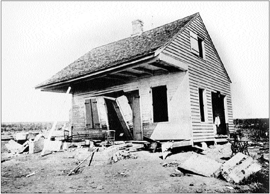
The hurricane wiped the community of Cheniere Caminada off the map, leaving a single, damaged home. Some survivors retreated to what is now Golden Meadow, and others migrated farther inland. Formed September 27, 1893 Dissipated October 5, 1893 Highest winds 1-minute sustained:
135 mph (215 km/h)Lowest pressure 948 mbar (hPa; 27.99 inHg) Fatalities 2000 Damage $5 million (1893 USD) Areas affected Yucatán Peninsula, Louisiana, Mississippi Part of the 1893 Atlantic hurricane season The Chenière Caminada Hurricane, also known as the Great October Storm, was a powerful hurricane that devastated the island of Chenière Caminada, Louisiana in early October 1893. It was one of two deadly hurricanes during the 1893 Atlantic hurricane season; the storm killed an estimated 2,000 people,[1] mostly from storm surge.
Contents
Meteorological history
 Storm path
The hurricane was first observed on September 27, 1893, in the northwest Caribbean Sea. Its previous history is unknown; possibly it formed from a trough of low pressure in the area, a similar method of formation for two other storms this season. The storm moved to the northwest, quickly strengthening into a hurricane on September 28. It continued to intensify to 95 mph winds before hitting near Cancún of the Yucatán Peninsula on the 29th.
While crossing the peninsula, the hurricane weakened to 90 mph, but restrengthened over the warm waters of the Gulf of Mexico. A low pressure trough over the northern Gulf of Mexico brought the hurricane northward and northeastward. On October 1, this compact hurricane became a major hurricane, and early the next day, it became a Category 4 as it approached the Louisiana coast.
On the morning of October 2, with a peak of 135 mph winds, the hurricane struck southeast Louisiana near Chenière Caminada (on the Louisiana mainland just west of Grand Isle). The hurricane continued to the northeast, and weakened while crossing southeast Louisiana. After crossing the northern Gulf of Mexico for a few hours, the hurricane hit on the night of the 2nd, this time on southeast Mississippi. The storm continued to the northeast, weakening to a tropical storm over Alabama, and emerged into the Atlantic Ocean on the 4th. The storm dissipated on the 5th.
Impact
As a strengthening hurricane in the Gulf of Mexico, the Chenière Caminada Hurricane brought a strong storm surge that flooded much of southeast Louisiana. 779 people died out of the town's 1500 residents from the high winds and flooding from the storm surge. The surge was up to 16 feet, with heavy surf above it. The hurricane caused about 2000 fatalities in total, making it among the deadliest American hurricanes.
The Gulf States were greatly affected by the hurricane. The orange and rice crop were greatly damaged, and combined with destruction of the wind, the hurricane caused about $5 million in damage (1893 USD, $102.6 million in 2005 USD).
Name confusion
Various sources give the name of the village as Caminadaville, Chenier Caminada, Cheniere Caminada, or Chenier Caminanda. The island and village were nearly destroyed. Today the town of Cheniere Caminada is located in Jefferson Parish, Louisiana.
See also
References
- ^ Christine Gibson "Our 10 Greatest Natural Disasters," American Heritage, Aug./Sept. 2006.
Further reading
- Davis, Donald W. (1993). "Cheniere Caminada and the Hurricane of 1893". In Magoon, Orville T. et al. (eds.). Coastal Zone ’93. New York: ASCE. pp. 2256–2269. ISBN 0-87262-918-X.
- Falls, Rose C. (1893). Cheniere Caminada or The Wind Of Death: The Story Of The Storm In Louisiana. New Orleans: Hopkins' Printing Office. http://books.google.com/books?id=Ey1ZAAAAMAAJ. Retrieved 2009-07-15. NOTE: The title is incorrectly indexed in Google Books
External links
Categories:- 1893 Atlantic hurricane season
- Category 4 Atlantic hurricanes
- Atlantic hurricanes in Mexico
- Hurricanes in Louisiana
- 1893 in the United States

Wikimedia Foundation. 2010.