- Rotherham Bridge
-
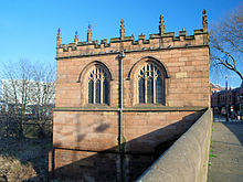 The bridge chapel, seen from the west
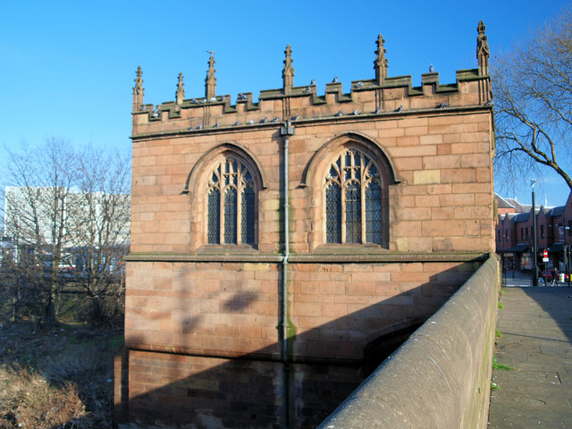
Rotherham Bridge crosses the River Don in central Rotherham, South Yorkshire. It is known for its bridge chapel, considered the best preserved in England.[1]
A document of 1385 refers to Bridgegate in the town, which implies that a previous bridge existed on the same site. The road it carries was originally the main route from London and Mansfield to Barnsley, Halifax and Richmond. The current bridge was erected by 1483, when the Chapel of Our Lady of Rotherham Bridge was added.[1] It is of ashlar sandstone and is built on three piers, each with a cutwater.[2]
John Leland, writing around 1540, described a "fair Stone Bridge of iiii arches" and "a Chapel of Stone well wrought". The chapel was dissolved in 1547 and converted into first an almshouse, then the town gaol and finally a shop.[1] The bridge was altered in 1768–69 by John Platt, working for John Carr of York, but was restored to its original dimensions by Reginald Blomfield in 1927, when Chantry Bridge was built alongside. The chapel was restored at the same time.[2]
The bridge is Grade I listed and is a Scheduled Ancient Monument.[2]
References
- ^ a b c David Hey, Medieval South Yorkshire
- ^ a b c "Rotherham Bridge". Images of England. http://www.imagesofengland.org.uk/Details/Default.aspx?id=335644&mode=adv. Retrieved 2008-01-15.
Coordinates: 53°25′57.5″N 1°21′29.4″W / 53.432639°N 1.358167°W
Categories:- Bridges completed in the 1480s
- Bridges in South Yorkshire
- Buildings and structures in Rotherham
- Grade I listed buildings in South Yorkshire
- Scheduled Ancient Monuments in South Yorkshire
Wikimedia Foundation. 2010.