- Chaa-Kholsky District
-
Chaa-Kholsky District (English)
Чаа-Хольский кожуун (Russian)
Чаа-Хөл кожуун (Tuvan)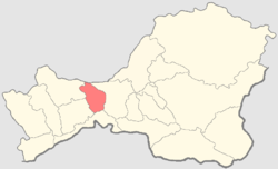
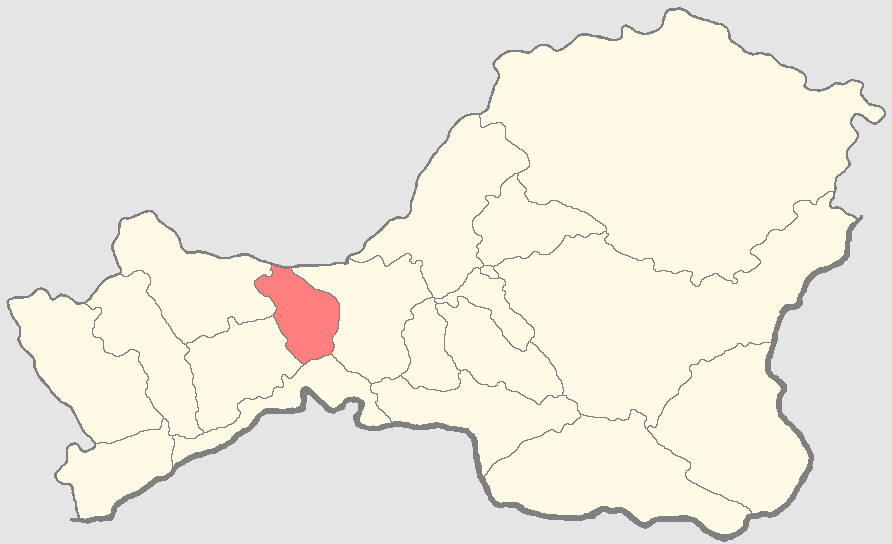
Location of Chaa-Kholsky District on the map of the Republic of TyvaAdministrative status (as of 2009) Country Russia Federal subject Tuva Republic[1] Administrative center selo of Chaa-Khol[2] Statistics Area 2,900 km2 (1,100 sq mi)[3] Population (2010 Census,
preliminary)6,037 inhabitants[4] Population (2002 Census) 6,532 inhabitants[5] - Urban population 0% - Rural population 100% Density 2 /km2 (5.2 /sq mi)[6] Time zone KRAST (UTC+08:00)[7] Established 1992[3] Chaa-Kholsky District (Russian: Чаа-Хольский кожуун; Tuvan: Чаа-Хөл кожуун) is one of the seventeen administrative divisions of the Tuva Republic, Russia. Municipally, it is incorporated as the Municipal District of the Chaa-Kholsky Kozhuun. The area of the district is 2,900 square kilometers (1,100 sq mi).[3] Its administrative center is the rural locality (a selo) of Chaa-Khol.[2] District's population: 6,037 (2010 Census preliminary results);[4] 6,532 (2002 Census).[8] Population of Chaa-Khol accounts for 52.9% of the district's population.[8]
Chaa-Kholsky District was established in 1941.[3] In 1961, the district was abolished and merged with Ulug-Khemsky District.[3] Chaa-Kholsky District was restored in 1992,[3] and in 1994, along with the rest of the districts, it became a kozhuun (raion) according to the new law on the administrative and territorial division of the republic.
References
- ^ Constitution, Article 138.2a
- ^ a b Resolution #1648 ZP-1
- ^ a b c d e f Official website of the Government of the Tuva Republic. Information about Chaa-Kholsky Kozhuun (Russian)
- ^ a b Федеральная служба государственной статистики (Federal State Statistics Service) (2011). "Предварительные итоги Всероссийской переписи населения 2010 года (Preliminary results of the 2010 All-Russian Population Census)" (in Russian). Всероссийская перепись населения 2010 года (All-Russia Population Census of 2010). Federal State Statistics Service. http://www.perepis-2010.ru/results_of_the_census/results-inform.php. Retrieved 2011-04-25.
- ^ Федеральная служба государственной статистики (Federal State Statistics Service) (2004-05-21). "Численность населения России, субъектов Российской Федерации в составе федеральных округов, районов, городских поселений, сельских населённых пунктов – районных центров и сельских населённых пунктов с населением 3 тысячи и более человек (Population of Russia, its federal districts, federal subjects, districts, urban localities, rural localities—administrative centers, and rural localities with population of over 3,000)" (in Russian). Всероссийская перепись населения 2002 года (All-Russia Population Census of 2002). Federal State Statistics Service. http://www.perepis2002.ru/ct/doc/1_TOM_01_04.xls. Retrieved 2010-03-23.
- ^ The value of density was calculated automatically by dividing the 2010 Census population by the area specified in the infobox. Please note that this value may not be accurate as the area specified in the infobox does not necessarily correspond to the area of the entity proper or is reported for the same year as the population.
- ^ Правительство Российской Федерации. Постановление №725 от 31 августа 2011 г. «О составе территорий, образующих каждую часовую зону, и порядке исчисления времени в часовых зонах, а также о признании утратившими силу отдельных Постановлений Правительства Российской Федерации». Вступил в силу по истечении 7 дней после дня официального опубликования. Опубликован: "Российская Газета", №197, 6 сентября 2011 г. (Government of the Russian Federation. Resolution #725 of August 31, 2011 On the Composition of the Territories Included into Each Time Zone and on the Procedures of Timekeeping in the Time Zones, as Well as on Abrogation of Several Resolutions of the Government of the Russian Federation. Effective as of after 7 days following the day of the official publication).
- ^ a b Федеральная служба государственной статистики (Federal State Statistics Service) (2004-05-21). "Численность населения России, субъектов Российской Федерации в составе федеральных округов, районов, городских поселений, сельских населённых пунктов – районных центров и сельских населённых пунктов с населением 3 тысячи и более человек (Population of Russia, its federal districts, federal subjects, districts, urban localities, rural localities—administrative centers, and rural localities with population of over 3,000)" (in Russian). Всероссийская перепись населения 2002 года (All-Russia Population Census of 2002). Federal State Statistics Service. http://www.perepis2002.ru/ct/doc/1_TOM_01_04.xls. Retrieved 2010-03-23.
Sources
- 6 мая 2001 г. «Конституция Республики Тыва», в ред. Конституционного закона №1419 ВХ-2 от 10 июля 2009 г «О внесении изменений в статью 113 Конституции Республики Тыва». Вступил в силу со дня официального опубликования. Опубликован: "Тувинская правда", 15 мая 2001 г. (May 6, 2001 Constitution of the Tyva Republic, as amended by the Constitutional Law #1419 VKh-2 of July 10, 2009 On Amending Article 113 of the Constitution of the Tyva Republic. Effective as of the official publication date).
- Законодательная палата Великого Хурала Республики Тыва. Постановление №1648 ЗП-1 от 21 декабря 2005 г. «Об утверждении реестра административно-территориального деления Республики Тыва», в ред. Постановления №455 ЗП-2 от 21 ноября 2007 г «О внесении изменения в реестр административно-территориального деления Республики Тыва». Вступил в силу 21 декабря 2005 г. Опубликован: "Тувинская правда", №2, 12 января 2006 г. (Legislative Chamber of the Great Khural of the Tyva Republic. Resolution #1648 ZP-1 of December 21, 2005 On Establishing the Registry of the Administrative-Territorial Division of the Tyva Republic, as amended by the Resolution #455 ZP-2 of November 21, 2007 On Amending the Registry of the Administrative-Territorial Division of the Tyva Republic. Effective as of December 21, 2005).
Administrative divisions of the Tuva Republic Capital: Kyzyl
Cities and towns 
Kozhuuns
(administrative districts)Barun-Khemchiksky · Bay-Tayginsky · Chaa-Kholsky · Chedi-Kholsky · Dzun-Khemchiksky · Erzinsky · Kaa-Khemsky · Kyzylsky · Mongun-Tayginsky · Ovyursky · Piy-Khemsky · Sut-Kholsky · Tandinsky · Tere-Kholsky · Tes-Khemsky · Todzhinsky · Ulug-KhemskyCategories:- Districts of Tuva
- States and territories established in 1941
- States and territories disestablished in 1961
- States and territories established in 1992
Wikimedia Foundation. 2010.