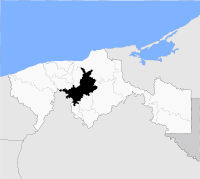
- Centro Municipality
-
The Municipality of Centro is one of the 17 subdivisions of the Mexican state of Tabasco. Its municipal seat is located in the city of Villahermosa. The municipality had a 2010 census population of 640,359 inhabitants, 353,577 (55.2%) of whom lived in its municipal seat, Villahermosa.
The municipal government is headed by the municipal president (mayor) of Centro.
Towns and villages
The municipality has the distinction of having 72 towns (localities) of over 1,000 inhabitants, and 116 towns of over 500 inhabitants, in both cases more than any other municipality in Mexico. The largest localities (cities, towns, and villages) are:[1]
Name 2010 Census Population Villahermosa 353,577 Playas del Rosario (Subteniente García) 21,893 Ocuiltzapotlán 18,312 Parrilla II 10,967 Parrilla 9,964 Tamulté de las Sabanas 8,824 Medellín y Madero Segunda Sección 7,825 Río Viejo Primera Sección 6,726 Macultepec 6,485 Luis Gil Pérez 6,083 Guapinol 5,768 Buena Vista Río Nuevo Segunda Sección 5,740 La Lima 5,638 Buena Vista Río Nuevo Primera Sección 5,627 Medellín y Pigua Tercera Sección 5,520 Ixtacomitán Primera Sección 5,243 Anacleto Canabal Segunda Sección 5,153 Total Municipality 640,359 References
Municipalities
and
(municipal seats)Balancán (Balancán) · Cárdenas (Cárdenas) · Centla (Frontera) · Centro (Villahermosa) · Comalcalco (Comalcalco) · Cunduacán (Cunduacán) · Emiliano Zapata (Emiliano Zapata) · Huimanguillo (Huimanguillo) · Jalapa (Jalapa) · Jalpa de Méndez (Jalpa de Méndez) · Jonuta (Jonuta) · Macuspana (Macuspana) · Nacajuca (Nacajuca) · Paraíso (Paraíso) · Tacotalpa (Tacotalpa) · Teapa (Teapa) · Tenosique (Tenosique de Pino Suárez)

Coordinates: 17°59′21″N 92°55′41″W / 17.98917°N 92.92806°W
Categories:- Municipalities of Tabasco
- Mexico geography stubs
Wikimedia Foundation. 2010.

