'Moteng

'Moteng
'Moteng
—  Community Council  —
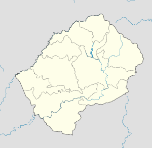
'Moteng is located in Lesotho
'Moteng
Geographic Center of Community
Coordinates: 28°47′00″S 28°29′43″E / 28.7833333°S 28.49528°E / -28.7833333; 28.49528
Country  Lesotho
District Butha-Buthe District
Elevation[1] 7,930 ft (2,417 m)
Population (2006)
 - Total 16,838
Time zone CAT (UTC+2)
Coordinates computed from Lesotho Villages file.[2]

'Moteng is a community council located in the Butha-Buthe District of Lesotho. Its population in 2006 was 16,838.[3]

Villages

The community of 'Moteng includes the villages of Bela-Bela, Boinyatso, Bokong (Khaphamali), Ha Hlakacha, Ha Khanye, Ha Lelala, Ha Lesiba, Ha Machefu, Ha Maieane, Ha Matela, Ha Moiloa, Ha Mokone, Ha Molapo, Ha Molumo, Ha Motapane, Ha Moteoli, Ha Mpotla, Ha Nkota, Ha Phakela, Ha Potomane, Ha Ramahotetsa, Ha Sekete (Paballong), Ha Taetsi, Ha Tlebere, Ha Tsolonyane, Khalikana, Khatleng, Khorong, Khubetsoana, Kolone, Lekhalong, Letsoana, Linotšing, Luma, Machubilane, Maholeng, Makareng, Makeneng, Marabeng, Marati, Maseru (Moteng), Mashapi, Masianokeng, Masoleng, Matebeleng, Mathebe, Mota Rifa, Motahane, Muela, Naleli, Nchekoane, Nyakoaneng, Ordendal, Palehong, Phahameng, Phahleng, Phatlalla, Phelandaba, Phohlane, Phomolong, Pote, Qobella, Sebataolong, Sentelina, Setlakalleng and Thabana-Tšooana.[4]

References

  1. ^ GTOPO30 via GeoNames. Retrieved 2010-07-23.
  2. ^ Google Earth Download Site Retrieved 2010-07-21.
  3. ^ Statoids.com
  4. ^ Lesotho Bureau of Statistics, Village List, 2006.

External links


Wikimedia Foundation. 2010.

Игры ⚽ Поможем написать реферат

Look at other dictionaries:

  • Moteng Pass — Vue du Moteng Pass sous la neige. Altitude 2 820 m Massif Drakensberg …   Wikipédia en Français

  • Moteng Pass — This article is about the mountain pass. For other uses, see Moteng (disambiguation). Moteng Pass Top of Monteng Pass Elevation …   Wikipedia

  • Col Moteng — Moteng Pass Moteng Pass Vue du Moteng Pass sous la neige. Altitude 2 820 m Massif Drakensber …   Wikipédia en Français

  • Geography of Lesotho — Coordinates: 29°30′S 28°30′E / 29.5°S 28.5°E / 29.5; 28.5 …   Wikipedia

  • List of mountain passes — This is a list of mountain passes. Africa *Halfaya Pass *Moteng Pass (Lesotho) *Mahlasela pass (Lesotho)Asia* Khunjerab Pass Pakistan China (highest international border crossing at 4693 m.) * Khyber Pass Pakistan Afghanistan * Kotal e Lataband * …   Wikipedia

  • Butha-Buthe District — Butha Buthe is a district of Lesotho. It has an area of 1,767 km² and a population of approximately 130,000 (2001). Butha Buthe is the capital or camptown, and only town in the district.In the north, Butha Buthe borders on the Free State Province …   Wikipedia

  • Afriski — Afri Ski is currently the only skiing resort in Lesotho , on the Roof of Africa (3322 m above sea level) and in the Heart of Lesotho Maluti mountains , at coord|28.8200|S|28.7300|E|. It s 4½ hours drive from Johannesburg South Africa via the… …   Wikipedia

  • Mahlasela Pass — This article is about the mountain pass. For other uses, see Mahlasela (disambiguation). Mahlasela Pass Elevation …   Wikipedia

  • Butha-Buthe (Distrikt) — Karte Lage des Butha Buthe Distrikts in Lesotho Basisdaten Verwaltungsstadt Butha Buthe Fläche 1.767 km² …   Deutsch Wikipedia

  • Baimasi — Temple du Cheval blanc Pour les articles homonymes, voir Cheval Blanc. Entrée du temple du Cheval blanc …   Wikipédia en Français

Share the article and excerpts

Direct link
Do a right-click on the link above
and select “Copy Link”