- Lâm Đồng Province
Infobox province of Vietnam
Name = Lâm Đồng
Meaning =
Council Chair =
Committee Chair =
Capital = Đà Lạt
Region = Central Highlands
Area = 9,764.8
Population = 1,138,700
Population year = 2004
Population density = 116.61
Ethnicities = Vietnamese, Cơ Ho, , Nùng
Calling code = 63
ISO code = VN-35
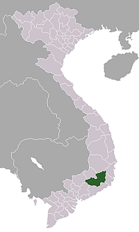
Website = www.lamdong.gov.vnLam Dong (Vietnamese Lâm Đồng audio|Lam Dong.ogg|pronunciation ) is located in the Central Highlands (Tây Nguyên) region of Vietnam. Its capital is Đà Lạt.
Lâm Đồng borders Khánh Hòa and Ninh Thuận to the east, Đồng Nai to the southwest, Bình Thuận to the southeast, and Đắk Lắk to the north. It is the only Central Highlands province which does not share its western border with
Cambodia .Administrative divisions
The province has one city (Đà Lạt), one town (Bảo Lộc), and ten districts:
*Bảo Lâm
*Cát Tiên
*Đạ Huoai
*Đạ Tẻh
*Đam Rông
*Di Linh
*Đơn Dương
*Đức Trọng
*Lạc Dương
*Lâm HàExternal links
* [http://www.dalat.gov.vn/english/geographical.htm Official government website]
Wikimedia Foundation. 2010.