- Mount Lamington
-
Mount Lamington 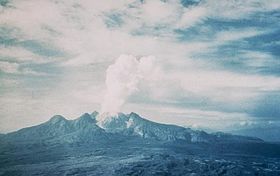
After the devastating 1951 eruptionElevation 1,680 m (5,512 ft) [1] Location Location Oro Province, Papua New Guinea Coordinates 8°57′S 148°09′E / 8.95°S 148.15°ECoordinates: 8°57′S 148°09′E / 8.95°S 148.15°E[1] Geology Type Stratovolcano Last eruption 1956[1] Mount Lamington is an andesitic stratovolcano in the Oro Province of Papua New Guinea. The forested peak of the volcano had not been recognised as such until its devastating eruption in 1951 that caused about 3,000 deaths.[1]
The volcano rises to 1680 m above the coastal plain north of the Owen Stanley Range. A summit complex of lava domes and crater remnants rises above a low-angle base of volcaniclastic deposits that are dissected by radial valleys. A prominent broad "avalanche valley" extends northward from the breached crater.[1]
The mountain was named after Charles Cochrane-Baillie, 2nd Baron Lamington who was Governor of Queensland.[2]
Contents
1951 Eruption
Mount Lamington began to erupt on the night of 18 January 1951. Three days later there was a violent eruption when a large part of the northern side of the mountain was blown away and devastating pyroclastic flows (steam and smoke) poured from the gap for a considerable time afterwards.
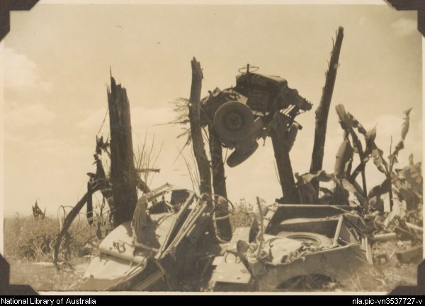
 Devastation caused by the 1951 eruption caused a Jeep to become stuck in a tree
The area of extreme damage extended over a radius of about 12 km, while people near Higaturu, 14 km from the volcano, were killed by the blast or burned to death. The pyroclastic flows and subsequent eruptions of dust and ash which filled streams and tanks, caused the death of some 3,000 persons, and considerable damage.
Rescue parties which arrived on the scene were hampered by suffocating pumice dust and sulphurous fumes, and hot ashes on the ground. The advance post of relief workers at Popondetta was threatened with destruction by other eruptions during the several days following. Further tremors and explosions occurred during February. As late as 5 March a major eruption occurred which threw large pieces of the volcanic dome as far as three kilometres and caused a flow of pumice and rocks for a distance of 14 km, the whole being so hot as to set fire to every tree in its path.
Vulcanologist and former Australian Army Warrant Officer, George Taylor, studied the volcano during the eruption cycle. His work is credited to saving lives by informing rescue parties when it was safe to go into the area. In 1952 he was awarded a George Cross for his efforts.[3]
See also
- List of volcanoes in Papua New Guinea
- List of volcanic eruptions by death toll
References
- ^ a b c d e "Lamington". Global Volcanism Program, Smithsonian Institution. http://www.volcano.si.edu/world/volcano.cfm?vnum=0503-01=.
- ^ Chisholm, Alec Hugh (1958). The Australian Encyclopaedia. Michigan State University Press. p. 225.
- ^ "George Anthony Morgan TAYLOR, GC". George Cross Database Recipient. Archived from the original on 2006-08-25. http://web.archive.org/web/20060825181236/http://www.gc-database.co.uk/recipients/TaylorGAM.htm. Retrieved 2007-01-16.
4. Taylor GA. The 1951 eruption of Mount Lamington, Papua. Bureau of Mineral Resources, Geology and Geophysics, Department of National Development (Australia) 1958; Bulletin 38.
External links
- Collection of photographs and colour slides from the 1951 eruption of Mt Lamington, Papua New Guinea / Albert Speer - held and partially digitised by the National Library of Australia
Categories:- Stratovolcanoes
- Active volcanoes
- Mountains of Papua New Guinea
- Volcanoes of Papua New Guinea
- 1951 natural disasters
- 1951 in Papua New Guinea
- Natural disasters in Papua New Guinea
- Oro Province

Wikimedia Foundation. 2010.