- Missouri Route 18
-
Route 18
Route information Maintained by MoDOT Length: 55.88 mi (89.93 km) Major junctions East end: 

 Route 7/13/52 in Clinton
West end: 359th Street & State Line Road, Kansas state line Highway system Missouri Highways
Supplemental←  Route 17
Route 19  →
→Route 18 is a highway in western Missouri. Its eastern terminus is at the intersection of Route 13/Route 52 and Route 7 in Clinton. Its western terminus is at the Kansas state line near Drexel. It continues into Kansas as a county road.
Route description
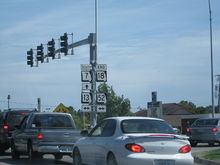 Route 18's eastern terminus at Route 7/13/52 in Clinton.
Route 18 begins at the Kansas state line just west of Drexel. It runs for three miles (5 km) along the Cass/Bates County line. Route 18 then turns south to Merwin, where it turns back east. It then runs through Adrian, Missouri, before having a diamond interchange with the U.S. Route 71 freeway.[1] Route 18 then runs south of Altona and through Ballard. It then runs through Clinton. Route 18 then ends at Routes 7, 13, and 52.
Major intersections
County Location Mile[2] Destinations Notes Bates Drexel 0.00 359th Street & State Line Road Western terminus; Kansas state line Adrian 20.84  US 71
US 71Diamond interchange[1] Henry Clinton 54.69 
Route 13 BUS (2nd Street)55.88 Route 7/Route 13/Route 52Eastern terminus 1.000 mi = 1.609 km; 1.000 km = 0.621 mi References
- ^ a b Google, Inc.. Google Maps (Map). Cartography by NAVTEQ. http://maps.google.com/maps?f=q&hl=en&q=Adrian,+Bates,+Missouri,+United+States&sll=41.89727,-84.03627&sspn=0.12522,0.316544&ie=UTF8&cd=5&geocode=0,38.397450,-94.353100&ll=38.394382,-94.341445&spn=0.008241,0.019784&z=16&om=1.
- ^ DeLorme Street Atlas USA 2007, Toggle Measure Tool
Categories:- State highways in Missouri


Wikimedia Foundation. 2010.