- Utah State Route 101
Infobox road
state=UT
type=SR
route=101
alternate_name=
maint=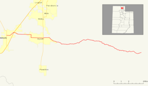
map_notes=
length_mi=21.811
length_ref=cite web|url=http://www.udot.utah.gov/main/uconowner.gf?n=7271625233020881 |title=Route 101|date=November 2005|work= [http://www.udot.utah.gov/main/f?p=100:pg:3977778294530221:::1:T,V:814 Highway Reference] |publisher=Utah Department of Transportation |accessdate=2008-10-04|format=PDF]
length_round=3
established=1931
direction_a=West
terminus_a=jct|state=UT|SR|23 in Wellsville
junction=jct|state=UT|US|89|US|91 in Wellsvillejct|state=UT|SR|165 near Hyrum
direction_b=East
terminus_b=Hardware Ranch trail head
counties=Cache
previous_type=SR
previous_route=100
next_type=SR
next_route=102State Route 101 (SR-101) is a convert|21.811|mi|km|sing=on long
state highway located in theU.S. state ofUtah . The route serves as aspur route into theWasatch-Cache National Forest through the cities of Wellsville and Hyrum, with an intermediate intersection with U.S. Route 89 (US-89) and US-91.Route description
Located entirely in Cache County, SR-101 starts at an intersection of Main Street and SR-23 (Center Street). The highway heads easterly for the first convert|0.4|mi|km|abbr=on|sing=on before it turns northeasterly, crossing the
Little Bear River and intersects US-89/US-91 at atraffic light controlled at-grade interchange. After the interchange, SR-101 turns to the southeast after entering Wellsville city limits. At 400 West, SR-101 turns south for 3 blocks before turning back to the east, and intersecting SR-165.cite map |publisher=Google Maps |title=SR-101 Overview |url=http://maps.google.com/maps?f=d&saddr=41.638699,-111.934462&daddr=Ant+Flat+Rd&hl=en&geocode=%3BFVTKegIdPJxZ-Q&mra=dme&mrcr=0&mrsp=0&sz=15&sll=41.636711,-111.929269&sspn=0.009398,0.030899&ie=UTF8&ll=41.631354,-111.765289&spn=0.150374,0.494385&z=11 |cartography=Tele Atlas |accessdate=2008-10-04]After leaving Hyrum, SR-101 dips to the southeast again, entering the
Wasatch-Cache National Forest and a canyon formed by the Blacksmith Fork River. The final convert|13.9|mi|km|abbr=on are inside the forest, serving as an access route to several campgrounds, as well as adiversion dam , and electric plant. The route comes to an end at theHardware Ranch Wildlife Management Area , a working ranch owned and run by the state of Utah.cite web|url=http://wildlife.utah.gov/hardwareranch/visit.php|title=Visit Hardware Ranch|publisher=Utah Division of Wildlife Resources |accessdate=2008-10-04] cite news|url=http://www.standard.net/xplore/20652/|title=Animal trackers|last=Petersen Jr.|first=Bryce|work=Xplore Outdoors|publisher="Ogden Standard-Examiner "|accessdate=2008-10-04]For the year 2007, a daily average of 5,075 cars traveled along SR-101 at the intersection with US-89/US-91. This represents only a slight growth from previous years (in 2006, the average was 5,005; in 2005, 4,620).cite web|url=http://www.udot.utah.gov/main/uconowner.gf?n=2363711025498494585|format=PDF|title=Traffic on Utah Highways - 2007|date=2008-07-02|publisher=Utah Department of Transportation|pages=|accessdate=2008-10-04] Nineteen percent of this traffic was composed of trucks.cite web|url=http://www.udot.utah.gov/main/uconowner.gf?n=2363733707060508179|format=PDF|title=Truck Traffic on Utah Highways - 2007|date=2008-07-02|publisher=Utah Department of Transportation|pages=|accessdate=2008-10-04] The lowest amount of traffic is accounted for on the final stretch of the highway through the Wasatch-Cache National Forest, with a average of 670 cars per day traveling to the Hardware Ranch visitors center. This represents a small increase from previous years, with an average of 635 cars per day in 2006 and 585 cars per day in 2005 traveling to the visitors center.
History
SR-101 was formed in 1931 as a loop off SR-1 (now US-91) from Logan south to Hyrum and west to Wellsville. [cite UTSR law|year=1931|quote=(101) From Logan southerly via Hyrum to Wellsville.] The road from Hyrum east to the Hardware Ranch was added to the state highway system in 1949 as State Route 242, [cite UTSR law|year=1949|quote="Route 242. From Hyrum on route 101 easterly via Blacksmith Fork approximately 17 miles to the ranch house on the state fish and game property known as the Hardware Ranch."] and that route was extended south to SR-39 in 1965.cite web|url=http://www.udot.utah.gov/main/uconowner.gf?n=200609201008251|title=Route 242|date=November 2007|work= [http://www.udot.utah.gov/main/f?p=100:pg:3977778294530221:::1:T,V:1348 Highway Resolutions] |publisher=Utah Department of Transportation|accessdate=2008-10-04|format=PDF] The legislature redefined the Hyrum-area routes in 1969, taking SR-101 east from Wellsville to the Hardware Ranch over former SR-242, and returning the extension to SR-39 to local control. The leg of former SR-101 from Hyrum north to Logan became part of a new SR-165 at that time. On March 17, 1972, the roadway connecting the Hardware Ranch Visitors Center to SR-101 was added to the state route system as an addition to SR-101. The connector road was previously designated Collector Road 311.cite web|url=http://www.udot.utah.gov/main/uconowner.gf?n=200609181310491|title=Route 101|date=November 2007|work= [http://www.udot.utah.gov/main/f?p=100:pg:3977778294530221:::1:T,V:1348 Highway Resolutions] |publisher=Utah Department of Transportation|accessdate=2008-10-04|format=PDF]
On November 25, 2006, a car failed to turn with a curve on the highway outside of Hyrum and ran off the road into the Blacksmith Fork River. The driver, who was not wearing his
seat belt , was pronounced dead at the nearbyLogan Regional Hospital after emergency crews extracted him from his vehicle. The passenger survived, after escaping the submerged vehicle on their own.cite news|url=http://www.ksl.com/index.php?nid=148&sid=675751|title=Man Dies After Driving Off Road|date=2006-11-26|publisher=KSL-TV |accessdate=2008-10-04]Major intersections
References

Wikimedia Foundation. 2010.