Mary Street, Brisbane

Mary Street, Brisbane
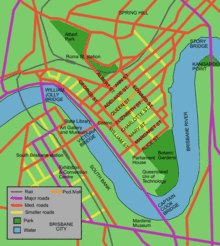
Map of Brisbane City streets

Mary Street is a major road in the Brisbane central business district. The street is one of a number that were named after female queens and princesses of the royal family shortly after the penal colony was settled. Charlotte Street is positioned parallel to the north and Margaret Street runs next to the south.

Mary Street begins in the Government Precinct at a T-intersection with George Street opposite the Executive Building. Also at the elevated southern end is Education House containing state government offices and the Department of Mines and Energy, Queensland are located opposite in the Queensland Minerals & Energy Centre. Felix Tower is located on the corner of Mary and Felix Streets. Waterfront Place and Forestry House are nearby in the lower northern section, close to the river.

Vision Brisbane is a residential skyscraper under construction on Mary Street. It will be the tallest building in the city and state of Queensland.

Mary Street was home to the first premises used by the Queensland Club, before moving to the corner of George Street and Alice Street.[1]

See also

References

  1. ^ Gregory, Helen (2007). Brisbane Then and Now. Wingfield, South Australia: Salamander Books. pp. 34. ISBN 9781741730111. 

Coordinates: 27°28′16.36″S 153°01′42.22″E / 27.4712111°S 153.0283944°E / -27.4712111; 153.0283944


Wikimedia Foundation. 2010.

Игры ⚽ Поможем написать курсовую

Look at other dictionaries:

  • Margaret Street, Brisbane — Map of Brisbane City streets Margaret Street is a major road in the central business district of Brisbane. The street is one of a number that were named after female members of the royal family shortly after the penal colony was settled. Alice… …   Wikipedia

  • Charlotte Street, Brisbane — Map of Brisbane City streets Charlotte Street is a road in the central business district of Brisbane. The street is one of a number that were named after female queens and princesses of the royal family shortly after the penal colony was settled …   Wikipedia

  • William Street, Brisbane — William Street is a small, relatively quiet road in the uptown part of the Brisbane central business district. The street is historical significant to the city s early development as a penal colony. The first convict buildings were built along… …   Wikipedia

  • Brisbane — Saltar a navegación, búsqueda Este artículo trata sobre la ciudad de Brisbane. Para saber más sobre el río, véase Río Brisbane. Brisbane …   Wikipedia Español

  • Brisbane Catholic Education — is the educational Vicariate of the Roman Catholic Archdiocese of Brisbane, Queensland.HistoryThe institution now known as Brisbane Catholic Education had its seed in the first Catholic school in the Archdiocese of Brisbane, started by Mary and… …   Wikipedia

  • Brisbane Arcade — is the name of an art deco shopping arcade located in the city of Brisbane, Queensland, Australia. treet AccessThe arcade can be accessed directly from the Queen Street Mall, and Adelaide Street.OverviewIt is an upmarket shopping destination… …   Wikipedia

  • Mary Maguire — Mary Maguire, c. 1937 Born Hélène Theresa Maguire 22 February 1919(1919 02 22) Melbourne, Victoria, Australia …   Wikipedia

  • Mary Poppins (musical) — Mary Poppins The Original London Poster. Music Robert B. Sherman Richard M. Sherman George Stiles Lyrics Robert B. Sherman Richard M. Sherman …   Wikipedia

  • Mary Kornman — in Dogs of War (1923) Born December 27, 1915(1915 12 27) Idaho Falls, Idaho, U.S. Died …   Wikipedia

  • Brisbane — This article is about the Australian metropolis. For the local government area, see City of Brisbane. For other uses, see Brisbane (disambiguation). Brisbane Queensland …   Wikipedia

Share the article and excerpts

Direct link
Do a right-click on the link above
and select “Copy Link”