- Wasilla Airport
Infobox Airport
name = Wasilla Airport
IATA = WWA
ICAO = PAWS
FAA = IYS
type = Public
owner = City of Wasilla
operator =
city-served =Wasilla, Alaska
location =
elevation-f = 354
elevation-m = 108
coordinates = coord|61|34|19|N|149|32|22|W|region:US_type:airport
website = [http://cityofwasilla.com/index.aspx?page=108 www.CityOfWasilla.com/...]
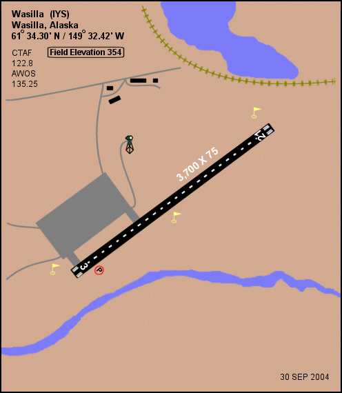
r1-number = 3/21
r1-length-f = 3,700
r1-length-m = 1,128
r1-surface = Asphalt
r2-number = 3S/21S
r2-length-f = 1,690
r2-length-m = 515
r2-surface = Turf/Gravel
stat1-header = Based aircraft
stat1-data = 100
footnotes = Source:Federal Aviation Administration FAA-airport|ID=IYS|use=PU|own=PU|site=50870.3*A, effective 2008-07-31.]Wasilla Airport airport codes|WWA [ASN|WWA] |PAWS [GCM|PAWS] |IYS is a city-owned public-use
airport located threenautical mile s (6 km) west of thecentral business district of Wasilla, a city in the Matanuska-Susitna Borough of theU.S. state ofAlaska . Wasilla is 17 miles by air and 47 miles by road from Anchorage [http://www.cityofwasilla.com/index.aspx?page=108 Airport page at City of Wasilla web site] ] , the largest city in Alaska.Facilities and aircraft
Wasilla Airport has an
asphalt pavedrunway designated 3/21 which measures 3,700 by 75 feet (1,128 x 23 m). It also has a turf andgravel runway (3S/21S) which is 1,690 by 60 feet (515 x 18 m). There are 100 aircraft based at this airport, all single-engine.The airport is open year round and has radio controlled runway, taxiway and security lighting. It offers engine and airframe repair, fuel, and
air-taxi services.References
External links
* [http://wikimapia.org/#lat=61.571521&lon=-149.54092&z=14&l=0&m=a&v=2 Aerial photo of Wasilla Airport]
* [http://www.alaska.faa.gov/fai/images/ARPT_DIAGRAMS/IYS.gifFAA Alaska airport diagram] (GIF )
*
*
Wikimedia Foundation. 2010.