- Nittedal Station
-
Nittedal 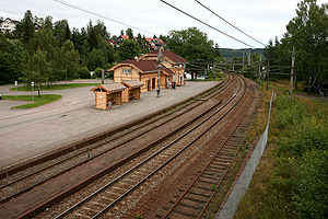
Nittedal Station
Photo: Trond Strandsberg (2007)Location Place Rotnes, Akershus Municipality Nittedal Coordinates 60°3′29″N 10°51′55″E / 60.05806°N 10.86528°ECoordinates: 60°3′29″N 10°51′55″E / 60.05806°N 10.86528°E Line(s) Gjøvikbanen Distance 24.26 km Elevation 235.8 Service Opened 1900 Architect Paul Armin Due Platforms 2 Owner Jernbaneverket Line operator(s) Oslo Commuter Rail Connections Nittedal Station (Norwegian: Nittedal stasjon) is a railway station on Gjøvikbanen at Rotnes in Akershus county, Norway. The station was opened in 1900 as a stop for passengers and freight two years ahead of the opening of Gjøvikbanen in 1902.
In 1907 Nittedal was upgraded from a stop to a station manned to expedite trains, passengers and freight. In the years in between a station building was also erected that had been drawn by architect Paul Armin Due. In 1971, after almost 70 years of being in service the station became fully automatized and remote controlled.
Today the station is unmanned and furnished with ticket machines. It's elevation is 235.8 m AMSL and the distance to Oslo S is 24.26 km.
Sources
- (Norwegian) Norsk Jernbaneklubb.no (Norwegian Railway Association) – page about Nittedal Station
- (Norwegian) Jernbaneverket.no (Norwegian National Rail Administration)– page about Nittedal Station
- (Norwegian) NSB.no – page about Nittedal Station
Preceding station Line Following station Movatn Gjøvikbanen Åneby Preceding station Regional trains Following station Kjelsås Oslo S–Gjøvik Harestua Preceding station Local trains Following station Movatn 300 Skøyen–Oslo S–Jaren Åneby Categories:- Railway stations in Akershus
- Railway stations on Gjøvikbanen
- Railway stations opened in 1900
- Nittedal
- Norwegian railway station stubs

Wikimedia Foundation. 2010.