- New Croton Dam
-
This article is about the dam on the Croton River in New York. For the dam on the Muskegon River in Michigan, see Croton Dam (Michigan).
New Croton Dam 
New Croton DamLocation Cortlandt, Westchester County, New York, USA Coordinates 41°13′35″N 73°51′19″W / 41.22639°N 73.85528°WCoordinates: 41°13′35″N 73°51′19″W / 41.22639°N 73.85528°W[1] Construction began 1892 Opening date 1906 Dam and spillways Height 297 feet (91 m) Length 2,188 feet (667 m) Base width 266 feet (81 m) Reservoir Creates New Croton Reservoir The New Croton Dam, part of the New York City water supply system, stretches across the Croton River near Croton-on-Hudson, New York, about 22 miles (35 km) north of New York City. Construction began in 1892 and was completed in 1906.[2] Designed by Alphonse Fteley (1837–1903), this masonry dam is 266 feet (81 m) broad at its base and 297 feet (91 m) high from base to crest. Its foundation extends 130 feet (40 m) below the bed of the river, and the dam contains 850,000 cubic yards (650,000 m3) of masonry.[3] The engineers' tablet mounted on the headhouse nearest the spillway lists the spillway length as 1,000 feet (300 m) and the total length of the dam and spillway combined as 2,188 feet (667 m).[4] At the time of its completion, it was the tallest dam in the world.[5] New Croton Dam impounds up to 19 billion US gallons (72,000,000 m3) of water, a small fraction of the New York City water system's total storage capacity of 580 billion US gallons (2.2×10⁹ m3).[6]
The dam, in Westchester County, has an unusual spillway, part artificial and part natural, which forms a waterfall on the north side of the structure. New Croton Dam has a public park and trail head at its base and a road along its crest. Road use is limited to pedestrians and emergency vehicles.
History
The original Croton Dam (Old Croton Dam) was built between 1837 and 1842 to improve New York City's water supply. By 1881, after extensive repairs to the dam, which was 50 feet (15 m) high, Old Croton Reservoir was able to supply about 90 million US gallons (340,000 m3) a day to the city via the Old Croton Aqueduct.[7] To meet escalating water needs, the Aqueduct Commission of the City of New York ordered construction of a new Croton system in 1885. Hydro engineer James B. Francis was brought in as a consultant for the construction.[8]
The proposed dam and reservoir were to cover 20 square miles (51.8 km²) of land occupied by public and private buildings, six cemeteries, and more than 400 farms.[2] Condemnation disputes led to "protests, lawsuits, and confusion" before payment of claims and the awarding of construction contracts.[2] The work force on the new dam included stonemasons and laborers who had worked on the original dam. John B. Goldsborough, superintendent of excavations and hiring for the project, also recruited stonemasons from southern Italy, who re-located to New York.
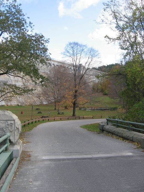
 Old Croton Trail Endpoint
Work began in 1892 at a site four miles (6.4 km) downstream of the original dam, which was submerged by the new reservoir. New Croton Reservoir was eventually able to supply 200 to 300 million US gallons (760,000 to 1,100,000 m3) a day via a new aqueduct that carried water to Jerome Park Reservoir in the north Bronx, New York City.[9]
Building the dam meant diverting the river from its normal path and pumping the riverbed dry. To accomplish this, workers dug a crescent-shaped canal 1,000 feet (300 m) long and 200 feet (61 m) wide in the hill on the north side of the river, secured the canal with a masonry retaining wall, and built temporary dams to control the water flow.[2] The initial construction lasted eight years, and extensive modifications and repairs went on for another six. Working conditions were often difficult. A silent film, The Croton Dam Strike, released in 1900, depicted labor–management problems related to the dam's construction.[10]
The bridge over the spillway was replaced in 1975 and again in 2005. In that same year, because of the September 11 attacks on New York City, the New York City Department of Environmental Protection proposed permanent closure of the road across the top of the dam. Pedestrians and emergency vehicles were allowed to use New Croton Dam Road, but all other traffic was re-routed. The department made plans to replace temporary vehicle barriers with permanent barriers after completion of a New Croton Dam Rehabilitation Project in 2011.[11]
Trails
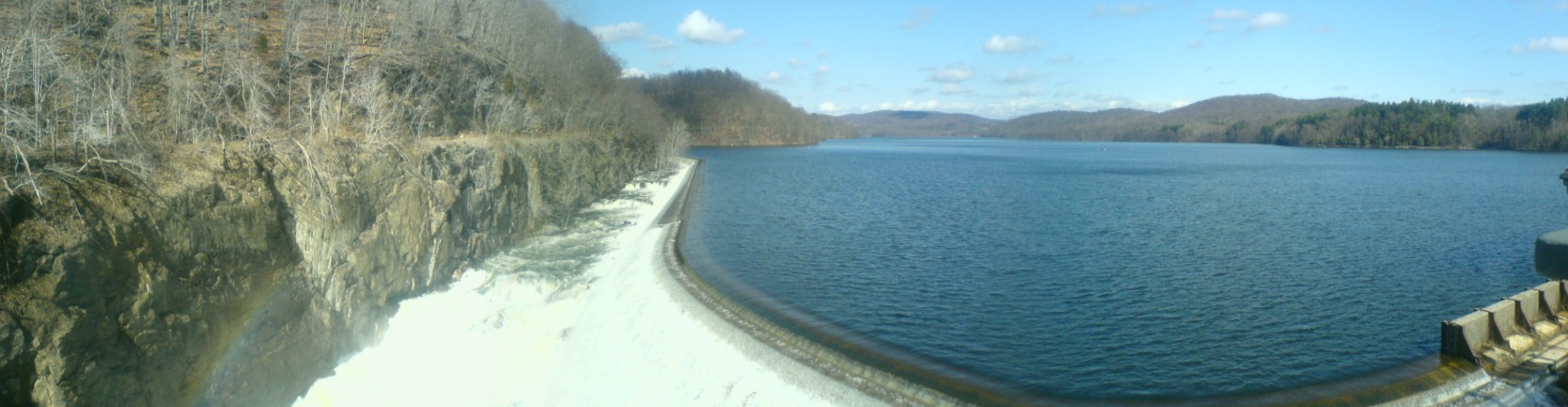
 Panorama view of New Croton Dam, looking northwest
Croton Gorge Park offers views of the dam from directly downstream. The Old Croton Trail, a popular hiking and biking path that roughly follows the route of the Old Croton Aqueduct, has an endpoint near the base of the dam. Teatown Lake Reservation, a nature preserve, lies nearby as does Croton Point Park in Croton-on-Hudson.
References
- ^ "New Croton Dam". Geographic Names Information System (GNIS). United States Geological Survey (USGS). January 23, 1980. http://geonames.usgs.gov/pls/gnispublic/f?p=gnispq:3:::NO::P3_FID:958406. Retrieved October 13, 2008.
- ^ a b c d "The Croton Dam". Village of Croton-on-Hudson Historical Society. Retrieved on July 8, 2007.
- ^ "The Opening of the New Croton Reservoir". Yorktown Historical Society. Retrieved on July 11, 2007.
- ^ Tompkins, Christopher R: The Croton Dams and Aqueduct, page 2. Arcadia Publishing, 2000. ISBN 0-7385-0455-6.
- ^ Jackson, Donald C: Great American Bridges and Dams, page 128. John Wiley and Sons, 1988. ISBN 0-471-14385-5
- ^ "New Croton". New York City Department of Environmental Protection. Retrieved on July 10, 2007.
- ^ "NYC Water Supply Watersheds: History". New York City Department of Environmental Protection. Retrieved on July 11, 2007.
- ^ "Lowell Notes" (PDF). National Park Service. http://www.nps.gov/lowe/historyculture/upload/JB%20Francis_%20Lowell%20Notes.pdf. Retrieved May 12, 2010.
- ^ "History and Geology of the NYC Aqueduct System". Merguerian, Charles. (Notes for October 4, 2000, lecture at the Long Island Geologists Dinner Meeting). Retrieved on July 8, 2007.
- ^ "The Croton Dam Strike". Internet Movie Database. http://www.imdb.com/title/tt0288490/. Retrieved January 11, 2009.
- ^ "New Croton Dam Road Closure Environmental Review". New York City Department of Environmental Protection. January 23, 2007. http://home2.nyc.gov/html/dep/html/environmental_reviews/crotondam.shtml. Retrieved July 11, 2007.
Categories:- Dams in New York
- Croton Watershed
- Buildings and structures in Westchester County, New York

Wikimedia Foundation. 2010.