Dartmouth Range

Dartmouth Range
Dartmouth Range

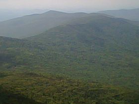
The Dartmouth Range as seen looking west from the first cap of Mount Jefferson, Coos County, New Hampshire
Elevation 1,136 m (3,727 ft)
Location
Location Coos County, New Hampshire, USA
Coordinates 44°18′08″N 71°24′23″W / 44.30222°N 71.40639°W / 44.30222; -71.40639Coordinates: 44°18′08″N 71°24′23″W / 44.30222°N 71.40639°W / 44.30222; -71.40639

The Dartmouth Range is a mountain range in the White Mountains of New Hampshire in the United States. The range lies in the township of Low and Burbank's Grant and the town of Carroll in Coos County.

The Dartmouth Range is a wooded ridge which runs east-west from Jefferson Notch just west of Mount Jefferson in the Presidential Range to Mount Deception in the town of Carroll, overlooking Bretton Woods and the Mount Washington Hotel. No trails currently traverse the range.

The named summits in the range, from west to east, are Mount Deception, at 1,116 metres (3,661 ft), Mount Dartmouth, the highest point in the range at 1,136 metres (3,727 ft), and Millen Hill, at 1,028 metres (3,373 ft). Mount Mitten, at 932 metres (3,058 ft), lies off the main ridge to the north of Mount Dartmouth.

Water flowing north from the crest of the range is within the drainage basin of the Israel River, by way of the South Branch of the Israel River and Mill Brook. To the south of the ridgecrest, water flows via Jefferson Brook and Halfway Brook to the Ammonoosuc River. Water off the west end of the range flows via Deception Brook into the Ammonoosuc. The Ammonoosuc and Israel rivers both flow west to the Connecticut River, which carries their water south to Long Island Sound.

External links


Wikimedia Foundation. 2010.

Игры ⚽ Нужно сделать НИР?

Look at other dictionaries:

  • Dartmouth College — Latin: Collegium Dartmuthensis Motto Vox clamantis in deserto Motto in English The voice of one cryi …   Wikipedia

  • Dartmouth High School (Massachusetts) — Dartmouth High School The front of Dartmouth High School Address 555 Bakerville Road South Coast (Massachusetts) Dartmouth …   Wikipedia

  • Dartmouth Peak — (80°12′S 157°41′E / 80.2°S 157.683°E / 80.2; 157.683) is a peak (3320 m) standing 2.8 nautical miles (5 km) east northeast of Mount McClintock in the central part of Brita …   Wikipedia

  • Dartmouth College student groups — This page contains detailed information on a number of student groups at Dartmouth College. For more information on athletic teams, please see Dartmouth College athletic teams. For more information on college publications, please see Dartmouth… …   Wikipedia

  • Dartmouth, Devon — Coordinates: 50°21′04″N 3°34′44″W / 50.351°N 3.579°W / 50.351; 3.579 …   Wikipedia

  • Dartmouth Outing Club — The Dartmouth Outing Club (DOC) is the oldest and largest collegiate outing club in the United States.[1] Proposed in 1909 by Dartmouth College student Fred Harris to stimulate interest in out of door winter sports , the club soon grew to… …   Wikipedia

  • Dartmouth College — Private institution of higher learning in Hanover, N.H., a traditional member of the Ivy League. It is consistently ranked as one of the best liberal arts colleges in the U.S. It was founded in 1769 by Rev. Eleazar Wheelock (1711–79) for the… …   Universalium

  • Park Place Ramada Plaza Hotel Dartmouth/Halifax (Halifax (CA)) — Park Place Ramada Plaza Hotel Dartmouth/Halifax country: Canada, city: Halifax (CA) (Dartmouth) Park Place Ramada Plaza Hotel Dartmouth/Halifax Situated at the entrance of the Greater Halifax area, the Park Place Ramada Plaza Hotel is in the… …   International hotels

  • Defunct placenames of New Hampshire — Defunct placenames are those no longer used officially. Many populated places in New Hampshire once prospered and are now gone, subsumed by adjacent cities or renamed. Similarly, many geophysical features have had their names changed over time.… …   Wikipedia

  • Israel River — The Israel River (also called Israel s River ) is a river in the White Mountains of New Hampshire. It arises in the township of Low and Burbank s Grant and runs 24 miles (38 km) generally northwest along U.S. Highway 2, traversing the towns of… …   Wikipedia

Share the article and excerpts

Direct link
Do a right-click on the link above
and select “Copy Link”