Nizami — (Persian: نظامی) may refer to: Contents 1 Toponyms 2 Literature 3 People 4 Places and Tribes 5 See also … Wikipedia
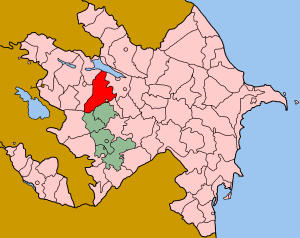
Nizami, Azerbaijan — may refer to: Nizami, Goranboy Nizami, Sabirabad This disambiguation page lists articles about distinct geographical locations with the same name. If an internal link led you here, you may … Wikipedia
Operation Goranboy — Part of the Nagorno Karabakh War Date 12 June 1992 – March 1993 Location Goranboy and Tartar provinces of Azerbaijan Republic … Wikipedia
Meşəli, Goranboy — Meşəli is a village in the municipality of Aşağı Ağcakənd in the Goranboy Rayon of Azerbaijan.[1] References ^ Belediyye Informasiya Sistemi … Wikipedia
Nərimanlı, Goranboy — Nərimanlı is a village and municipality in the Goranboy Rayon of Azerbaijan. It has a population of 1,229.[citation needed] The municipality consists of the villages of Nərimanlı and Cinli Zeynallı.[1] References ^ Belediyye Infor … Wikipedia
List of places named after people — There are a number of places named after famous people. For more on the general etymology of place names see toponomy. For other lists of eponyms (names derived from people) see eponym.Continents*Americas (North America and South America) ndash;… … Wikipedia
Nagorno-Karabakh War — Nagorno Karabakh War … Wikipedia
Aşağı Ağcakənd — Coordinates: 40°25′20″N 46°33′36″E / 40.42222°N 46.56°E / 40.42222; 46.56 … Wikipedia
Mənəşli — Municipality … Wikipedia
Çalaberti — Coordinates: 40°35′09″N 46°43′31″E / 40.58583°N 46.72528°E / 40.58583; 46.72528 … Wikipedia
 Nizami
 Azerbaijan