- Oruk Anam
-
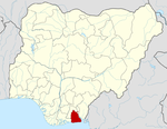
Oruk Anam — LGA — Location in Nigeria Coordinates: 4°49′0″N 7°39′0″E / 4.816667°N 7.65°ECoordinates: 4°49′0″N 7°39′0″E / 4.816667°N 7.65°E Country  Nigeria
State Akwa Ibom State Capital Time zone WAT (UTC+1) Oruk Anam is a Local Government Area located in the South Western part of Akwa Ibom State, Nigeria. It is one of the eight Annang speaking local government areas. It was created from the former Abak Division.
It shares the same boundary with Ikot-Abasi/Mkpat-Enin (Ibibio speakers) by the south/east and Ukanafun (Anaang speakers) by the west. Its population according to the 2006 census is 172,000.[1] Its inhabitant are mostly farmers, craftmen and civil servants. The area is a major gateway to Port Harcourt and Aba as such there is lots of commercial activities along the major road points like Ekparakwa. The area hosts some government interest like the general hospital located in Ikot Okoro, police stations and schools.
References
- ^ "2006 Population Census". The National Bureau of Statistics of Nigeria. http://www.nigerianstat.gov.ng/Connections/Pop2006.pdf. Retrieved 2009-02-26.[dead link]
 Akwa Ibom StateState capital: Uyo
LGAs Abak · Eastern Obolo · Eket · Esit Eket · Essien Udim · Etim Ekpo · Etinan · Ibeno · Ibesikpo Asutan · Ibiono-Ibom · Ika · Ikono · Ikot-Abasi · Ikot Ekpene · Ini · Itu · Mbo · Mkpat-Enin · Nsit-Atai · Nsit-Ibom · Nsit-Ubium · Obot-Akara · Okobo · Onna · Oron · Oruk-Anam · Udung-Uko · Ukanafun · Uruan · Urue-Offong/Oruko · Uyo
 Categories:
- Local Government Areas in Akwa Ibom State
- Populated places in Akwa Ibom State
- Nigeria geography stubs
Wikimedia Foundation. 2010.

