Oulton, West Yorkshire

Oulton, West Yorkshire
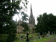
St. John the Evangelist, Oulton

Oulton is a village in the City of Leeds metropolitan borough, West Yorkshire, England, between Leeds and Wakefield. It is at the junction of the A639 and A642 roads. Though now adjoining the village of Woodlesford, it was once quite separate. It was once part of the urban district of Rothwell.

Oulton Hall was built in 1850 and is now a hotel and conference centre.

Oulton's most famous son is Richard Bentley who became Master of Trinity College, Cambridge.

Much of Oulton consists of old, expensive houses. Most especially on Leeds Road (locally known as 'Millionaire's Row') and Farrer Lane. In stark contrast however are the council houses of Holmsley Field Lane, Green Lea, North Lane, Holmsley Walk, Holmsley Field Court, Langdale Road, Northgate, Southgate, Eastgate and Westgate.

Location grid


External links

Coordinates: 53°44′56″N 1°27′04″W / 53.749°N 1.451°W / 53.749; -1.451


Wikimedia Foundation. 2010.

Игры ⚽ Нужно решить контрольную?

Look at other dictionaries:

  • West Yorkshire — Geografie Status: Zeremonielle Grafschaft Region: Yorkshire and the Humber Fläche: 2.209 km² Demografie …   Deutsch Wikipedia

  • West Yorkshire — Infobox England county name = West Yorkshire motto = status = Metropolitan county Ceremonial county origin = 1974(Local Government Act 1972) region = Yorkshire and the Humber arearank = Ranked 29th area km2 = 2029 adminarearank = adminarea km2 =… …   Wikipedia

  • Rothwell, West Yorkshire — infobox UK place country = England official name= Rothwell latitude= 53.75 longitude= 1.48 map type= West Yorkshire population = metropolitan borough= City of Leeds metropolitan county= West Yorkshire region= Yorkshire and the Humber constituency …   Wikipedia

  • Oulton — may refer to: Oulton, Cumbria Oulton, Norfolk Oulton, Staffordshire Oulton, Suffolk Oulton Broad, Suffolk Oulton, West Yorkshire See also Oulton Estate, former house and grounds in Cheshire containing Oulton Park, Motor racing circuit RAF Oulton …   Wikipedia

  • Oulton Hall — Coordinates: 53°44′42″N 1°27′32″W / 53.745°N 1.459°W / 53.745; 1.459 …   Wikipedia

  • Yorkshire del Oeste — El texto que sigue es una traducción defectuosa o incompleta. Si quieres colaborar con Wikipedia, busca el artículo original y mejora o finaliza esta traducción. Puedes dar aviso al autor principal del artículo pegando el siguiente código en su… …   Wikipedia Español

  • National Conference League — competition logo Sport Rugby league football Instituted 1986 Chair …   Wikipedia

  • List of abbeys and priories in England — Contents 1 Overview 1.1 Article layout 2 Abbreviations and key …   Wikipedia

  • List of lakes in England — This is a list of lakes and reservoirs in England. Largest lakes and reservoirs LakeArea (sq mi)1Windermere5.692Kielder Reservoir3.863Ullswater3.444Bassenthwaite Lake2.065Derwent Water2.06 Lakes larger than 5 hectares This list is restricted to… …   Wikipedia

  • Woodlesford — is a village in the metropolitan county of West Yorkshire, England, four miles south east of Leeds City Centre. It is in the City of Leeds metropolitan borough. Woodlesford is now a residential part of the commuter belt that services the city of… …   Wikipedia

Share the article and excerpts

Direct link
Do a right-click on the link above
and select “Copy Link”