- Agia Paraskevi, Lesbos
Infobox Greek Dimos
name = Agia Paraskevi
name_local = Αγία Παρασκευή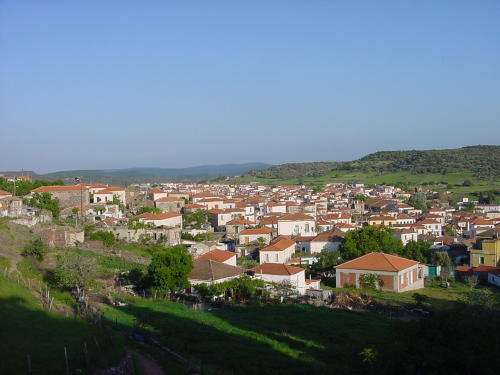
caption_skyline = The Village of Agia Paraskevi, Lesvos as seen from the Church of Ayia Paraskevi
city_
city_
lat_deg = 39
lat_min = 15
lon_deg = 26
lon_min = 24
elevation_min =
elevation_max =
periph =North Aegean
prefec = Lesvos
districts =
mayor = Georgios Kiriazis
party =
since =
population_as_of = 2001
population = 2628
area = 117.697
postal_code = 811 xx
area_code = 225x0-x
licence = MH, MY
website = [http://www.agiaparaskevi.net/ www.agiaparaskevi.net]Agia Paraskevi or Ayia Paraskevi ( _el. Αγία Παρασκευή) is a village and municipality in the Greek island of Lesbos. It is located in the central part of the island, on the northeast shore of the Bay of
Kalloni .The village (pop. 2,268 at the 2001 census) is named after the "Church of Agia Paraskevi", which is found in a cave in one of the highest points of the town. The town cemetery is also located here. Presumably built over an old pagan temple, there is a well in the cave, and drinking the water from this well has been said to have conferred the Virgin Mary's protection. Agia Paraskevi is an old village that is becoming a powerful cultural and economic center for the island. The village is known for its old mansions, unique architecture and for its festivals.
Festivals
The curious
Festival of the Bull of Ayios (Saint) Haralambos has been celebrated in the village since 1774. Every year in June, a bull is sacrificed for good fortune and is a major event for the entire island. The festival is linked to an old story: "During the period of Turkish occupation, a Turk stole a bull. Each time he tried to kill it, a bright light shone in his eyes, until eventually, he gave the bull back."The festival lasts five days and is comprised of several discrete parts. The festivities typically open with the parading of the bull throughout the streets and neighborhoods of the village, closely trailed by a large marching band that plays traditional music that defines the event. Villagers often follow the procession and households will offer silver trays with ouzo shots to riders that follow the musicians through the town. The riders are often dressed in their Sunday best, and the horses are decked out in the finest saddles, reigns, ornaments, and dirlik (Turkish for "blanket that rests beneath the saddle") available. By nightfall, the citizens of the village congregate in the town square and celebrate by feasting at one of the local restaurants, always outdoors, in communal tables amongst thousands of revelers. Live bands dot the main street, blaring traditional Greek songs and hosting all-night dancing. Throughout these festivities, a few of the riders still standing parade their horses through the streets, often with the horses intoxicated and performing stunts to impress the onlookers. Although very exciting, the horses can be ill-tempered when they are spurred on by the riders' ear-nipping or singeing to make them rear up. It is not uncommon to see the riders ejected from the saddle and the horse go buckwild within the confines of the crowded town square. Despite the potential risk, no patron of the festival has ever been maimed or killed, something the villagers attribute openly to the will of Saint Haralambos, the patron saint of the festival.
For the next three days and nights, the festival shifts to quarter-horse races with prize money and bragging rights as the spoils of victory and all-night partying again in the town square. The final night of the festival ends with a trek by car or horse (or even donkey) to the small outlying church of St. Haralambos that rests nearly 30 minutes outside of the village in a remote location. There, the revelers continue the festivities with music blaring through boomboxes, food both brought from home and cooked on the spot, and the blessing of the horses and riders atop the hill in the church of St. Haralambos. By morning, the festival draws to a close, providing fodder for discussion all year until the following year.
The second major festival, albeit much smaller than that of St. Haralambos, is the festival of the Virgin Mary celebrated every 15th of August. Like all locales in Greece, this festival is of exceptional importance and marks a national holiday and opportunity to celebrate religious unity with other Greek brethren. Again, the occasion is marked by festivities in the town square and capped by a visit to the nearest outlying church of the Virgin Mary, some 30 minutes outside the village on a remote mountain by horseback. In the modern era, the horse has been replaced by the pickup truck or car, although a select few choose to keep the romance of the old tradition alive by making the trek on horseback by moonlight up the cobbled passages of the mountain. At the target site, the revelers play loud music and party the night away. In the background, a group of villagers appointed by the town sacrifice a bull and cleave the meat into traditional cauldrons - onions and grains are added to create a semisolid consistency that is cooked all night, known as "kisketch." The kisketch is distributed in plastic containers to all villagers by dawn and enjoyed over the next few days. The recipe remains a closely guarded secret, although occasionally containers of kisketch have been spotted in international ethnic supermarkets, commanding prices in excess of 18 Euros per 100 grams.
Village layout
The village contains many traditional houses that shows the Venetian and Roman occupation of the island and is a rare, non-commercialized, non-tourist village — locals sit at
tavernas that line the main street and socialize. The people are quite friendly and get around on foot, moped, horse, mule, or donkey; however, the automobile has largely supplanted animals as the main mode of transportation of both people and farm produce.Agia Paraskevi contains discrete neighborhoods that have retained sociological personalities that persist throughout the decades. As one enters the village, the first neighborhood is known as "Downtown" ("Sha'Kato"), bracketed by a hilltop borough to the left ("Goumaso," home of the Alexi family which contains 13 children) and the main thoroughfare to the right which leads to the "Agora" (marketplace). At this juncture, two famous landmarks exist: the house of "Limniou," once used by the invading Nazis in the World War II occupation as a command center, now used as the municipal headquarters, and the Oasis ("Oash") Cafe and Bar, a popular family-oriented hangout frequented by visitors in the summer months.
Goumaso is famous for producing street-smart children with a predilection for a benevolent gang-like mentality. As one continues north, the neighborhood of "Silathi" is encountered, noted for its preserved 19th century architecture. Further North, the neighborhood of "Pyrghos" ("Castle") is encountered, famous for being the gateway to the village cemetery and St. Ilias church and also housing the village's most enduring supermarket, known as "Ta Gotzilia."
In the center of the village, the main street can be found, containing dozens of bars, cafes, banks, pharmacies, bakeries, florists, convenience stores, and the village middle school, an architectural landmark and beacon of design throughout Eastern Greece. The Eastern edge of the village contains the largest borough of all, known as "Cafkara." This area is famous for housing the stretch of land horses race upon during the St. Haralambos festival of the bull, as well as a military base staffed by over 150 troops.
Near the village at
Klopedi , are the remains of the ancientAeolia n temple ofNapaios Apollo , whileMessa , also nearby, boasts the ruins of a bigIonia n temple (late 4th–early 3rd century BC), possibly dedicated to three Greek deities:Zeus ,Hera and Dionysos. A monument from a later date, the Early Christianbasilica ofSt. George , restored by the notedmediaevalist ,Professor A. Orlandos , may be seen atHalinados , not far away.The school building of Agia Paraskevi is of neoclassical
architecture of the early 20th century (1922-1930s) has a rectangular "U" ground-plan shape and shows a perfect symmetry at its openings. The formation of the school-yard area is also very significant. The construction of the school building, one of the most attractive on the island, was financed by revenues from the town’s oil-press, which today has been transformed into a multi-cultural center.The Oil-Press of Agia Paraskevi is a complex of stone-built buildings that serves as a characteristic sample of exceptional industrial architecture of the early 20th century (1910) on the island. Initially, it had been operating as an industrial complex (oil-press and
corn-mill ) and later on, until 1967, it ran as a community business. In 1984, with the support of thePrefecture of Lesbos, it was restored and transformed into a cultural center. The central building was turned into a multi-cultural hall with a 400-seat capacity, the oil storehouses were converted to afolk art museum while the 11 olives’ storehouses were transformed into modern guest-houses.The only other significant town in the Municipality of Agía Paraskeví is Nápi (pop. 282), about 3 km to the northeast. In the latest census in 2001 the municipality had 2,628 residents. Its land area is 117.697 km².
References
External links
* [http://www.agiaparaskevi.net/ Official website] en el icon
Wikimedia Foundation. 2010.