- Nelson Reservoir
-
Nelson Reservoir 
Location Apache County, Arizona Coordinates 34°3′21.86″N 109°11′25.63″W / 34.0560722°N 109.1904528°WCoordinates: 34°3′21.86″N 109°11′25.63″W / 34.0560722°N 109.1904528°W Lake type Reservoir Basin countries United States Surface area 60 acres (24 ha) Average depth 15 ft (4.6 m) Surface elevation 7,410 ft (2,260 m) Anyone who has driven from Springerville to Alpine has seen Nelson Reservoir. A long and narrow lake, it follows the Nutrioso Creek Valley for nearly a mile. Fish that remain in Nelson Reservoir after summer stockings can grow to good size, making it a popular fishing site with local anglers.
Contents
Locations
Nelson Reservoir is situated at 7,412 feet (2,259 m) on the Apache-Sitgreaves National Forests, as such the facilities located here are managed by that authority.
Description
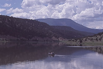
 A stunning view of Nelson Reservoir
Nelson Reservoir is located on Nutrioso Creek. It has 90 acres (36 ha) with a maximum depth of 24 feet (7.3 m) and an average depth of 8 feet (2.4 m). When the lake stops spilling in the spring, it is stocked with up to 20,000 catchable-sized rainbow trout until Labor Day. Stocking may end sooner if water quality conditions become unfavorable. Nelson Reservoir is subject to algae blooms and excessive weed growth as summer progresses. The lake contains native bluehead suckers and illegally introduced black crappie and green sunfish. The lake once contained brown, cutthroat and brook trout, but none remain today.
Fish species
External links
References
- Arizona Fishin' Holes, Phoenix, AZ: Arizona Game and Fish Department, 2007
Categories:- Reservoirs in Arizona
- Lakes of Apache County, Arizona
- Buildings and structures in Apache County, Arizona

Wikimedia Foundation. 2010.