- Cerfontaine, Belgium
-
Cerfontaine 
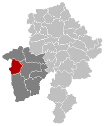
Coat of armsLocation in Belgium Coordinates: 50°10′N 04°25′E / 50.167°N 4.417°E Country Belgium Region Wallonia Community French Community Province Namur Arrondissement Philippeville Government - Mayor Christophe Bombled (MR-IC) - Governing party/ies MR-IC Area - Total 83.45 km2 (32.2 sq mi) Population (1 January 2010)[1] - Total 4,764 - Density 57.1/km2 (147.9/sq mi) Postal codes 5630 Area codes 071 Website www.cerfontaine.be Cerfontaine (French pronunciation: [sɛʁfɔ̃tɛn]) is a Walloon municipality located in Belgium in the province of Namur. On January 1, 2006 Cerfontaine had a total population of 4,546. The total area is 83.45 km² which gives a population density of 54 inhabitants per km².
References
- ^ Population per municipality on 1 January 2010 (XLS; 221 KB)
Municipalities in the Province of Namur Dinant 
Namur Andenne · Assesse · Éghezée · Fernelmont · Floreffe · Fosses-la-Ville · Gembloux · Gesves · Jemeppe-sur-Sambre · La Bruyère · Mettet · Namur · Ohey · Profondeville · Sambreville · SombreffePhilippeville Categories:- Municipalities of Namur
- Belgium geography stubs
Wikimedia Foundation. 2010.


