- Nishi-Kuwana Station
-
Nishi-Kuwana Station西桑名駅
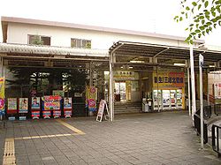
Nishi-Kuwana Station entrance Location Prefecture Mie
(See other stations in Mie)City Kuwana History Year opened 1914 Former name Ōyamada Station Present name since 1931 Rail services Operator(s) Sangi Line(s) Hokusei Line  Large bus terminal(s) attached to the station
Nishi-Kuwana Station (西桑名駅 Nishi-Kuwana-eki) is a train station in Kuwana, Mie Prefecture, Japan. It is the origin of the Hokusei Line.
Contents
Lines
Layout
The station has a single platform.
Adjacent stations
« Service » Sangi Hokusei Line Terminus Local Umamichi Usage
The station is used primarily by morning and evening commuters to school and work. Many passengers proceed on to Nagoya and Yokkaichi via Kintetsu and JR at Kuwana Station.
Surrounding area
- Kuwana Station (JR, Kintetsu, and Yōrō Railway)
- Nagashima Spa Land (via bus)
- Kuwana City Hall
- Kyūka Park, site of the old Kuwana Castle
- Part of Kuwana-juku, a station of the Tōkaidō
- Apita shopping center
History
- April 5, 1914: Station opens as part of Hokusei Railway under the name of Ōyamada Station (大山田駅 Ōyamada-eki).
- July 8, 1931: Station officially renamed Nishi-Kuwana Station.
- June 27, 1934: Hokusei Railway officially renamed Hokusei Electric Railway.
- February 11, 1944: Station falls under the ownership of Sanco following merger.
- November 1, 1961: Kuwana-Kyōbashi ~ Nishi-Kuwana section of Hokusei Line closes. Nishi-Kuwana becomes origin of Hokusei Line.
- February 1, 1964: Station falls under the ownership of Mie Electric Railway after railway division of Sanco splits off and forms separate company.
- April 1, 1965: Station falls under the ownership of Kintetsu following merger.
- May 1, 1977: Station moved slightly to the south.
- April 1, 2003: Kintetsu transfers control of Hokusei Line to Sangi Railway. Station falls under the ownership of Sangi.
- August 31, 2003: Heating and air conditioning installed in passenger waiting room.
- December 1, 2003: Automatic ticket gates installed. Fair adjustment machine installed.
- March 26, 2005: Hokusei Line control station moved from Nishi-Kuwana to Tōin.
References
- (Japanese) Wikipedia: Nishi-Kuwana Station
External links
35°03′56″N 136°41′02″E / 35.065437°N 136.683806°ECoordinates: 35°03′56″N 136°41′02″E / 35.065437°N 136.683806°E

This Mie Prefecture railroad station-related article is a stub. You can help Wikipedia by expanding it.
