- Eastern Oregon Regional Airport
Infobox Airport
name = Eastern Oregon Regional Airport
nativename =
nativename-a =
nativename-r =
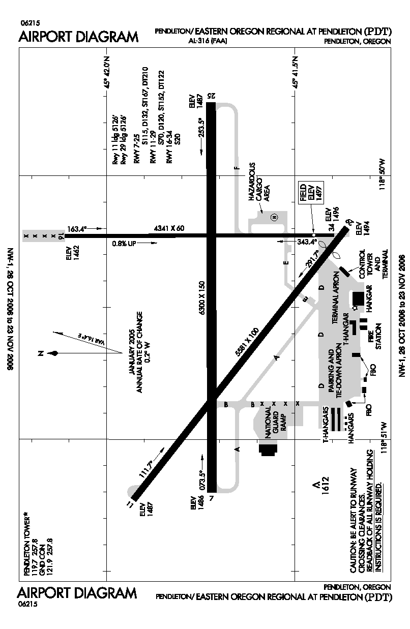
image-width =
caption =
IATA = PDT
ICAO = KPDT
type = Public
owner =
operator = City of Pendleton
city-served =
location = Pendleton, Oregon
elevation-f = 1,497
elevation-m = 456.3
coordinates = Coord|45|41|42|N|118|50|29|W|type:airport_region:US|display=inline,title
website =
metric-elev =
metric-rwy =
r1-number = 7/25
r1-length-f = 6,300
r1-length-m = 1,920
r1-surface =Asphalt
r2-number = 11/29
r2-length-f = 5,581
r2-length-m = 1,701
r2-surface = Asphalt
r3-number = 16/34
r3-length-f = 4,341
r3-length-m = 1,323
r3-surface = Asphalt
stat-year =
stat1-header =
stat1-data =
stat2-header =
stat2-data =
footnotes =Eastern Oregon Regional Airport Airport codes|PDT|KPDT, also known as Eastern Oregon Regional Airport at Pendleton, is a public
airport located three miles (5 km) northwest of thecentral business district (CBD) of Pendleton, a city in Umatilla County,Oregon , USA. The airport covers convert|2273|acre|ha|0|lk=on and has threerunway s. It is used primarily forgeneral aviation , but is also served by one commercial airline. Service is subsidized by theEssential Air Service program. Recently, Horizon has announced that it will be launching service from Seattle and Walla Walla to Pendleton with its 74-seater, Q400. However, Horizon did also mention that service to Portland and Pasco will be reduced in terms of seat capacity and frequencies. This is due to Horizon's phasing out of its Q200 fleet.Airline and destinations
*
Alaska Airlines
**Horizon Air (Pasco [ends October 27] , Portland (OR) [ends October 27] , Seattle/Tacoma [begins October 28] , Walla Walla [begins October 28] )Cargo carriers
*
FedEx Express
*UPS Airlines References
* [http://www.pendleton.or.us/airport.htm Eastern Oregon Regional Airport] (City of Pendleton web site)
*FAA-airport|ID=PDT|use=PU|own=PU|site=19562.*AExternal links
*FAA-diagram|00316
*Essential Air Service documents ( [http://dms.dot.gov/search/searchResultsSimple.cfm?searchType=docket&sortBy=desc&numberValue=19934 Docket Number 19934] ) from the U.S. Department of Transportation:
** [http://dms.dot.gov/search/document.cfm?documentid=454025&docketid=19934 Order 2007-2-19: Horizon Air, operating as Alaska, Continental and Northwest Airlines code-share partners, to provide subsidized EAS through April 30, 2009]
** [http://dms.dot.gov/search/document.cfm?documentid=430333&docketid=19934 Order 2006-11-19: Request for proposals to provide essential air service for two years, beginning April 3, 2007]
** [http://dms.dot.gov/search/document.cfm?documentid=322505&docketid=19934 Order 2005-3-35: Horizon Air to provide subsidized essential air servicefor two years, ending April 2, 2007]
Wikimedia Foundation. 2010.