Mahinog, Camiguin

Mahinog, Camiguin
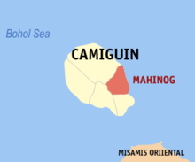
Map of Camiguin showing the location of Mahinog

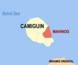
Mahinog is a 5th class municipality in the province of Camiguin, Philippines. According to the 2000 census, it has a population of 12,592 people in 2,488 households.

It is bounded in the north by the town of Mambajao, on the south by the municipality of Guinsiliban, on the east by Mindanao Sea and on the west by Mt. Timpoong.

History

On 1942, the invasion of the Japanese Occupation forces landed the town of Mahinog, Camiguin.

On 1945, the liberation of the Filipino troops of the 6th and 10th Infantry Division of the Philippine Commonwealth Army was entering the town of Mahinog, Camiguin against the Japanese Imperial Army forces during the Battle of Camiguin at the end in the Second World War.

Barangays

Mahinog is politically subdivided into 14 barangays.

  • Benoni
  • Binaliwan
  • Catohugan
  • Hubangon
  • Owakan
  • Poblacion
  • Puntod
  • San Isidro
  • San Jose
  • San Miguel
  • San Roque
  • Tacangon
  • Tubod
  • Tupsan Pequeño

External links

Coordinates: 9°09′N 124°47′E / 9.15°N 124.783°E / 9.15; 124.783


Wikimedia Foundation. 2010.

Игры ⚽ Нужно решить контрольную?

Look at other dictionaries:

  • Mahinog — Municipality of Mahinog Lage von Mahinog in der Provinz Camiguin Basisdaten Bezirk …   Deutsch Wikipedia

  • Camiguin — This is the article on the island province of Camiguin in the Philippines. There is a different Camiguin Island, part of the Babuyan Islands, also in the Philippines. Infobox Philippine province name = Camiguin sealfile = Ph seal camiguin.png… …   Wikipedia

  • Camiguin — Lage der Provinz Camiguin Karte mit Camiguin im südlichen Teil der Boholsee Camiguin ist e …   Deutsch Wikipedia

  • Camiguin — 9° 10′ 00″ N 124° 43′ 01″ E / 9.16667, 124.717 …   Wikipédia en Français

  • Camiguin — ▪ island, Philippines       mountainous island in the Bohol (Mindanao) Sea, 6 miles (10 km) off the northern coast of Mindanao, Philippines. Located near Macajalar and Gingoog bays, the island is often considered the most beautiful of the… …   Universalium

  • Mambajao, Camiguin — Map of Camiguin showing the location of Mambajao …   Wikipedia

  • Catarman (Camiguin) — Municipality of Catarman Lage von Catarman in der Provinz Camiguin Basisdaten Bezirk …   Deutsch Wikipedia

  • Sagay (Camiguin) — Municipality of Sagay Lage von Sagay in der Provinz Camiguin Basisdaten Bezirk: Northe …   Deutsch Wikipedia

  • PH-CAM — Lage der Provinz Camiguin Camiguin ist eine philippinische Provinz und Insel. Sie liegt nur 10 km nördlich der großen Insel Mindanao, der südlichsten Insel der Philippinen. Von der Nordküste Camiguins aus kann man noch gut die Silhouette der 54… …   Deutsch Wikipedia

  • Камигин — тагальск. Kamiguin Страна Филиппины Статус провинция Входит в Регион Северный Минданао Включае …   Википедия

Share the article and excerpts

Direct link
Do a right-click on the link above
and select “Copy Link”