- Mwenezi River
-
Mwenezi River 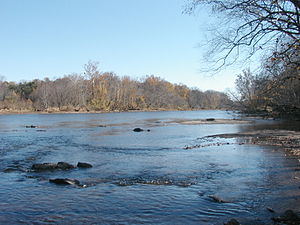
Mwenezi River in Zimbabwe lowveldOrigin Insiza District, South Central Zimbabwe Mouth Limpopo River Basin countries Zimbabwe, Mozambique Avg. discharge 14.34 mm/a (unit flow)[1] Basin area 14,759 km2 Mwenezi River is a major tributary of the Limpopo River. The Mwenezi River starts up in south central Zimbabwe and flows south-east along what is known as the Mwenezi River Vally that bisects the district into two sectors.[2][3]. The river is found in both Zimbabwe and Mozambique. In Zimbabwe it has been known as the Nuanetsi or Nuanetzi River in the past, a name it retains in Mozambique[4].
The river flows through Gonarezhou National Park on its way to joining the mighty Limpopo River. The Mwenezi river is a major tributary and flows north-south. They do not meet in Zimbabwe, but converge to a distance of 20 km downstream into Chicualacuala District, Mozambique. In between is the Sengwe Communal Land in Chiredzi District of Masvingo Province, mostly a flat and undulating area around 300 m in altitude.
Contents
Hydrology

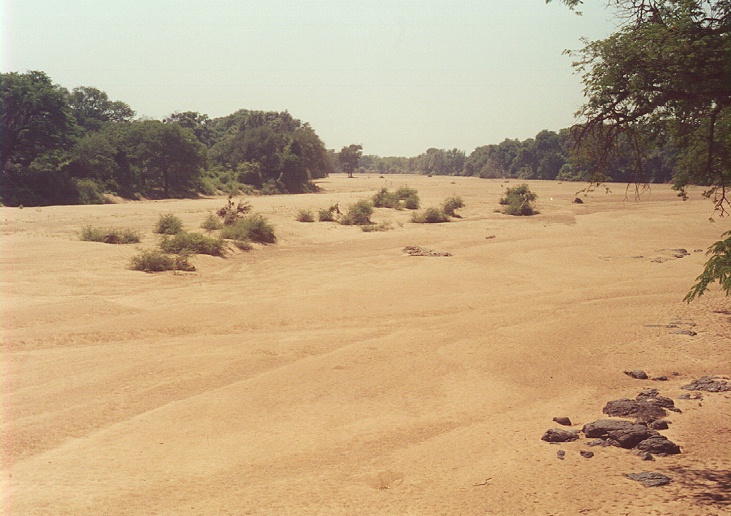
The Mwenezi River is a river with an intermittent flow generally restricted to the months when rain takes place (November to April), with most flow recorded between December and February, except where it has been modified by dam operations [5]. The river contributes 6.7 % of the mean annual runoff of the Limpopo Basin, making it the third largest tributary to the Limpopo basin [6].
Its major tributaries are the Dinhe, Manyoshi, Mtedzi, Mhondi, Makugwe, Sosonye, Sovoleli, Malole, Mwele and Mushawe rivers.
Cities, Towns and Settlements along the River
The settlements and cities below are ordered from the beginning of the river to its end:
- Chegato mission
- Mwenezi village
- Mabalauta Camp, Gonarezhou National Park
- Malipati village
Bridges and Crossings
 Ford on the Mwenezi River at Mazetese, upstream of Manyuchi Dam.
There are four main bridges over the Mzingwane River:
- Bridge on main Masvingo - Beitbridge road, near Rutenga. There is also a rail bridge.
- Bridge on Chegato - Mataga road
- Bridge on Dinhe - Neshuro road
- Bridge near Malipati on road from Chikombedzi
There are also a number of fords.
Development
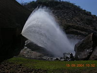 Water released from Manyuchi Dam, Mwenezi.
In addition to a number of small weirs, there is one major dam on the Mzingwane River: Manyuchi Dam in Mwenezi (District), which supplies water to Rutenga and for the irrigation of sugar cane. Water released from the Manyuchi Dam is taken up for these users at Rinette Weir.
Two additional dam sites have been identified between Manyuchi Dam and Mwenezi village, but development is not currently scheduled [7].
Wildlife
 A hammerkop on the banks of the river. The locals call it 'Kondo' and there are songs about it., 2006
The river supports a diverse range of wildlife, including herons, hippos and Nile crocodiles. A number of people lose their lives to these crocodiles, as well as countless domestic animals like goats, calves and donkeys.[8]
See also
External links
- Flora of Zimbabwe [5]
References
- ^ Görgens, A.H.M. and Boroto, R.A. 1997. Limpopo River: flow balance anomalies, surprises and implications for integrated water resources management. In: Proceedings of the 8th South African National Hydrology Symposium, Pretoria, South Africa.
- ^ Mwenezi River & tributaries in Mwenezi (District)
- ^ Flora of Zimbabwe [1](accessed 20 February 2008)
- ^ Ministério da Administração Estatal 2005. Perfil do Distrito de Chicualacuala, Província de Gaza, page 2 [2]
- ^ Love, D., Uhlenbrook, S., Nyabeze, W., Owen, R.J.S., Twomlow, S., Savenije, H. , Woltering, L. and van der Zaag, P. 2005. Modelling of hydrological change for IWRM planning: case study of the Mzingwane River, Limpopo Basin, Zimbabwe. In: Abstract Volume, 6th WaterNet/WARFSA/GWP-SA Symposium, Ezulwini, Swaziland, November 2005, p31.[3]
- ^ Görgens, A.H.M. and Boroto, R.A. 1997. Limpopo River: flow balance anomalies, surprises and implications for integrated water resources management. In: Proceedings of the 8th South African National Hydrology Symposium, Pretoria, South Africa.
- ^ Chibi, T., Kandori, C. and Makone, B.F. 2005. Mzingwane Catchment Outline Plan. Zimbabwe National Water Authority, Bulawayo.
- ^ Crocodile Attack [4] (accessed 19 February 2008)
Business Centers Place & Names Rivers of Zimbabwe Rivers Bubye · Chiredzi · Gwayi · Honde · Inkankezi · Insiza · Inyankuni · Kwekwe · Limpopo · Luenha · Manyame · Mazowe · Mtshabezi · Mtshelele · Mucheke · Munyati · Mupfure · Mushawe · Mutirikwe · Mwenezi · Mwewe · Mtetengwe · Mzingwane · Ncema · Ngezi (Masvingo) · Ngezi (Midlands) · Panhane · Pungwe · Runde · Save · Sebakwe · Sengwa · Shangani · Shashe · Siwaze · Tokwane · Tokwe · Thuli · Umchabezi · Zambezi
Categories:- Rivers of Zimbabwe
- Mwenezi River
- Masvingo Province
- Mwenezi (District)
- Rivers of Mozambique
- International rivers of Africa


Wikimedia Foundation. 2010.