- Nelsonville, New York
-
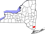
Nelsonville, New York — Village — Location within the state of New York
 Nelsonville, New York
Coordinates: 41°25′28″N 73°56′39″W / 41.42444°N 73.94417°WCoordinates: 41°25′28″N 73°56′39″W / 41.42444°N 73.94417°W Country United States State New York County Putnam Area – Total 1.0 sq mi (2.7 km2) – Land 1.0 sq mi (2.7 km2) – Water 0.0 sq mi (0.0 km2) Elevation 187 ft (57 m) Population (2000) – Total 565 – Density 541.6/sq mi (209.1/km2) Time zone Eastern (EST) (UTC-5) – Summer (DST) EDT (UTC-4) ZIP code 10516 Area code(s) 845 FIPS code 36-49781 GNIS feature ID 0970401 Nelsonville is a Hudson Highlands village located in the Town of Philipstown in Putnam County, New York. The population was 565 at the time of the 2000 census.
The Village of Nelsonville is directly east of the Village of Cold Spring. The border on Main Street is roughly demarcated by the western property line of the Baptist Church at the height of land, and by the property line along the rear of the church lot, extending south toward the Cold Spring Cemetery.
Along with its neighbor, Cold Spring, the village is known for being a small, picturesque enclave with a historic housing stock. It is located within the larger New York City metropolitan area, and it offers a genuine village feel within a reasonable commuting distance to the city. It is a popular weekend and fall foliage destination for New York City residents, and the origin of several well-known hiking trails that travese the Hudson Highlands. The village is served by the Cold Spring Metro North commuter railroad stop on the Hudson Line.
Contents
Geography
Nelsonville is located at 41°25′28″N 73°56′39″W / 41.42444°N 73.94417°W (41.424550, -73.944170)[1].
According to the United States Census Bureau, the village has a total area of 1.0 square mile (2.6 km2), all of it land.
Demographics
As of the census[2] of 2000, there were 565 people, 222 households, and 154 families residing in the village. The population density was 541.6 people per square mile (209.8/km²). There were 246 housing units at an average density of 235.8 per square mile (91.3/km²). The racial makeup of the village was 96.28% White, 1.77% African American, 0.35% Asian, 0.71% from other races, and 0.88% from two or more races. Hispanic or Latino of any race were 3.72% of the population.
There were 222 households out of which 29.7% had children under the age of 18 living with them, 53.6% were married couples living together, 10.4% had a female householder with no husband present, and 30.6% were non-families. 22.5% of all households were made up of individuals and 6.8% had someone living alone who was 65 years of age or older. The average household size was 2.50 and the average family size was 2.99.
In the village the population was spread out with 24.2% under the age of 18, 4.8% from 18 to 24, 31.7% from 25 to 44, 27.4% from 45 to 64, and 11.9% who were 65 years of age or older. The median age was 40 years. For every 100 females there were 102.5 males. For every 100 females age 18 and over, there were 103.8 males.
The median income for a household in the village was $60,000, and the median income for a family was $67,778. Males had a median income of $42,206 versus $45,625 for females. The per capita income for the village was $24,853. About 3.6% of families and 7.7% of the population were below the poverty line, including 6.1% of those under age 18 and 3.1% of those age 65 or over.
References
- ^ "US Gazetteer files: 2010, 2000, and 1990". United States Census Bureau. 2011-02-12. http://www.census.gov/geo/www/gazetteer/gazette.html. Retrieved 2011-04-23.
- ^ "American FactFinder". United States Census Bureau. http://factfinder.census.gov. Retrieved 2008-01-31.
External links
Municipalities and communities of Putnam County, New York Towns Carmel | Kent | Patterson | Philipstown | Putnam Valley | Southeast
Villages Brewster | Cold Spring | Nelsonville
CDPs Brewster Hill | Carmel | Lake Carmel | Mahopac | Peach Lake‡ | Putnam Lake
Other
hamletFootnotes ‡This populated place also has portions in an adjacent county or counties
Categories:- Villages in New York
- Populated places in Putnam County, New York


Wikimedia Foundation. 2010.