- Lawrence, Massachusetts
Infobox Settlement
official_name = Lawrence, Massachusetts
nickname = Immigrant City
motto =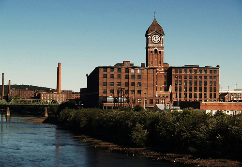
imagesize =
image_caption = Ayer Mill
image_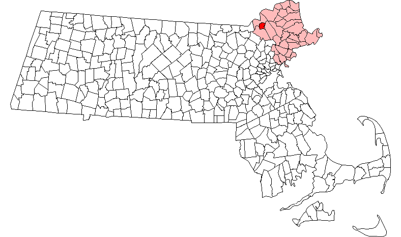
mapsize = 250px
map_caption = Location in Essex County in Massachusetts
mapsize1 =
map_caption1 =
subdivision_type = Country
subdivision_name =United States
subdivision_type1 = State
subdivision_name1 =Massachusetts
subdivision_type2 = County
subdivision_name2 = Essex
established_title = Settled
established_date = 1655
established_title2 = Incorporated
established_date2 = 1847
established_title3 =
established_date3 =
government_type = Mayor-council city
leader_title =Mayor
leader_name = Michael J. Sullivan (R)
leader_title1 = City Council President
leader_name1 =Patrick Blanchette
area_magnitude =
area_total_km2 = 19.2
area_total_sq_mi = 7.4
area_land_km2 = 18.0
area_land_sq_mi = 7.0
area_water_km2 = 1.2
area_water_sq_mi = 0.5
population_as_of = 2007
settlement_type =City
population_total = 70,066
population_density_km2 = 3,892.6
population_density_sq_mi = 10,009.4
elevation_m = 15
elevation_ft = 50
timezone = Eastern
utc_offset = -5
timezone_DST =EDST
utc_offset_DST = -4
latd = 42 |latm = 42 |lats = 25 |latNS = N
longd = 71 |longm = 09 |longs = 49 |longEW = W
website = [http://www.cityoflawrence.com/ www.cityoflawrence.com]
postal_code_type = ZIP code
postal_code = 01840
area_code = 351 / 978
blank_name = FIPS code
blank_info = 25-34550
blank1_name =
blank1_info =
footnotes =Lawrence is a city in
Essex County, Massachusetts ,United States on theMerrimack River . As of the 2000 census, the city had a total population of 72,043. Surrounding communities include Methuen to the north, Andover to the southwest, and North Andover to the southeast. It and Salem are thecounty seat s of Essex County.GR|6 Lawrence is also part of theMerrimack Valley .Manufacturing products of the city include electronic equipment, textiles, footwear, paper products, computers, and foodstuffs. Lawrence was, for a while, the residence of
Robert Frost , where he published his firstpoem .History
Founding and rise as a textile center
Europeans first settled the area in 1640. The site of the city – formerly parts of Andover and Methuen – was purchased in 1845 by a group of Boston industrialists headed by the wealthy merchant and congressman
Abbott Lawrence , the community's namesake. The city was incorporated in 1853.The industrialists, most prominently Lawrence, established textile mills near sources of abundant waterpower. Lawrence's location on the
Merrimack River , just downriver of Lowell and a short train ride from Boston was an ideal location to set up an industrial center. The Merrimack was dammed right above the city, and a canal was dug on both the north and the south banks to provide power to the factories that would soon be built on its banks.The Bread and Roses strike of 1912
Working conditions in the mills were unsafe and in 1860 the
Pemberton Mill factory collapsed, killing 145 workers. [ cite news |url=http://query.nytimes.com/gst/abstract.html?res=9902E6DC1638E533A2575BC1A9629C94679FD7CF |title=THE FALL OF THE PEMBERTON MILL. |publisher="The New York Times |date=April 18, 1886 ] As immigrants flooded into the United States in the late 19th century, the native population of Lawrence was replaced by unskilled workers from Ireland, Italy, Quebec, Germany and a wide assortment of other foreign lands. In 1912 the so-called Bread and Roses strike or theLawrence textile strike , one of greatest labor actions in American history, began when Massachusetts law reduced the work week from 56 hours to 54 hours and subsequently lowered wages for thousands of women and child workers. The strike began on January 11, 1912 when mill workers discovered their pay had been reduced. The average worker at the time earned a mere $7 a week and paid an equal amount for their monthly rent. Unlike the strikes of today fewer than 1000 of the 25,000 strikers were members of a union. The Industrial Workers of the World (I.W.W.) provided most of the leadership for the strike and also provided food and clothing for the strikers. The Massachusetts National Guard, private and city police countered 25,000 strikers for two months. Although there were many skirmishes between the police, militia and the strikers only 2 people died and relatively few were injured on either side. Immigrant groups normally mistrustful of one another banded together in the common cause of higher wages. When police and National Guard assaulted a group of women and children, public outcry forced mill owners to capitulate. The striking workers won wage increases for themselves and thousands of workers across New England. One of the major companies involved in the strike was theAmerican Woolen Company , led ironically by a Portuguese immigrant,William Madison Wood who had risen through the ranks in the textile industry.Post-War history
Lawrence was a great wool-processing center until that industry declined in the 1950s. The decline left Lawrence a struggling city. The population of Lawrence declined from over 80,000 residents in 1950 to approximately 64,000 residents in 1980, the low point of Lawrence's population.
Urban renewal
Like other northeastern cities suffering from the effects of Post World War II industrial decline, Lawrence has often made efforts at revitalization, some of them controversial. For example, half of the enormous water-poweredFact|date=June 2008 Wood Mill, once the largest mills in the world, was knocked down in the 1950s. Nothing has been built on the site other than a quarter-mile -long parking lot. More significantly, under the guise of "
urban renewal ", large tracts of downtown Lawrence were razed in the mid-1970s and replaced with a parking lots and a three-story parking garage connected to a new Intown Mall intended to compete with newly constructed suburban malls. The historic Theater Row along Broadway was also razed, destroying ornate movie palaces of the 1920s and 1930s that entertained mill workers through theGreat Depression and the Second World War. Additionally, the city's main post office, an ornate federalist style building at the corner of Broadway and Essex Street, was razed. Most of the structures were replaced with one-story, steel-frame structures with large parking lots, housing such establishments as fast food restaurants and chain drug stores, fundamentally changing the character of the center of Lawrence. [ [http://www.lawrencemainstreets.org/history.htm Lawrence Main Streets Inc ] ]Lawrence also attempted to increase its employment base by attracting industries unwanted in other communities, such as waste treatment facilities and incinerators. From 1980 until 1998, private corporations operated two trash incinerators in Lawrence. Activist residents successfully blocked the approval of a waste treatment center on the banks of the Merrimack River near the current site of Salvatore's Pizza on Merrimack Street.
Troubles of the 1980s and 1990s
Hispanic immigrants from the
Dominican Republic andPuerto Rico began arriving in Lawrence in significant numbers in the late 1960s, attracted by cheap housing and a history of tolerance toward immigrants. In 1984, tensions between remaining working class whites and increasing numbers of Hispanic youth flared into a riot, centered at the intersection of Haverhill Street and Railroad Street where a number of buildings were destroyed byMolotov cocktail s and over 300 people were arrested. [ [http://main.wgbh.org/ton/programs/2991_01.html 10 O'Clock News | [Race riots in Lawrence ] ]Lawrence saw further setbacks during the recession of the early 1990s as a wave of arson plagued the city. Over 200 buildings were set alight in an eighteen month period in 1991–92, many of them abandoned residences and industrial sites. [ [http://findarticles.com/p/articles/mi_hb5249/is_199208/ai_n20039476 Arson epidemic continues in Massachusetts town. (Lawrence, Massachusetts) | National Underwriter Property & Casualty-Risk & Benefits Management | Find Articles at BNET.com ] ]
Recent trends
Recently, a sharp reduction in violent crime starting in 2004 and massive private investment in former mill buildings along the Merrimack River, including the remaining section of the historic Wood Mill – to be converted into commercial, residential and education uses – have lent encouragement to boosters of the city. One of the final remaining mills in the city is
Malden Mills . Additionally, Lawrence's downtown has seen a resurgence of business activity as Hispanic-owned businesses have opened along Essex Street, the historic shopping street of Lawrence that remained largely shuttered since the 1970s. In June 2007, the City approved the sale of the Intown Mall, largely abandoned since the early 1990s recession, to Northern Essex Community College for the development of a medical sciences center. A large multi-structure fire in January 2008 was national news and destroyed many wooden structures just south of downtown.History of Lawrence immigrant communities
Lawrence has been aptly nicknamed the "Immigrant City."cite book |author=Cole, Donald B. |title=Immigrant City: Lawrence, Massachusetts, 1845-1921 |publisher=University of North Carolina Press |location=|year=1963 |pages= |isbn=0807808768 |oclc= |doi=] Starting with the Irish in the 1840s, it has been home to numerous different immigrant communities, most of whom arrived during the great wave of European immigration to America that ended in the 1920s. Since early 1970s, Lawrence has become home to a sizable Hispanic population, reaching over 68% of the population of Lawrence by 2006.
Immigrant communities, 1845–1920
Lawrence became home to large groups of immigrants from Europe, beginning with the Irish in 1845, Germans after the social upheaval in Germany in 1848, and French Canadians seeking to escape hard northern farm life from the 1850s onward. A second wave began arriving after 1900, as part of the great mass of Italian and Eastern European immigrants, including Jews from Russia, Poland, Lithuania and neighboring regions. Immigration to the United States was severely curtailed in the 1920s with the
Immigration Act of 1924 , when foreign born immigration to Lawrence virtually ceased for over 40 years. In 1890, the foreign-born population of 28,577 was comprised as follows, with the significant remainder of the population being children of foreign born residents: 7,058 Irish; 6,999 French Canadians; 5,131 English; 2,465 German; 1,683 English Canadian. [ [http://www.1911encyclopedia.org/Lawrence,_Massachusetts Wadsworth, H.A. History of Lawrence, Massachusetts (Lawrence, 1880).] ] In 1920, towards the end of the first wave of immigration, most ethnic groups had numerous social clubs in the city. The Portuguese had 2; the English had 2; the Jews had 3; the Armenians, 5; the Lebanese and Syrians, 6; the Irish, 8; the Polish, 9; the French Canadians and Belgian-French, 14; the Lithuanians, 18; the Italians, 32; and the Germans, 47. However, the center of social life, even more than clubs or fraternal organizations, was churches. Lawrence is dotted with churches, many now closed, torn down or converted into other uses. These churches signify, more than any other artifacts, the immigrant communities that once lived within walking distance of each church.cite book |author=Skulski, Ken; Dengler, Eartha; Khalife, Katherine |title=Lawrence, Massachusetts |publisher=Arcadia Pub |location=Dover, N.H |year=1995 |pages= |isbn=0-7524-0229-3 |oclc= |doi=]The Irish
Irish immigrants arrived in Lawrence at its birth, which nearly coincided with the Great Potato Famine of 1842, the event that drove great numbers of Irish out of Ireland. The Great Stone Dam, constructed in from 1845–1848 to power the nascent textile mills, was largely built by Irish laborers. The first Irish immigrants settled in the area south of the Merrimack River near the intersection of Kingston Street and South Broadway. Their shantytown settlement put them close to the dam being constructed, but away from the Essex Corporation row houses built north of the river to attract New England farm girls as millworkers. The religious needs of the Irish were initially met by the Immaculate Conception church, originally erected near the corner of Chestnut and White Street in 1846, the first Roman Catholic church in Lawrence. By 1847, observers counted over ninety shanties in the Irish shantytown. In 1869, [ [http://www.saintpatrickparish.com/html/parish_history.html Parish History ] ] the Irish were able to collect sufficient funds form their own church, St. Patrick’s, on South Broadway.
The Germans
The first sizeable German community arrived following the revolutions of 1848. However, a larger German community was formed after 1871, when industrial workers from Saxony were displaced by economic competition from new industrial areas like the Ruhr. McCaffery, Robert Paul McCaffery. "Islands of Deutschtum: German-Americans in Manchester, New Hampshire and Lawrence, Massachusetts, 1870-1942". New German-American studies, vol 11. Peter Lang, 1996.] The German community was characterized by numerous school clubs, shooting clubs, national and regional clubs, as well as men’s choirs and mutual aid societies, many of which were clustered around the Turn Verein, a major social club on Park Street.
The Italians
Some Italian immigrants celebrated Mass in the basement chapel of the largely Irish St. Laurence O’Toole Church, at the intersection of East Haverhill Street and Newbury Street, until they had collected sufficient funds to erect the Holy Rosary Church in 1909 nearby at the intersection of Union Street and Essex Street. Immigrants from the Sicilian province of Catania maintained a particular devotion to three Catholic martyrs, Saint Alfio, Saint Filadelfo and Saint Cirino, and in 1923 began celebrating a procession on their feast day. [ [http://www.centamore.it/TreSanti/WithTrueFaith_Testo.asp Festa of Saints Alfio, Filadelfo, and Cirino ] ] Although most of the participants live in neighboring towns, the Feast of Three Saints festival continues in Lawrence today.
The French Canadians
French Canadians were the second major immigrant group to settle in Lawrence. In 1872, they erected their first church, St. Ann’s, at the corner of Haverhill and Franklin Streets. Within decades, St. Ann’s established a “missionary church”, Sacred Heart on South Broadway, to serve the burgeoning Québécois community in South Lawrence.
The Syrians
Lawrence residents frequently referred to their Arabic-speaking Middle Eastern community as "Syrian." In fact, most so-called Syrians in Lawrence were from present-day Lebanon, and were largely Maronite Christian. Lebanese immigrants organized St. Anthony’s Marionite Church in 1903 [ [http://www.stanthonylawrence.org/history1.htm St. Anthony’s Marionite Church Website] ] , as well as St. George’s Orthodox Church, the oldest Greek Orthodox-rite Church in the United States.
The Jews
Jewish merchants became increasingly numerous in Lawrence and specialized in dry goods and retail shops. The fanciest men's clothing store in Lawrence, Kap's, established in 1902 and closed in the early 1990s, was founded by Elias Kapelson, born in Lithuania. Jacob Sandler and two brothers also immigrated from Lithuania in approximately 1900 and established Sandlers Department Store, which continued in business until 1978. In the 1880s, the first Jewish arrivals established a community around Common, Valley, Concord and Lowell Streets. In the 1920s, the Jews of Lawrence began congregating further up Tower Hill, where they erected two synagogues on Lowell Street above Milton Street, as well as a Jewish Community Center on nearby Haverhill Street. All three institutions had closed their doors by 1990 as the remaining elderly members of the community died out or moved away.
The Polish
The Polish community of Lawrence was estimated to be only 600–800 persons in 1900. However by 1905, the community had expanded sufficiently to fund the construction of the Holy Trinity Church at the corner of Avon and Trinity Streets. Their numbers grew to 2,100 Poles in 1910. Like many of their immigrant brethren from other nations, most of the Poles were employed in woolen and worsted goods manufacturing. [ [http://www.polishroots.org/paha/polish_farmers_workers.htm Polish Roots website] ]
The English
A sizeable English community, comprised mainly of unskilled laborers that arrived after 1880, sought work in the textile mills where they were given choice jobs by the Yankee overseers on account of their shared linguistic heritage and close cultural links.
Yankee farmers
Not all immigrants to Lawrence were foreign-born or their children. Yankee farmers, unable to compete against the cheaper farmlands of the Midwest that had been linked to the East coast by rail, settled in corners of Lawrence. Congregationalists were the first Protestant denomination to begin worship in South Lawrence, with the erection in 1852 of the first South Congregational Church on South Broadway, near the corner of Andover Street.
New immigrants, 1970 to present
Immigration of foreign born workers to Lawrence largely ceased in 1921 with the passage of strict quotas against immigrants from the countries that had supplied the cheap, unskilled workers. Although many quotas were lifted after the Second World War, foreign immigration to Lawrence only picked up again in the late 1960s with Hispanic immigrants from the Dominican Republic and Puerto Rico as well as other Latin American countries. Immigrants from southeast Asia, particularly Vietnam, have also settled in Lawrence. As an indication of recent immigration trends, St. Patrick’s Church, the largest Catholic church in Lawrence and once an Irish bastion, has celebrated Spanish masses on Sundays since 1999. A mass in Vietnamese is also offered every other week. [ [http://www.mfh.org/newsandevents/newsletter/MassHumanities/Spring2005/parrish.html "Scenes from a Parish":Mass Humanities, Spring 1995] ] Since the 1990s, increasing numbers of former Catholic churches, closed since the 1980s when their Irish or Italian congregations died out, have been bought by Hispanic evangelical churches. [ [http://www.eagletribune.com/homepage/local_story_360094509?keyword=leadpicturestory+page=0 Betances, Yadira. "Protestant congregations eyeing vacant Catholic church properties Yadira Betances. Eagle-Tribune, December 26, 2006.] ]
The 2000 Census revealed the following population breakdown, illustrating the shift toward newer immigrant groups:
· Dominican Republic - 22%· Puerto Rican - 22%· Other Hispanic or Latino - 12%· Irish - 7%· Italian - 7%· French (except Basque) - 5%· Black or African American - 5%· French Canadian - 5%· English - 3%· Arab - 2%· German - 2%· Lebanese - 2%· Central American: - 1%· Polish - 1%· Portuguese - 1%· Guatemalan - 1%· Vietnamese - 1%· South American - 1%· Spanish - 1%· Cambodian - 1%· Scottish - 1%· Cuban - 1%· Scotch-Irish - 1%· Ecuadorian - 1%. [ [http://www.epodunk.com/cgi-bin/genealogyInfo.php?locIndex=2999 Current censurs data on Epodunk.com accessed 04/09/2008] ]
Geography
Lawrence is located at coor dms|42|42|13|N|71|9|47|W|city (42.703741, -71.162979).GR|1According to the
United States Census Bureau , the city has a total area of 7.4square mile s (19.2km² ), of which, 7.0 square miles (18.0 km²) of it is land and 0.4 square miles (1.2 km²) of it (6.07%) is water.Aside from the
Merrimack River , other water features include theSpicket River , which flows into the Merrimack from Methuen, and theShawsheen River , which forms the southeastern border of the city. Additionally, Lawrence has two power canals that were formerly used to providehydropower to the mills - one on the north bank of the river, the other on the south. Channeling water into these canals is theGreat Stone Dam , which lies across the entire Merrimack and was, at the time of its construction in the 1840s, the largest dam in the world.The highest point in Lawrence is the top of Tower Hill in the northwest corner of the city, rising approximately 240 feet above sea level. Other prominent hills include Prospect Hill, in the northeast corner of the city, and Mount Vernon, along the southern edge of the city. Most industrial activity was concentrated in the flatlands along the rivers.
Den Rock Park, a wooded conservation district on the southern edge of Lawrence that spans the Lawrence-Andover town line, provides recreation for nature lovers and rock-climbers alike. [ [http://www.groundworklawrence.org/events/Den_Rock_Park_Guide.pdf Den Rock Park Trail Guide] ]
Demographics
USCensusPop
1850= 8282
1860= 17639
1870= 28921
1880= 39151
1890= 44654
1900= 62559
1910= 85892
1920= 94270
1930= 85068
1940= 84323
1950= 80536
1960= 70545
1970= 66915
1980= 63175
1990= 70207
2000= 72043
estyear=2007
estimate=70066As of thecensus GR|2 of 2000, there were 72,043 people, 24,463 households, and 16,903 families residing in the city. Thepopulation density was 10,351.4 people per square mile (3,996.5/km²). There were 25,601 housing units at an average density of 3,678.4/sq mi (1,420.2/km²). The racial makeup of the city was 48.64% White, 4.88% African American, 0.81% Native American, 2.65% Asian, 0.10% Pacific Islander, 36.67% from other races, and 6.25% from two or more races. Hispanic or Latino of any race mainly Dominican or Puerto Rican were 59.71% of the population.There were 24,463 households out of which 41.4% had children under the age of 18 living with them, 36.6% were married couples living together, 25.7% had a female householder with no husband present, and 30.9% were non-families. 25.5% of all households were made up of individuals and 10.0% had someone living alone who was 65 years of age or older. The average household size was 2.90 and the average family size was 3.46.
In the city the population was spread out with 32.0% under the age of 18, 11.1% from 18 to 24, 30.3% from 25 to 44, 16.7% from 45 to 64, and 9.8% who were 65 years of age or older. The median age was 30 years. For every 100 females there were 91.6 males. For every 100 females age 18 and over, there were 86.8 males.
The median income for a household in the city was $25,983, and the median income for a family was $29,809. Males had a median income of $27,772 versus $23,137 for females. The
per capita income for the city was $11,360. About 21.2% of families and 34.3% of the population were below thepoverty line , including 31.7% of those under age 18 and 20.1% of those age 65 or over.By 2006, the population of Lawrence was estimated to be more than 68% Hispanic. [ [http://www.cdc.gov/reach/pdf/MA_Greater_Lawrence.pdf REACHing Latinos in Lawrence, Massachusetts ] ]
Government
Local
Form of government:
Plan B - "Weak mayor" - Mayor and city council, the councillors being elected partly at large and partly from districts or wards of the city. Party primaries prohibited. [ [http://www.mass.gov/legis/laws/mgl/43-1.htm 43 MGL 1] , via Mass. gov]Lawrence has an established [http://www.cityoflawrence.com/Pages/LawrenceMA_WebDocs/Charter.pdf City Charter] and its form of government is a
Mayor-council government . There are nine city councilors and six school committee members; most are elected by district; three city council members are elected at large. There are six districts in Lawrence and all elections arenon-partisan . The Mayor serves as the seventh member and chair of the school committee. The city council chooses one of its number as president who serves as chair of the council. The city of Lawrence also elects three members to the Greater Lawrence Technical School Committee these members are elected at-large.The current Mayor is Michael J. Sullivan; the current City Council President is Patrick J. Blanchette.
"*" = President/Chair
** = Vice President/Vice Chairtate and Federal
Infobox Mass Town Govt
county= Essex
clerk_courts = Thomas H. Driscoll, Jr. (D)
cty_treasurer = Position Eliminated
da = Jonathan W. Blodgett (D)
deeds = Robert F. Kelley (D)
probate = Daniel J. Passacantilli
sheriff = Frank G. Cousins, Jr. (R)
state_rep =Barry Finegold (D)
William Lantigua (D)
David M. Torrisi (D)
state_sen = Susan Tucker (D)
gov_councilors = Mary-Ellen Manning (D)
fed_rep =Niki Tsongas (D-5th District),
fed_sen =Edward Kennedy (D)John Kerry (D)Education
Public schools
The City of Lawrence has a public school system managed by [http://www.lawrence.k12.ma.us/ Lawrence Public Schools] .
Charter schools
* [http://www.lfdcs.org Lawrence Family Development Charter School]
* [http://www.cdcs-ma.org Community Day Charter Public School]High schools
* [http://www.lawrencehighschool.org/ Lawrence High School]
*Greater Lawrence Technical School Private schools
Elementary schools
* [http://olgc.mec.edu/index.html Our Lady of Good Counsel School]
* [http://www.saintpatrickparish.com/html/school.html St Patrick's School]High schools
*Central Catholic High School
*Notre Dame High SchoolHigher education
Public
*Northern Essex Community College
*University of Massachusetts Lowell Private
*Cambridge College
*Massachusetts School of Law
*Merrimack College Media
Newspapers
*"
The Eagle-Tribune " - Daily newspaper en icon
*"Rumbo" - Weekly newspaper es icon en icon
* [http://www.siglo21.com/ "Siglo 21"] - Weekly newspaper es icon
* [http://valleypatriot.com/ "The Valley Patriot"] - Monthly newspaper en iconRadio
*
WNNW /800
*WLLH /1400TV
Infrastructure
Healthcare
* [http://www.lawrencegeneral.org/ Lawrence General Hospital]
* [http://www.glfhc.org/ Greater Lawrence Family Health Center]Transportation
Airport
The City of Lawrence owns the [http://www.lawrencemunicipalairport.com/ Lawrence Municipal Airport] located inNorth Andover, MA .Boating
Local boating at the [http://www.boatingprogram.com/ Greater Lawrence Community Boating Program]Bus service
Local busing options include theMerrimack Valley Regional Transit Authority .Rail service
Commuter rail to Boston is provided by theMBTA Haverhill/Reading Line at the Senator Patricia McGovern Transportation Center.Roadways
Lawrence is circled withexpressway s. Interstate 495 runs from the south-eastern portion of the city through the eastern edge of the city, Interstate 93 is to the west, running throughAndover, Massachusetts . The final part of the circle is "The Loop Connector" (named after the The Loop shopping center) which runs throughMethuen, Massachusetts , parallel to Route 113. Major street-level routes include Routes 28 (north/south) and 110 (east/west).Telecommunications
Lawrence is served only by the 978
area code . Area code 978 was created as a split fromarea code 508 onSeptember 1 ,1997 .Points of interest
* [http://www.lawrencefreelibrary.org/ Lawrence Public Library]
* [http://www.essexartcenter.com/ Essex Art Center]
* [http://www.threesaintsinc.org/ Saint Alfio Society Inc.] the organization that puts on the Feast of the Three Saints
* [http://www.lcworks.org/ Lawrence Community Works]
* [http://www.lawrencehistory.org/ Lawrence History Center]
* [http://www.mass.gov/dcr/parks/northeast/lwhp.htm Lawrence Heritage State Park ]
*Lawrence Experiment Station
*YMCA
*YWCA Notable residents
*
Leonard Bernstein , composer and conductor
* John Breen,Mayor of Lawrence; FirstIrish-American Mayor in the United States
*Susie Castillo ,Miss USA 2003 andMTV VJ
* Ferdinand W. Demara, The Great Imposter
* William E. Donovan,major league baseball player and manager
*Sully Erna ,Godsmack , lead singer
*Robert Frost , poet
*Robert Goulet , singer
*Steve Holman , voice of theAtlanta Hawks
* William S. Knox, US Congressman fromMarch 4 ,1895 toMarch 3 ,1903
* Thomas J. Lane, US Congressman fromMarch 4 ,1941 toMarch 3 ,1963
*Abbott Lawrence , Founder of Lawrence, MA
*Anna LoPizzo , a striker killed during theLawrence textile strike
*Robert S. Maloney , US Congressman fromMarch 4 ,1921 toMarch 3 ,1923
*Robbie Merill ,Godsmack , bassist
*James P. O'Donoghue Maglev Prototype Inventor
*Endicott Peabody , formerGovernor of Massachusetts (1963-1965)
* Joe Perry, guitarist ofAerosmith
*Gil Reyes , former WBA, Fedecentro Welterweight Champion
* William A. Russell, US Congressman fromMarch 4 ,1879 toMarch 3 ,1885
*John K. Tarbox , US Congressman fromMarch 4 ,1875 toMarch 3 ,1877 and Mayor of Lawrence from (1873-1875)
*Thelma Todd , actress
* William M. Wood, Co-founder of theAmerican Woolen Company References
Notes
External links
* [http://www.ci.lawrence.ma.us City of Lawrence]
* [http://www.iww.org Industrial Workers of the World - Organizers of the Bread & Roses Strike]
* [http://www.surprenantphoto.com/lawrencefire1.html Photo Essay on January 21, 2008 Fire]* Wall & Gray. 1871 [http://www.salemdeeds.com/atlases_results.asp?ImageType=index&atlastype=MassWorld&atlastown=&atlas=MASSACHUSETTS+1871&atlas_desc=MASSACHUSETTS+1871 "Atlas of Massachusetts".] [http://www.salemdeeds.com/atlases_pages.asp?ImageName=PAGE_0010_0011.jpg&atlastype=MassWorld&atlastown=&atlas=MASSACHUSETTS+1871&atlas_desc=MASSACHUSETTS+1871&pageprefix= Map of Massachusetts.] [http://www.salemdeeds.com/atlases_pages.asp?ImageName=PAGE_0002_0003.jpg&atlastype=MassWorld&atlastown=&atlas=MASSACHUSETTS+1871&atlas_desc=MASSACHUSETTS+1871&pageprefix= USA] . [http://www.salemdeeds.com/atlases_pages.asp?ImageName=PAGE_0006_0007.jpg&atlastype=MassWorld&atlastown=&atlas=MASSACHUSETTS+1871&atlas_desc=MASSACHUSETTS+1871&pageprefix= New England] . Counties - [http://www.salemdeeds.com/atlases_pages.asp?ImageName=PAGE_0014_0015.jpg&atlastype=MassWorld&atlastown=&atlas=MASSACHUSETTS+1871&atlas_desc=MASSACHUSETTS+1871&pageprefix= Berkshire] , [http://www.salemdeeds.com/atlases_pages.asp?ImageName=PAGE_0017.jpg&atlastype=MassWorld&atlastown=&atlas=MASSACHUSETTS+1871&atlas_desc=MASSACHUSETTS+1871&pageprefix= Franklin] , [http://www.salemdeeds.com/atlases_pages.asp?ImageName=PAGE_0020_0021.jpg&atlastype=MassWorld&atlastown=&atlas=MASSACHUSETTS+1871&atlas_desc=MASSACHUSETTS+1871&pageprefix= Hampshire and Hampden] , [http://www.salemdeeds.com/atlases_pages.asp?ImageName=PAGE_0024_0025.jpg&atlastype=MassWorld&atlastown=&atlas=MASSACHUSETTS+1871&atlas_desc=MASSACHUSETTS+1871&pageprefix= Worcester] , [http://www.salemdeeds.com/atlases_pages.asp?ImageName=PAGE_0044_0045.jpg&atlastype=MassWorld&atlastown=&atlas=MASSACHUSETTS+1871&atlas_desc=MASSACHUSETTS+1871&pageprefix= Middlesex] , [http://www.salemdeeds.com/atlases_pages.asp?ImageName=PAGE_0058_0059.jpg&atlastype=MassWorld&atlastown=&atlas=MASSACHUSETTS+1871&atlas_desc=MASSACHUSETTS+1871&pageprefix= Essex and Norfolk] , [http://www.salemdeeds.com/atlases_pages.asp?ImageName=PAGE_0048_0049.jpg&atlastype=MassWorld&atlastown=&atlas=MASSACHUSETTS+1871&atlas_desc=MASSACHUSETTS+1871&pageprefix= Boston - Suffolk] , [http://www.salemdeeds.com/atlases_pages.asp?ImageName=PAGE_0032_0033.jpg&atlastype=MassWorld&atlastown=&atlas=MASSACHUSETTS+1871&atlas_desc=MASSACHUSETTS+1871&pageprefix= Plymouth] , [http://www.salemdeeds.com/atlases_pages.asp?ImageName=PAGE_0028_0029.jpg&atlastype=MassWorld&atlastown=&atlas=MASSACHUSETTS+1871&atlas_desc=MASSACHUSETTS+1871&pageprefix= Bristol] , [http://www.salemdeeds.com/atlases_pages.asp?ImageName=PAGE_0036_0037.jpg&atlastype=MassWorld&atlastown=&atlas=MASSACHUSETTS+1871&atlas_desc=MASSACHUSETTS+1871&pageprefix= Barnstable and Dukes (Cape Cod)] . Cities - [http://www.salemdeeds.com/atlases_pages.asp?ImageName=PAGE_0077.jpg&atlastype=MassWorld&atlastown=&atlas=MASSACHUSETTS+1871&atlas_desc=MASSACHUSETTS+1871&pageprefix= Springfield] , [http://www.salemdeeds.com/atlases_pages.asp?ImageName=PAGE_0078.jpg&atlastype=MassWorld&atlastown=&atlas=MASSACHUSETTS+1871&atlas_desc=MASSACHUSETTS+1871&pageprefix= Worcester] , [http://www.salemdeeds.com/atlases_pages.asp?ImageName=PAGE_0079.jpg&atlastype=MassWorld&atlastown=&atlas=MASSACHUSETTS+1871&atlas_desc=MASSACHUSETTS+1871&pageprefix= Lowell] , [http://www.salemdeeds.com/atlases_pages.asp?ImageName=PAGE_0080.jpg&atlastype=MassWorld&atlastown=&atlas=MASSACHUSETTS+1871&atlas_desc=MASSACHUSETTS+1871&pageprefix= Lawrence] , [http://www.salemdeeds.com/atlases_pages.asp?ImageName=PAGE_0081.jpg&atlastype=MassWorld&atlastown=&atlas=MASSACHUSETTS+1871&atlas_desc=MASSACHUSETTS+1871&pageprefix= Haverhill] , [http://www.salemdeeds.com/atlases_pages.asp?ImageName=PAGE_0082.jpg&atlastype=MassWorld&atlastown=&atlas=MASSACHUSETTS+1871&atlas_desc=MASSACHUSETTS+1871&pageprefix= Newburyport] , [http://www.salemdeeds.com/atlases_pages.asp?ImageName=PAGE_0083.jpg&atlastype=MassWorld&atlastown=&atlas=MASSACHUSETTS+1871&atlas_desc=MASSACHUSETTS+1871&pageprefix= Salem] , [http://www.salemdeeds.com/atlases_pages.asp?ImageName=PAGE_0084.jpg&atlastype=MassWorld&atlastown=&atlas=MASSACHUSETTS+1871&atlas_desc=MASSACHUSETTS+1871&pageprefix= Lynn] , [http://www.salemdeeds.com/atlases_pages.asp?ImageName=PAGE_0085.jpg&atlastype=MassWorld&atlastown=&atlas=MASSACHUSETTS+1871&atlas_desc=MASSACHUSETTS+1871&pageprefix= Taunton] , [http://www.salemdeeds.com/atlases_pages.asp?ImageName=PAGE_0086.jpg&atlastype=MassWorld&atlastown=&atlas=MASSACHUSETTS+1871&atlas_desc=MASSACHUSETTS+1871&pageprefix= Fall River] . [http://www.salemdeeds.com/atlases_pages.asp?ImageName=PAGE_0087.jpg&atlastype=MassWorld&atlastown=&atlas=MASSACHUSETTS+1871&atlas_desc=MASSACHUSETTS+1871&pageprefix= New Bedford] . These 1871 maps of the Counties and Cities are useful to see the roads and rail lines.
* Beers,D.G. 1872 "Atlas of Essex County" [http://www.salemdeeds.com/atlases_pages.asp?ImageName=PLATE_0005.jpg&atlastype=Atlases&atlastown=ESSEX+COUNTY&atlas=ESSEX+COUNTY+1872&atlas_desc=ESSEX+COUNTY+1872&pageprefix= Map of Massachusetts Plate 5] . Click on the map for a very large image. Also see detailed map of [http://www.salemdeeds.com/atlases_pages.asp?ImageName=PLATE_0007.jpg&atlastype=Atlases&atlastown=ESSEX+COUNTY&atlas=ESSEX+COUNTY+1872&atlas_desc=ESSEX+COUNTY+1872&pageprefix= 1872 Essex County Plate 7] .
Wikimedia Foundation. 2010.