- Dyer Brook, Maine
-
Dyer Brook, Maine — Town — Location of Dyer Brook, Maine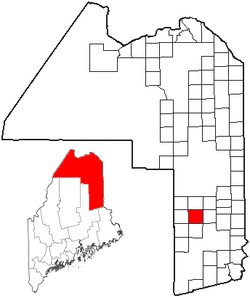
Coordinates: 46°4′53″N 68°12′45″W / 46.08139°N 68.2125°W Country United States State Maine County Aroostook Area - Total 38.5 sq mi (99.7 km2) - Land 38.5 sq mi (99.7 km2) - Water 0.0 sq mi (0.0 km2) Elevation 541 ft (165 m) Population (2010) - Total 213 - Density 5.2/sq mi (2.0/km2) Time zone Eastern (EST) (UTC-5) - Summer (DST) EDT (UTC-4) Area code(s) 207 FIPS code 23-19210 GNIS feature ID 0582449 Dyer Brook is a town in Aroostook County, Maine, United States. The population was 199 at the 2000 census. Dyer Brook is also host to the local school, Southern Aroostook Community School.
Geography
According to the United States Census Bureau, the town has a total area of 38.5 square miles (100 km2), of which, 38.5 square miles (100 km2) of it is land and 0.03% is water.
Demographics
As of the census[1] of 2000, there were 199 people, 79 households, and 62 families residing in the town. The population density was 5.2 people per square mile (2.0/km²). There were 116 housing units at an average density of 3.0 per square mile (1.2/km²). The racial makeup of the town was 97.49% White, 2.01% Native American and 0.50% Asian.
There were 79 households out of which 26.6% had children under the age of 18 living with them, 70.9% were married couples living together, 6.3% had a female householder with no husband present, and 21.5% were non-families. 10.1% of all households were made up of individuals and 2.5% had someone living alone who was 65 years of age or older. The average household size was 2.52 and the average family size was 2.71.
In the town the population was spread out with 19.1% under the age of 18, 4.5% from 18 to 24, 23.1% from 25 to 44, 35.7% from 45 to 64, and 17.6% who were 65 years of age or older. The median age was 46 years. For every 100 females there were 95.1 males. For every 100 females age 18 and over, there were 106.4 males.
The median income for a household in the town was $46,429, and the median income for a family was $46,429. Males had a median income of $40,000 versus $20,625 for females. The per capita income for the town was $18,658. About 2.9% of families and 5.5% of the population were below the poverty line, including 15.4% of those under the age of eighteen and none of those sixty five or over.
References
- ^ "American FactFinder". United States Census Bureau. http://factfinder.census.gov. Retrieved 2008-01-31.
Municipalities and communities of Aroostook County, Maine Cities 
Towns Allagash | Amity | Ashland | Bancroft | Blaine | Bridgewater | Castle Hill | Caswell | Chapman | Crystal | Dyer Brook | Eagle Lake | Easton | Fort Fairfield | Fort Kent | Frenchville | Grand Isle | Hamlin | Hammond | Haynesville | Hersey | Hodgdon | Houlton | Island Falls | Limestone | Linneus | Littleton | Ludlow | Madawaska | Mapleton | Mars Hill | Masardis | Merrill | Monticello | New Canada | New Limerick | New Sweden | Oakfield | Orient | Perham | Portage Lake | St. Agatha | St. Francis | Sherman | Smyrna | Stockholm | Van Buren | Wade | Wallagrass | Washburn | Westfield | Westmanland | Weston | Woodland
Plantations Unorganized
territoriesCDPs Fort Fairfield | Fort Kent | Houlton | Limestone | Loring AFB | Madawaska | Mars Hill-Blaine | Van Buren
Other
villagesCrouseville | Estcourt Station | Wytopitlock
Coordinates: 46°04′53″N 68°11′00″W / 46.08139°N 68.1833333°W
Categories:- Towns in Aroostook County, Maine


Wikimedia Foundation. 2010.