- Connor, Maine
-
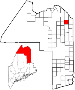
Connor is an unorganized territory (township) in Aroostook County, Maine, United States. The population was 424 at the 2000 census.
Geography
According to the United States Census Bureau, the unorganized territory has a total area of 39.5 square miles (102.3 km²), of which, 39.4 square miles (102.1 km²) of it is land and 0.1 square miles (0.2 km²) of it (0.23%) is water.
Demographics
As of the census[1] of 2000, there were 424 people, 162 households, and 127 families residing in the unorganized territory. The population density was 10.8 people per square mile (4.2/km²). There were 193 housing units at an average density of 4.9/sq mi (1.9/km²). The racial makeup of the unorganized territory was 97.88% White, 0.71% Native American, and 1.42% from two or more races.
There were 162 households out of which 35.2% had children under the age of 18 living with them, 64.2% were married couples living together, 4.9% had a female householder with no husband present, and 21.0% were non-families. 14.2% of all households were made up of individuals and 6.8% had someone living alone who was 65 years of age or older. The average household size was 2.62 and the average family size was 2.83.
In the unorganized territory the population was spread out with 26.4% under the age of 18, 4.5% from 18 to 24, 30.7% from 25 to 44, 28.3% from 45 to 64, and 10.1% who were 65 years of age or older. The median age was 39 years. For every 100 females there were 104.8 males. For every 100 females age 18 and over, there were 97.5 males.
The median income for a household in the unorganized territory was $25,417, and the median income for a family was $26,818. Males had a median income of $22,917 versus $18,182 for females. The per capita income for the unorganized territory was $12,748. About 5.9% of families and 11.8% of the population were below the poverty line, including 11.8% of those under age 18 and 23.3% of those age 65 or over.
References
- ^ "American FactFinder". United States Census Bureau. http://factfinder.census.gov. Retrieved 2008-01-31.
- "Township of Connor". Geographic Names Information System, U.S. Geological Survey. 1 September 1995. http://geonames.usgs.gov/pls/gnispublic/f?p=gnispq:3:::NO::P3_FID:582416. Retrieved 2010-04-13.
- "Unorganized Territory of Connor". Geographic Names Information System, U.S. Geological Survey. 11 February 2008. http://geonames.usgs.gov/pls/gnispublic/f?p=gnispq:3:::NO::P3_FID:2378259. Retrieved 2010-04-13.
Municipalities and communities of Aroostook County, Maine Cities 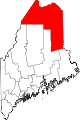
Towns Allagash | Amity | Ashland | Bancroft | Blaine | Bridgewater | Castle Hill | Caswell | Chapman | Crystal | Dyer Brook | Eagle Lake | Easton | Fort Fairfield | Fort Kent | Frenchville | Grand Isle | Hamlin | Hammond | Haynesville | Hersey | Hodgdon | Houlton | Island Falls | Limestone | Linneus | Littleton | Ludlow | Madawaska | Mapleton | Mars Hill | Masardis | Merrill | Monticello | New Canada | New Limerick | New Sweden | Oakfield | Orient | Perham | Portage Lake | St. Agatha | St. Francis | Sherman | Smyrna | Stockholm | Van Buren | Wade | Wallagrass | Washburn | Westfield | Westmanland | Weston | Woodland
Plantations Unorganized
territoriesCentral Aroostook | Connor | Northwest Aroostook | South Aroostook | Square Lake
CDPs Fort Fairfield | Fort Kent | Houlton | Limestone | Loring AFB | Madawaska | Mars Hill-Blaine | Van Buren
Other
villagesCrouseville | Estcourt Station | Wytopitlock
Categories:- Populated places in Aroostook County, Maine
- Unorganized territories in Maine


Wikimedia Foundation. 2010.