- Mongkol Borei District
-
Mongkol Borei
ស្រុកមង្គលបុរី— District (srok) — Map showing the location of the district within Banteay Meanchey Province.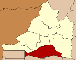 Location in Cambodia
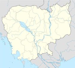
 Mongkol Borei
Coordinates: 13°32′30″N 103°1′30″E / 13.54167°N 103.025°E Country  Cambodia
Province Banteay Meanchey Communes 13 Villages 157 Population (1998)[1] – Total 138,190 Time zone +7 Geocode 0102 Mongkol Borei District (Khmer: ស្រុកមង្គលបុរី) is a district (srok) in the south of Banteay Meanchey Province, in north-western Cambodia. The district capital is Mongkol Borei town located around 8 kilometres south of the provincial capital of Sisophon by road. Mongkol Borei District is the southern-most district of Banteay Meanchey. The district shares a border with Battambang Province to the south. The main railway line from Phnom Penh to Poipet on the border with Thailand runs through the district from north to south.[2]
The district is easily accessed by road from Sisophon (8 km) Battambang (city) (60 km) and Siem Reap (city) (110 km). Mongkol Borei District is one of the smallest districts in Banteay Meanchey province by land area and only Serei Saophoan District is smaller. However, it has the largest district population in the province due to its central location and transport infrastructure. National Highway 5 which begins in Phnom Penh and ends at Poipet and the National railway bisect the district in parallel running from north to south. National road 160 begins near the centre of the district and runs south west into Pailin.[3]
Contents
History
The history of Mongkul Borei district before the 18th century is unclear, although it is likely that it was part of Battambang Province. From the 18th century until 1907, it was part of Phra Tabong Province of Thailand. At that time the Thai controlled the area that is modern Banteay Meanchey, Oddar Meanchey, Siem Reap, Pailin and Battambang provinces.[4]Under the French-Siamese treaty of March 23, 1907, these parts of Cambodia were returned. At this time the area around Serei Sophorn was part of Serei Sophorn district of Battambang. Between 1925 and 1940 a number of new Battambang districts were created, including Mongkol Borei. In 1988 the five northern districts of Battambang were separated to form the new province of Banteay Meanchey.[5]
Location
Mongkol Borei district lies in the south of the province and shares a border with Battambang Province. Reading from the north clockwise, Mongkol Borei borders with Serei Saophoan district to the north. The eastern border of the district is shared with Preah Netr Preah district. The Mongkol Borei River forms part of the eastern district boundary towards Preah Netr Preah.[6] To the south the district shares a border with Thmor Koal and Bavel districts of Battambang province. The western border of the district joins with Malai and Ou Chrov districts of Banteay Meanchey.[7]
Administration
The Mongkol Borei district governor reports to His Excellency Oung Ouen, the Governor of Banteay Meanchey. The following table shows the villages of Mongkol Borei district by commune.
Khum (Communes) Phum (Villages) Geocode Banteay Neang Ou Thum, Phnum, Banteay Neang, Kouk Pnov, Trang, Pongro, Kouk Tonloab, Trabaek, Khile, Samraong Pen, Dang Run Lech, Dang Run Kaeut, Ou Snguot, Prey Changha Lech, Prey Changha Kaeut, Ou Andoung Lech, Ou Andoung Kandal, Ou Andoung Kaeut, Kouk Kduoch 010201 Bat Trang Khtum Reay Lech, Khtum Reay Kaeut, Anlong Thngan Kaeut, Anlong Thngan Lech, Bang Bat Lech, Bang Bat Kaeut, Bat Trang, Bat Trang Thum Lech, Bat Trang Thum Kaeut, Bang Bat Touch, Preaek Chik 010202 Chamnaom Pralay Char, Rongvean Lech, Rongvean Kaeut, Chamnaom Lech, Chamnaom Kaeut, Roung Kou Daeum, Roung Kou Kandal, Roung Kou Chong, Peam Roung kou, Ta Sal, Chuor Khchas, Boeng Tras, Dang Trang, Srae Prey, Bos Tonloab, Ta Bun, Kouk Ponley, Say Samon, Damnak Preas Ang 010203 Kouk Ballangk Kouk Ballangk, Ta An, Pralay Chrey, Cheung Chab, Phat Sanday, Char Thmei, Ph'av Thmei, Ta Sal 010204 Koy Maeng Koy Maeng, Sdei Leu, Phlov Siem, Ta Nong, Angkar Khmau, Kasang Thmei, Stueng Chas, Sdei Kraom 010205 Ou Prasat Phnum Thum Tboung, Phnum Prasat, Phnum Thum Cheung, Chamkar Louk, Phnum Thum Thmei, Anlong Sdei, Kouk Thnong Kaeut, Kouk Thnong Kandal, Ou Snguot, Ou Prasat, Kouk Ampil, Ra Chamkar Chek, Pou Rieng, Rung Krabau 010206 Phnum Touch Phnum Touch Tboung, Phnum Touch Cheung, Thnal Bat, Ou Nhor, Boeng Tras, Monourom, Paoy Ta Sek, Prey Totueng, Boeng Reang, Voat Thmei 010207 Rohat Tuek Pou Pir Daeum, Rohat Tuek, Thnal Bat, Kramol, Khtum Chrum, Chak Lech, Doun Mul, Preaek Samraong, Ou Dangkao, Chamkar Chek, Ou Chuob, Ka Svay, Chak Kaeut 010208 Ruessei Kraok Anhchanh, Neang Ket, Praek Ropou, Sala Daeng, Samraong, Anlong Mean Trop, Chamkar Ta Daok, Pralay Luong Kraom, Luong, Ou Ta Kol, Pralay Luong Leu, Kouk Svay, Ou Ta Ma, Kaoh Kaev, Phasi Sra, Ruessei Kraom, Chumteav 010209 Sambuor Chhnaeum Meas, Sranal, La, Ta Meaeng Pok, Sambuor, Doun Loek, Kbal Krabei, Srah Chhuk, Srae Prey, Chaek Angkar, Thma Dab 010210 Soea Ta Mau, Ansam Chek, Tnaot, Buor, Bos Laok, Soea, Boeng Touch, Phlov Damrei Leu, Phlov Damrei Kraom, Ou Soea, Kouk Samraong, Balang Chrey, Ou Choub Thmey 010211 Srah Reang Ta In Muoy, Ta In Pir, Krouch, Chamkar Chek, Srah Reang, Ta Chan, Kouk Srok, Kouk Chrab, Kouk Krasang 010212 Ta Lam Preah Srae, Ta Lam Kandal, Ta Lam Chong, Boeng Khleang Lech, Chong Kouk, Boeng Khleang Kaeut, Khla Kham Chhkae, Boeng Veaeng 010213 Demographics
The district is subdivided into 13 communes (khum) and 157 villages (phum).[8] According to the 1998 Census, the population of the district was 138,190 persons in 25,754 households in 1998. This population consisted of 67,821 males (49.1%) and 70,369 females (50.9%). With a population of over 130,000 people, Mongkol Borei has by far the largest district populations in Banteay Meanchey province. The average household size in Mongkol Borei is 5.4 persons per household, which is slightly larger than the rural average for Cambodia (5.2 persons). The sex ratio in the district is 96.4%, with slightly more females than males.[9]
References
- ^ General Population Census of Cambodia, 1998: Village Gazetteer. National Institute of Statistics. February, 2000. pp. 1–4.
- ^ Total Road Atlas of Cambodia 2006 (3rd edition ed.). Total Cambodge. 2006. pp. 33.
- ^ Cambodia Road Network (Version 03-00 ed.). Ministry of Public Works and Transport. 2001.
- ^ "Background of Battambang In the past and the present". Battambang Provincial Government. http://www.battambang-town.gov.kh/city_info/anzeige/redaktionssystem/main/show.cfm?region_id=27&lang_id=3&id=253&modul_id=5. Retrieved 2009-02-20.
- ^ "Background of Battambang In the past and the present". Battambang Provincial Government. http://www.battambang-town.gov.kh/city_info/anzeige/redaktionssystem/main/show.cfm?region_id=27&lang_id=3&id=253&modul_id=5. Retrieved 2009-02-22.
- ^ "Stung Mongkol Borei Sub-Basin". Asian Development Bank. http://www.adb.org/Projects/Tonle_Sap/atlas/profile.asp?sub=4.
- ^ "Banteay Meanchey Provincial Resources". Ministry of Commerce. http://www.moc.gov.kh/national_data_resource/Provincial%20Resources/Banteay%20Meanchey/Index.htm. Retrieved 2009-02-15.[dead link]
- ^ "Banteay Meanchey Administration". Royal Government of Cambodia. http://www.cambodia.gov.kh/unisql1/egov/english/province/banteay_meanchey.html. Retrieved 2009-01-22.
- ^ General Population Census of Cambodia, 1998: Village Gazetteer. National Institute of Statistics. February, 2000. pp. 1–15.
External links
- Banteay Meanchey at Royal Government of Cambodia website
- Banteay Meanchey at the Ministry of Commerce website
 Banteay Meanchey ProvinceCapital: Sisophon
Mongkol Borei District Banteay Neang · Bat Trang · Chamnaom · Kouk Ballangk · Koy Maeng · Ou Prasat · Phnum Touch · Rohat Tuek · Ruessei Kraok · Sambuor · Soea · Srah Reang · Ta Lam
Phnum Srok District Preah Netr Preah District Ou Chrov District Serei Saophoan District Svay Chek District Thma Puok District Malai District Categories:- Districts of Cambodia
- Banteay Meanchey Province
- Mongkol Borei District


Wikimedia Foundation. 2010.