- Petaluma, California
Infobox Settlement
official_name = City of Petaluma
other_name =
native_name =
nickname =
settlement_type =City
motto =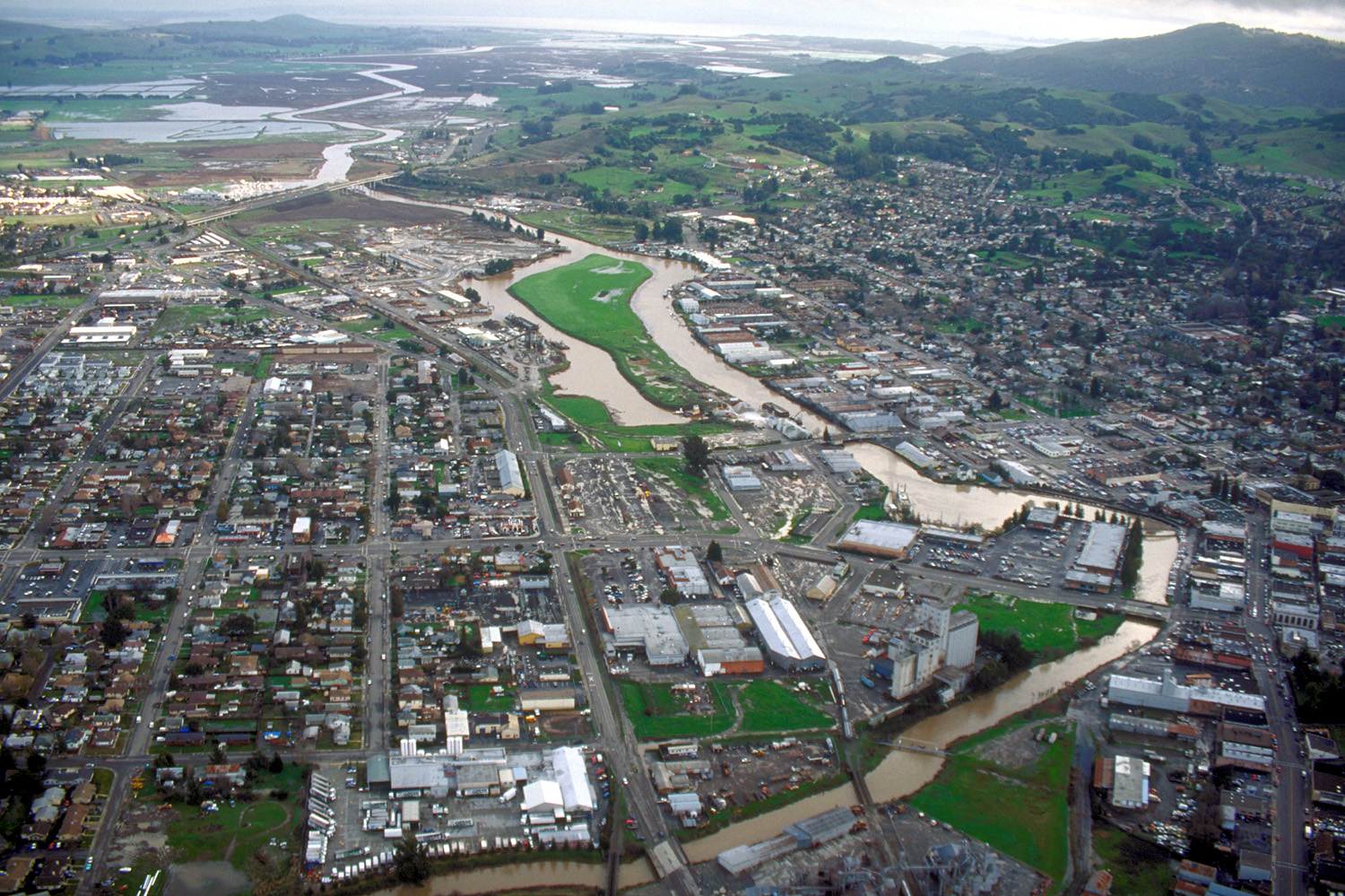
imagesize = 250px
image_caption = Aerial view of Petaluma, Ca. View is to the southeast
flag_size =
image_
seal_size =
image_shield =
shield_size =
image_blank_emblem =
blank_emblem_type =
blank_emblem_size =
flag_size =
image_
seal_size =
image_shield =
shield_size =
image_blank_emblem =
blank_emblem_type =
blank_emblem_size =
mapsize = 250x200px
map_caption = Location in Sonoma County and the state ofCalifornia
mapsize1 =
map_caption1 =
image_dot_
dot_mapsize =
dot_map_caption =
dot_x =
dot_y =
pushpin_
pushpin_label_position =
pushpin_map_caption =
pushpin_mapsize =
subdivision_type = Country
subdivision_name =United States
subdivision_type1 = State
subdivision_name1 =California
subdivision_type2 = County
subdivision_name2 = Sonoma
subdivision_type3 =
subdivision_name3 =
subdivision_type4 =
subdivision_name4 =
government_footnotes =
government_type = Council-manager
leader_title =Mayor
leader_name = Pamela Torliatt
leader_title1 =Vice Mayor
leader_name1 = David Rabbitt
leader_title2 =
leader_name2 =
leader_title3 =
leader_name3 =
leader_title4 =
leader_name4 =
established_title =
established_date =
established_title2 =
established_date2 =
established_title3 = Incorporated
established_date3 =April 12 ,1858 cite web|url=http://www.cacities.org/resource_files/20457.IncorpDateLO.doc|title=Dates of incorporation|accessdate=2008-07-11]area_magnitude =
unit_pref =
area_footnotes =
area_total_km2 = 36
area_land_km2 = 35.7
area_water_km2 = 0.3
area_total_sq_mi = 13.9
area_land_sq_mi = 13.8
area_water_sq_mi = 0.1
area_water_percent = 0.72
area_urban_km2 =
area_urban_sq_mi =
area_metro_km2 =
area_metro_sq_mi =
area_blank1_title =
area_blank1_km2 =
area_blank1_sq_mi =
population_as_of = 2000
population_footnotes =GR|2
population_note =
population_total = 54548
population_density_km2 = 1515
population_density_sq_mi = 3924
population_metro =
population_density_metro_km2 =
population_density_metro_sq_mi =
population_urban =
population_density_urban_km2 =
population_density_urban_sq_mi =
population_blank1_title =
population_blank1 =
population_density_blank1_km2 =
population_density_blank1_sq_mi =
timezone = PST
utc_offset = -8
timezone_DST = PDT
utc_offset_DST = -7
latd = 38 |latm = 14 |lats = 45 |latNS = N
longd = 122 |longm = 37 |longs = 53 |longEW = W
elevation_footnotes =gnis|277575|Petaluma]
elevation_m = 9
elevation_ft = 30
postal_code_type =ZIP code s
postal_code = 94952, 94954
area_code = 707
blank_name = FIPS code
blank_info = 06-56784
blank1_name = GNIS feature ID
blank1_info = 277575
website = http://cityofpetaluma.net/
footnotes =Petaluma is a city in Sonoma County,
California , in theUnited States . It is estimated that the 2006 population was 54,660cite web|url=http://factfinder.census.gov/servlet/SAFFPopulation?_event=Search&_cityTown=petaluma&_lang=en&_sse=on&ActiveGeoDiv=geoSelect&pgsl=050&_submenuId=population_0|title=Population Finder: Petaluma city, California|publisher=U.S. Census Bureau|accessdate=2007-12-01]Located in Petaluma is the
Rancho Petaluma Adobe , aNational Historic Landmark . It was built beginning in 1836 by GeneralMariano Guadalupe Vallejo , thenCommandant of theSan Francisco Presidio . It was the center of a vast 66,000 acre (270-km²) ranch stretching from Petaluma Creek toSonoma Creek . Theadobe is considered one of the best preserved buildings of its era in Northern California."Petaluma" is a transliteration of the
Coast Miwok phrase "péta lúuma" which means "hill backside" [cite book|title=California Place Names: The Origin and Etymology of Current Geographical Names|first=Erwin Gustav|last=Gudde|coauthors=William Bright|year=1998|location=Berkeley | publisher=University of California Press|id=ISBN 0-520-21316-5|edition=Second Edition|pages=Pg. 287] and probably refers to Petaluma's proximity toSonoma Mountain .Petaluma has a well preserved, historic city centerKay Ransom, C. Michael Hogan, Ballard George et al., "Environmental Impact Report for the Petaluma General Plan", prepared by Earth Metrics Inc. for the city of Petaluma (1984),] which includes many buildings that survived the great 1906 earthquake.
Demographics
As of the
census GR|2 of 2000, there were 54,548 people, 19,932 households, and 14,012 families residing in the city. Thepopulation density was 3,953 people per square mile (1,526/km²). There were 20,304 housing units at an average density of 1,471/sq mi (568/km²). The racial makeup of the city was 84.16% White, 1.16% African American, 0.54% Native American, 3.91% Asian, 0.17% Pacific Islander, 6.08% from other races, and 3.98% from two or more races. 14.64% of the population were Hispanic.There were 19,932 households out of which 36.6% had children under the age of 18 living with them, 55.3% were married couples living together, 10.6% had a female householder with no husband present, and 29.7% were non-families. 22.6% of all households were made up of individuals and 9.1% had someone living alone who was 65 years of age or older. The average household size was 2.70 and the average family size was 3.16. The age distribution is: 26.2% under the age of 18, 7.2% from 18 to 24, 31.5% from 25 to 44, 24.1% from 45 to 64, and 11.0% who were 65 years of age or older. The median age was 37 years. For every 100 females there were 95.6 males. For every 100 females age 18 and over, there were 91.9 males.
The median
income for a household in the city was $61,679, and the median income for a family was $71,158. Males had a median income of $50,232 versus $36,413 for females. Theper capita income for the city was $27,087. About 3.3% of families and 6.0% of the population were below thepoverty line , including 6.2% of those under age 18 and 7.1% of those age 65 or over.History
The
Coast Miwok Indians resided in southern Sonoma County, and Petaluma was originally the name of a Miwok village east of the Petaluma River. A number of other Coast Miwok villages were also located in and around what is now Petaluma; Wotoki, immediately to the south of the village of Petaluma, on the opposite side of the river, Etem, Likatiut, and Tuchayalin, near downtown Petaluma, and Tulme and Susuli, just north of what are now the city limits of Petaluma. [Peterson, Bonnie J. (1976). "Dawn of the World: Coast Miwok Myths". ISBN 0-912908-04-1]Pioneered by the Spanish in 1776, the Petaluma area was part of a 66,000 acre (270-km²) Mexican land grant of 1844 by Governor
Pío Pico to GeneralMariano Guadalupe Vallejo called the "Rancho Soscol". In 1836, General Vallejo began construction of hisRancho Petaluma Adobe a ranch house in Petaluma, which his family often used as a summer home, while he resided in the neighboring town of Sonoma. Vallejo's influence and Mexican control in the region began to decline after Vallejo's arrest during the Bear Flag Revolt in 1846.Pioneers flocked into Petaluma from the eastern United States after the discovery of gold in California in 1849. The town's position on the Petaluma River in the heart of productive farmland was critical to its growth during the 19th and early 20th centuries. Sailing
scows , such as the scowschooner Alma (1892) , and steamers plied the river between Petaluma and San Francisco, carrying agricultural produce and raw materials to the burgeoning city ofSan Francisco during theCalifornia Gold Rush .Volpi's is an old
speakeasy that now operates as a bar and restaurant. There were also brothels, one of which is now Old Chicago Pizza on Petaluma Boulevard North, which used to be the main thoroughfare until US Highway 101 was constructed in the 1950s.Petaluma soon became known for its grain milling and chicken processing industries, which continue to the present as a smaller fraction of its commerce. At one time, Petaluma was known as the "Egg Capital of the World", sparking such nicknames as "Chickaluma". Petaluma hosted the only known Poultry drugstore and is the place where the egg incubator was invented by Lyman Byce in 1879.
In fact one of the largest historic chicken processing plants still stands in the central area of town; this 1930s brick building is no longer used for the chicken industry, but is being evaluated for preservation and change of use. Even though it is no longer known as the Egg Capital of the World, Petaluma maintains a strong agricultural base today with dairy farms, olive groves, vineyards, berry and vegetable farms. The city is proud to protect its Greenbelt of farmland.
According to the Army Museum at the Presidio, San Francisco, Petaluma was relatively unharmed during the San Francisco earthquake of
April 18 1906 , due to significant investment of stable bedrock underlying the region. As one of the few communities in the region left standing after the earthquake, Petaluma was the staging point for most Sonoma County rescue and relief efforts.Petaluma is today the location of many distinguished, well-preserved pre-1906 buildings and Victorian homes on the western side of the river. The downtown has suffered many river floods over the years and during the Depression commerce declined. A lack of funds prevented the demolition of the old homes and buildings. In the 1960s there was a counter-culture migration out of San Francisco into Marin County and southern Sonoma County, looking for inexpensive housing in a less urban environment. The old Victorian, Queen Anne and Eastlake houses were dusty gems waiting to be discovered and restored. Historic iron-front buildings in the downtown commercial district were also rescued. Traffic and new home development for the most part was rerouted to the east of downtown by the construction of the 101 freeway. With its large stock of historic buildings, Petaluma has been used as the filming location for numerous movies set in the 1940s, '50s, and '60s (see list of movies below). The historic McNear Building is a common film location.
Petaluma pioneered the time-controlled approach to development. Because of the region's soaring population in the sixties, the city enacted the “Petaluma Plan” in 1971. This plan limited the number of building permits to 500 annually for a five year period beginning in 1972. At the same time Petaluma created a redbelt around the town as a boundary for urban expansion for a stated number of years. Similar to
Ramapo, New York , a Residential Development Control System was created to distribute the building permits based on a point system conforming to the city's general plan to provide for low and moderate income housing and divide development somewhat equally between east and west and single family and multi-family housing.The stated objectives of Petaluma's time controlled growth management were to ensure orderly growth; to protect the city's small town character and surrounding green space; to provide a variety of housing choices; and to maintain adequate water supply and sewage treatment facilities.
The controlled development plan attracted national attention in 1975 when the city was taken to court by the Construction Industry Association. The city's restriction was upheld by the 9th Circuit Court in 1975 and the Supreme Court denied a Petition for Writ of
Certiorari in 1976.In the late 1990s, Petaluma was also known as
Telecom Valley due to the telecomstartup companies that seemed to multiply from one another, and offer great riches if you were lucky enough to be an early stockholder or employee. One success story was that of the employees of Advanced Fibre Communications (AFC) (now Tellabs), orCerent , which was purchased by Cisco. Some Cerent employees went on to purchase thePhoenix Theater , a local entertainment venue, which was once an opera house.Petaluma has been notable in the tech world again recently, due to
Leo Laporte hosting hisTWiT.tv podcast network from a small cottage in the city.Fact|date=September 2008Geography and environmental factors
Petaluma is located at coor dms|38|14|45|N|122|37|53|W|city (38.245849, -122.631276).GR|1 It has a total area of convert|13.9|sqmi|km2|1|abbr=on. convert|13.8|sqmi|km2|1|abbr=on of that is land and the remaining convert|0.1|sqmi|km2|1|abbr=on is water. Water is 0.72% of the total area.GR|2
Petaluma enjoys a mild
Mediterranean climate.The
National Weather Service 's cooperative station in Petaluma had a record high temperature of convert|110|°F|°C|abbr=on on June 2, 1960. The record low temperature of convert|16|°F|°C|abbr=on was recorded on November 14, 1916, and December 14, 1932. The wettest year was 1998 with convert|45.93|in|mm and the dryest year was 1976 with convert|8.29|in|mm. The wettest month was February 1998 with convert|19.59|in|mm. The most rainfall in 24 hours was convert|4.29|in|mm on December 27, 2004. Although snow is rare in Petaluma, 1.5 inches fell in January 1916. [ [http://www.wrcc.dri.edu/summary/Climsmcca.html Central California ] ]Petaluma is situated at the northernmost navigable end of the
Petaluma River , a tidal estuary that snakes southward toSan Pablo Bay . Pollution levels in the river, once considerable, have improved in recent years. A significant amount of the city is in the river's flood plain, which overflows its banks every few years, particularly in the Payran neighborhood.Principal environmental noise sources are U.S. Route 101, Petaluma Boulevard, Washington Street and other major arteries. The number of residents that live in a zone of noise exposure greater than 60 CNEL is approximately 4,000.
Immediately to the southwest is Helen Putnam Regional Park, accessible from Chileno Valley Road. This park of convert|216|acre|km2|1|abbr=on has trails for hiking, cycling and horseback riding and is one of two parks named in honor of former mayor Helen Putnam who served from 1965-1979; the other is Putnam Plaza on Petaluma Boulevard. Lying above the city of Petaluma on the northwest flank of
Sonoma Mountain is theFairfield Osborn Preserve , a nature reserve with a diversity of nativeflora andfauna . Nearby to the southeast isTolay Lake , the site of prehistoric seasonal settlement byMiwok andPomo tribes. It is flanked by the unincorporated communities of Penngrove to the north and Lakeville to the south.Film locations
Ever since 1973, Petaluma has served as a location for many major films, including:
*"
American Graffiti " (1973) Sonoma shooting was at Old Adobe Road, Frates Road, Petaluma Blvd., Petaluma High School, and the downtown parking lot for the police car scene, (also San Rafael and Tamalpais High School in Marin County).
*"Heroes" (1977) Locations include Petaluma, California Petaluma Raceway.
*"Cujo" (1983) Locations include Petaluma,Santa Rosa and Mendocino.
*"Explorers" (1985) Locations include Petaluma.
*"Howard the Duck" (1986)
*"Peggy Sue Got Married " (1986) Locations at Santa Rosa High School and Petaluma.
*"Basic Instinct " (1992) 3 day shoot in Petaluma and Rohnert Park, with other scenes in Carmel and San Francisco.
*"Merlin's Shop of Mystic Wonder " (1996) Exterior of the titular shop is Kentucky St. This film is mostly known for being featured onMystery Science Theater 3000
*"Phenomenon (film) " (1996)
*"Max, 13 " (1997) 4 day shoot in Petaluma and 10 day shoot in Tomales
*"Inventing the Abbotts " (1997)
*"Flubber " (1997) church scene filmed partially at Open Door Christian church in Petaluma
*"Lolita" (1997)
*"Videoplasty " (1998) Concert footage of thefunk-metal outfitPrimus , shot at the Phoenix Theatre.
*"Pleasantville" (1998) filmed at intersection of Petaluma Boulevard and Western Ave.
*"Mumford" (1999)
*"The Hamiltons " (2005)
*"Molotov Alva " (2007)Military
U.S. Coast Guard
The
U.S. Coast Guard operates theChief Petty Officer Academy atTraining Center Petaluma just outside Petaluma, near Two Rock. The Academy trains seniornon-commissioned officers (Chief Petty Officer s) for both the U.S. Coast Guard and the U.S. Air Force.California National Guard
The
California National Guard operates an armed forces facility in Petaluma, at 580 Vallejo Street.Government
Local
The mayor of Petaluma is Pamela Torliatt,cite web|url=http://cityofpetaluma.net/cclerk/council.html|title=City Clerk's Office|accessdate=2008-01-15] a former City Councilwoman. The vice mayor is David Rabbitt. The other five council members are Mike Harris, Karen Nau, Mike O'Brien, Teresa Barrett, and Samantha Freitas. Freitas will serve on the council for a two year term as she was appointed to fill the remainder of Mayor Torliatt's term.
tate and Federal
In the state legislature Petaluma is located in the 3rd Senate District, represented by Democrat
Carole Migden , and in the 6th Assembly District, represented by DemocratJared Huffman . Federally, Petaluma is located inCalifornia's 6th congressional district , represented by DemocratLynn Woolsey .Education
There are two comprehensive high schools in Petaluma. They are
Petaluma High School andCasa Grande High School . Casa Grande High School has a notableAcademic Decathlon team, which has representedSonoma County for the last 23 years in the state-level competition. There is an annual football game between the two schools' teams known as the "Egg Bowl".Santa Rosa Junior College has a rapidly growing second campus on Sonoma Mountain Parkway, on the east side of town. There is also a Roman Catholic high school, St. Vincent de Paul High School. The campus of the unaccreditedInstitute of Noetic Sciences is also located in Petaluma.Transportation
Highway 101 is the main freeway through town. State Route 116 also runs through town as Lakeville Highway. Other major streets include East Washington Street, North and South McDowell Boulevards, and Petaluma Boulevard.
Petaluma is served by
Petaluma Transit ,Golden Gate Transit and bySonoma County Transit bus services.Notable events
Petaluma held the world
arm-wrestling championships from 1952 to 2003. (The championships were moved toReno, Nevada in 2004 due to a lack of sponsorship; the 2007 finals will be held inBulgaria .) In the comic stripPeanuts ,Snoopy aspired to be a champion arm-wrestler (or "wrist-wrestler", as they were then called) and was shown in a series of 1968 strips headed for Petaluma. Alas, Snoopy was disqualified, as he had no thumb. [http://www.armwrestling.com/history.html]Petaluma received national attention when 12-year-old
Polly Klaas was kidnapped from her home atknifepoint onOctober 1 ,1993 and laterraped andmurder ed byRichard Allen Davis . The community pulled quickly together to publicize the disappearance and to form thePolly Klaas Foundation for missing and exploited children.Petaluma was the location for an episode of Dateline's "
To Catch a Predator " where they arrested 29 men in three days.Fact|date=September 2008Notable residents
Notable past and present residents include:
*Mitchell Altieri , film director
*Lloyd Bridges , actor
*Clark Coolidge , poet
*Revik Delfin , musician
*Patrick Monahan , Lead singer ofTrain (band)
*Joe Enochs , soccer player ofVfL Osnabrück (Germany)
*Greg Errico , original Sly and The Family Stone drummer, rock and roll hall of fame inductee, and musical producer
*Jeff Gerstmann , Former Editor in Chief at Gamespot
*Jonny Gomes , baseball player of theTampa Bay Rays , born and raised in Petaluma
*Norman Greenbaum , singer songwriter
*Tommy Heath ofTommy Tutone , musician
*Anita Hoffman , wife of 1960s radicalAbbie Hoffman
*Brainerd Jones , Architect
*Pauline Kael , movie critic, born in Petaluma
*John Mark Karr , infamously falsely confessed to killingJonBenét Ramsey
*Polly Klaas , murder victim
*Gabby La La , musician
*Leo Laporte , Radio Host/Netcaster/Author
*Abe Levy , film director
*The Mommies , comedy duo
*Alex Navarro , Former Editor at Gamespot
*Dean Radin , parapsychologist, author
*Marta Randall , author
*Winona Ryder (Horowitz), actress
*Silver Tree , film writer/producer
*Lynn Woolsey , U.S. Congressional RepresentativePopular culture references
Every summer, Petaluma plays host to the
World's Ugliest Dog Contest .In the computer game "
Sim City 2000 ", "Petaluma" is frequently a neighbor to the city the player builds.The 2007
Michael Ondaatje novel "Divisadero " is partly set on a farm situated near Petaluma.Petaluma City Ballet was established in 1981 and is the only regional ballet company in the City of Petaluma and the Sonoma County area.
A musical piece called
And on the Seventh Day Petals Fell in Petaluma , inspired by a garden in Petaluma, was created byHarry Partch in 1963.In the episode of the television show "M*A*S*H" 'The Topper', character
B.J. Hunnicutt mentions a "Petaluma lumberjack festival."There is a Petaluma Winery in southern Australia with unknown association to the California city.
ee also
*
Petaluma Gap
*Petaluma Transit References
External links
* [http://cityofpetaluma.net official site]
* [http://www.downtownpetaluma.com downtown blog]
* [http://www.healthycommunity.info/docs/Petaluma%20Green%20Lane%20%20map%20%2011x17%20PDF%20%205-16-05.pdf bicycling map]
* [http://cityofpetaluma.net/genplan/ststps.html Petaluma 2004/05 General Plan]
* [http://www.michaelmagic.com/pageGalPetaluma2.html Historical and scenic photos of Petaluma] by Michael MaggidGeographic Location
Centre = Petaluma
North = Penngrove
Northeast =Sonoma Mountain
East =Rancho Petaluma Adobe
Southeast = Lakeville
South = Novato
Southwest =Laguna Lake
West = Two Rock
Northwest = Cotati
Wikimedia Foundation. 2010.