- Chichester (district)
-
Chichester District — Non-metropolitan district — Chichester shown within West Sussex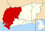
Sovereign state United Kingdom Constituent country England Region South East England Non-metropolitan county West Sussex Status Non-metropolitan district Admin HQ Chichester Incorporated 1 April 1974 Government - Type Non-metropolitan district council - Body Chichester District Council - Leadership Leader & Cabinet (Conservative) - MPs Nick Herbert
Francis Maude
Andrew TyrieArea - Total 303.6 sq mi (786.32 km2) Area rank 46th (of 326) Population (2010 est.) - Total 113,500 - Rank 191st (of 326) - Density 373.8/sq mi (144.3/km2) - Ethnicity 98.4% White Time zone GMT (UTC0) - Summer (DST) BST (UTC+1) Website chichester.gov.uk Chichester is a largely rural local government district in West Sussex, England. Its council is based in the city of Chichester.[1]
Contents
History
The district was formed on 1 April 1974, under the Local Government Act 1972, as a merger of the municipal borough of Chichester and the Rural Districts of Midhurst, Petworth and part of the former Chichester Rural District.
Governance
Chichester District Council has 48 councillors, representing 28 wards. Chichester itself has four of those wards (North, South, East and West); whilst the remaining ten wards comprise groups of villages. It is currently under Conservative control; as of the 3 May 2007 elections, the Conservatives held 34 seats, the Liberal Democrats held 11 seats and there were 3 independent councillors.[2]
Civil parishes
Main article: List of civil parishes in Chichester (district)There are 67 civil parishes in Chichester District. Apart from the City of Chichester, and the three towns of Midhurst, Selsey and Petworth, most are villages.
Geography
Chichester District occupies the western part of West Sussex, bordering on Hampshire to the west and Surrey to the north. The districts of Arun and Horsham abut to the east; the English Channel to the south. The district is divided by the South Downs escarpment, with the northern part being in the Weald, composed of a mixture of sandstone ridges and low lying clays known as the Western Weald. To the south the dip slope of the downs falls gently to a flat coastal plain and the sea. The Western Weald is drained by the River Arun and its tribituaries including the rivers Lox, Kird and especially the River Rother and its tribituaries the River Lod and the Haslingbourne Stream. On the northern boundary Blackdown is the highest point in Sussex, while further east around Loxwood the land is low and quite flat. The south of the district has many permeable chalk and gravel areas and is drained by two winterbournes, the River Lavant and River Ems, which are usually dry in the summer. The large inlet known as Chichester Harbour and the headland of Selsey Bill are conspicuous features of the coast.
The district, apart from the few main roads, is generally rural in character, as can be seen by the number of villages within it. Apart from the coastal strip there are few main roads, and the erstwhile railways which once served Midhurst have long been closed.
Landmarks
Apart from the geographical landmarks, Chichester District contains Chichester Cathedral, Goodwood Racecourse, Halnaker Windmill and Cowdray House a ruined Tudor mansion.
Economy
West Sussex County Council and Chichester District Council are major employers in Chichester, along with Rolls-Royce Motor Cars assembly plant at nearby Westhampnett. Boatbuilding is an important industry along the coast. Many people from the northern parts of the district commute to work in London, using the A3 road or the railways from Portsmouth to London Waterloo station and Littlehampton to London Victoria station. Fertile soils on the coastal plain are used for arable farming and intensive vegetable production, the latter employing many migrant workers from Eastern Europe. High sunlight levels and a mild climate also make the coastal region suitable for glasshouse growing. A fertile strip of land on the north side of the River Rother is also used for vegetable growing, but most of the area north of the Downs is of low agricultural value and there are large areas of forest and pasture, interspersed with arable cropping.
Football clubs
References
- ^ The dignity and privileges of the City of Chichester are vested in its town council, known as Chichester City Council, occupying only 10.6 km² of the total area of the District), which covers over 70 times the area
- ^ Notes on the District Council
Ceremonial county of West Sussex West Sussex Portal Boroughs or districts Adur District · Arun District · Chichester District · Crawley Borough · Horsham District · Mid Sussex District · Worthing Borough
Major settlements Arundel · Bognor Regis · Burgess Hill · Chichester · Crawley · East Grinstead · Haywards Heath · Horsham · Lancing · Littlehampton · Midhurst · Petworth · Selsey · Shoreham-by-Sea · Southwick · Steyning · Worthing
See also: List of civil parishes in West SussexRivers Topics History · Geography · (South Downs, South Downs National Park, Weald) · Museums · Places · Parliamentary constituencies · Schools
 Districts of South East England
Berkshire 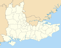
Buckinghamshire Aylesbury Vale • Chiltern • Milton Keynes • South Bucks • Wycombe
East Sussex Brighton & Hove • Eastbourne • Hastings • Lewes • Rother • Wealden
Hampshire Basingstoke and Deane • East Hampshire • Eastleigh • Fareham • Gosport • Hart • Havant • New Forest • Portsmouth • Rushmoor • Southampton • Test Valley • Winchester
Isle of Wight Kent Ashford • Canterbury • Dartford • Dover • Gravesham • Maidstone • Medway • Sevenoaks • Shepway • Swale • Thanet • Tonbridge and Malling • Tunbridge Wells
Oxfordshire Surrey Elmbridge • Epsom and Ewell • Guildford • Mole Valley • Reigate and Banstead • Runnymede • Spelthorne • Surrey Heath • Tandridge • Waverley • Woking •
West Sussex Categories:- 1974 establishments
- Local government in West Sussex
- Chichester (district)
- Non-metropolitan districts of West Sussex
- Local government districts of South East England


Wikimedia Foundation. 2010.