- U.S. Route 5
-
U.S. Route 5
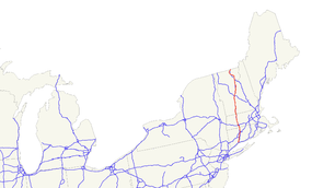
Route information Length: 300.34 mi[2][3][4] (483.35 km) Existed: 1926[1] – present Major junctions South end:  I-91 in New Haven, CT
 I-84 near Hartford, CT
 I-90 near Springfield, MA
 US 4 in White River Junction, VT
North end:  Route 143 in Stanstead, QC
Highway system United States Numbered Highways
List • Bannered • Divided • ReplacedU.S. Route 5 is a north–south United States highway running through the New England states of Connecticut, Massachusetts, and Vermont. Significant cities along the route include New Haven, Connecticut; Hartford, Connecticut; and Springfield, Massachusetts. From Hartford northward to St. Johnsbury, Vermont, the road closely follows the route of the Connecticut River.
The entire route of US 5 is closely paralleled by Interstate 91. US 5 now serves as the local business route for the Interstate highway. The northern terminus of US 5 is in Derby Line, Vermont at the Canadian border, where it continues into Quebec as Quebec Route 143, which was Route 5 until renumbered in the mid 1970s. Its southern terminus is in New Haven, Connecticut at an intersection with Interstate 91.[5]
Contents
Route description
Lengths mi km CT 54.59 87.85 MA 53.43 85.99 VT 192.32 309.50 Total 300.34 483.35 US 5 enters three states, Connecticut, Massachusetts, and Vermont, with the latter containing over half of US 5's total distance. Throughout nearly all of U.S. 5's entire length, it remains its own road entirely separate from Interstate 91, which has largely replaced it as a through route (and now carries most of the traffic). It is only co-signed onto I-91 for less than half of a mile in Springfield, MA, before splitting off alone again.
Connecticut
Main article: U.S. Route 5 in ConnecticutUS 5 begins in the city of New Haven, heading north through Hartford to Massachusetts. It generally parallels Interstate 91. From Meriden northward through Wethersfield, it runs concurrent with CT Route 15 and is known locally as the Berlin Turnpike. Much commerce is located there resulting in high traffic.[citation needed] The Berlin Turnpike leaves the roadway south of the Hartford city line.
After an interchange in Hartford with I-91, US Route 5/CT Route 15 travels over the Charter Oak Bridge, which spans the Connecticut River, into East Hartford. US Route 5 then splits off to head towards downtown East Hartford. It then has a short overlap with US Route 44, which joins it from the west as Connecticut Boulevard. US Route 44 continues to the east along Burnside Avenue as US Route 5 continues northward into South Windsor, East Windsor and Enfield. It leaves the state soon after a junction with I-91, heading into Longmeadow, Massachusetts (a part of the Springfield metro area).
Massachusetts
US 5 stays very close to the Connecticut River. It enters the state at the town of Longmeadow on the east bank of the river going up to Springfield. In Springfield, US 5 then overlaps with Interstate 91 for about 0.5 miles (0.80 km), then separates as its own freeway crossing the Connecticut River on the South End Bridge into Agawam. The freeway portion runs for about 3.3 miles (5.3 km) up to West Springfield. From the town of Northampton up to Bernardston, US 5 overlaps Route 10 (for 26 miles). US 5 goes through the following towns listed below. Access to Interstate 91 is indicated below each town where present. Junctions with major roadways are also indicated.
County Town Milepost Junction Notes Hampden Longmeadow 0.0 State line 1.8  Route 192
Northern terminus of Route 192 Springfield 3.5 Interstate 91Concurrency begins at I-91 Exit 1 3.7  Route 83
Northern terminus at I-91 Exit 2 3.9 Interstate 91Concurrency ends at I-91 Exit 3; US 5 crosses the North End Bridge Agawam 4.6  Route 57
Eastern terminus of Rte. 57 at rotary interchange with US-5 West Springfield 5.8  Route 147
Eastern terminus of Rte. 147 at rotary interchange with US-5
Access to Memorial Bridge to downtown Springfield7.0  U.S. Route 20
Rotary interchange 9.3 Interstate 91I-91 Exit 13 10.8 Interstate 90
Interstate 91I-90 Exit 4 & I-91 Exit 14 via shared entrance Holyoke 13.8  U.S. Route 202 West
Begin concurrency with US 202 Westbound 14.6  Route 141 East
Eastbound intersection only 14.8 Route 141 WestWestbound intersection only 15.0 U.S. Route 202 EastEnd concurrency with US 202 Westbound Hampshire Northampton 21.9 Interstate 91I-91 Exit 18 22.9 
 Route 9/Route 10
Begin concurrency with Route 10 24.3 Interstate 91I-91 Exit 20 – southbound exit, northbound entrance 26.1 Interstate 91I-91 Exit 21 – Southbound access; northbound access on Elm Street Hatfield 28.5 Interstate 91I-91 Exit 22 – Southbound onramp 28.8 Interstate 91I-91 Exit 22 – Northbound offramp Franklin Whately 30.5 Interstate 91I-91 Exit 23 – Northbound entrance 31.2 Interstate 91I-91 Exit 23 – Southbound exit 33.7 Interstate 91I-91 Exit 24 - No exit from southbound 33.9  Route 116
Begin triple concurrency Deerfield 34.8 Route 116End triple concurrency 41.0 Deerfield River Bridge - Entering Greenfield Greenfield 42.5  Route 2A
Court Square, site of historic road marker 44.2  Route 2
Four-way exit from Route 2; close access to I-91 Exit 27 Bernardston 49.0 Route 10End concurrency with US 5 53.46 State Line; US 5 continues into Brattleboro, Vermont Vermont
US 5 follows the Connecticut River Valley from the southern border of Vermont, traveling along the west bank of that river until it reaches St. Johnsbury.
US 5 enters the state at the town of Guilford. It passes through the counties of (from south to north) Windham, Windsor, Orange, Caledonia, and Orleans. Near the town of St. Johnsbury, US 5 continues northward, following the Passumpsic River valley until it reaches Sheffield Heights. After crossing the heights, it follows the Barton River valley until it reaches Orleans. It then turns north-northwest and crosses the divide near the Airport Road in Irasburg and follows the Black River valley into Newport. US 5 ends at the Canadian border in the village of Derby Line, where the roadway continues into Canada as Quebec Route 143.
As in Connecticut and Massachusetts, US 5 has many interchanges with Interstate 91, with a total of 22 junctions over its 192-mile (309 km) length in the state. Below is a list of major junctions:
- Hartford (Windsor County)
- Interstate 89 (via Interstate 91)
- US 4
- Newbury (Orange County)
- US 302
- St. Johnsbury (Caledonia County)
- Interstate 93 (via Interstate 91)
- US 2
History

Prior to the U.S. Highway system, the route was designated as Route 2 of the New England road marking system that existed between 1922 and 1927. When US 5 was first commissioned, it took over the entirety of Route 2. In 1927, US 5 had still not been paved in Vermont. Paving in Vermont was completed by 1933.
Connecticut
Originally, the route began at the New Haven Green in downtown New Haven (at US 1). Between New Haven and North Haven, it originally ran east of the Quinnipiac River along modern-day Middletown Avenue (part of Route 17) and Route 103 (the modern alignment was then designated as US 5A).
In Hartford, US 5 passed by Central Row in the downtown area, entering the city via Maple Avenue and exiting on the Bulkeley Bridge with US 6.
The southern terminus of US 5 has been realigned several times. By 1938, US 5 bypassed downtown New Haven via the Prospect Hill, Dixwell and West River neighborhoods, ending at Davenport Avenue and Columbus Avenue.[1] In the mid 1950s, US 5 was instead routed through the Mill River neighborhood ending at East Street and Forbes Avenue.[2] The modern New Haven to North Haven designation was also in place around this time. When I-91 opened in the 1967, the alignment was truncated to its current terminus at Exit 5 of I-91.
Massachusetts
The Massachusetts Highway Commission noted in 1912 that between Longmeadow and Agawam, the traffic between the Pioneer Valley and Connecticut was heavier on the east side.[6]
The western route from Hartford to West Springfield, via what is now River Road in Agawam[7] and Route 159 in Connecticut, was designated US-5A.[8]
The main route, US-5, was originally designated to run on the east side of the river from Hartford into downtown Springfield, over the Memorial Bridge, along Memorial Avenue, up a four-lane Main Street, and then to Park Street (and Park Avenue going in the opposite direction), and up what is now Elm Street, to Riverdale Street. Riverdale Street at that time followed the northern part of the current Elm Street, and ended at Witch Path.
In 1938, due to congestion in the West Springfield town center, Route 5 was moved to a newly constructed bypass from the North End Bridge to East Elm Street, where it continued north along the modern Elm Street and Riverdale Road.[9]
In 1941-42, a four-lane highway was built from East Elm Street to the current Elm Street fork just south of Morgan Road. The designations of both Riverdale Road and Route 5 were moved to the new more easterly route.[10]
In 1952-53, construction was started on the modern four-lane highway from the new South End Bridge in Agawam to the existing bypass at the North End Bridge. Tunnels were built under the rotaries at the Memorial and North End Bridges so Route 5 traffic and local traffic would not intersect. In 1971, the Riverdale Road portion of Route 5 was upgraded to a divided highway, with the installation of a steel median, and in 1987-88, a new lane was added to accommodate the new Riverdale Shops at Daggett Drive.[10]
The 1953 Massachusetts Department of Public Works Master Plan would have relocated U.S. 5 between Morgan Road in West Springfield and Mount Tom in Holyoke to a right-of-way similar to the current path of Interstate 91, but this was never implemented.[11]
Vermont/New Hampshire
US 5 in Vermont mostly followed the New England Route 2 alignment when it was first designated. Minor deviations from the current route are found in the urban compacts of White River Junction, Burke Hollow, Coventry, and Derby Center.
From 1927 to 1929, US 5 was temporarily routed into New Hampshire along part of what is now New Hampshire Route 12 between North Walpole and Charlestown.[12] The US 5 designation was removed when the road opposite the Connecticut River in Vermont had been improved.[citation needed] In 1931, US 5 in Vermont was taken over by the state, which began paving the road. Over the years a few minor reroutings within populated centers have taken place. The current alignment was in place by 1975.
See also
- Route 103 (Connecticut)
- Route 159 (Connecticut) and Route 159 (Massachusetts)
- Berlin Turnpike
- Vermont Route 5A
- New England Interstate Routes
Bannered routes


- U.S. Route 5 Alternate (St. Johnsbury, Vermont)
- U.S. Route 5 Alternate (Derby, Vermont)
- U.S. Route 5 Alternate (Newport, Vermont)
References
- ^ US Highways From US 1 to US 830 Robert V. Droz
- ^ Connecticut DOT Route Log
- ^ Executive Office of Transportation - Office of Transportation Planning Roads
- ^ VTrans Route Log
- ^ Endpoints of US highways
- ^ US-5: A Highway To History
- ^ US-5: A Highway To History
- ^ US-5: A Highway To History
- ^ US-5: A Highway To History
- ^ a b US-5: A Highway To History
- ^ US-5: A Highway To History
- ^ north–south routes - US 1 to US 101 - Odd numbered highways
 Main U.S. Routes
1 2 3 4 5 6 7 8 9 10 11 12 13 14 15 16 17 18 19 20 21 22 23 24 25 26 27 28 29 30 31 32 33 34 35 36 37 38 40 41 42 43 44 45 46 48 49 50 51 52 53 54 55 56 57 58 59 60 61 62 63 64 65 66 67 68 69 70 71 72 73 74 75 76 77 78 79 80 81 82 83 84 85 87 89 90 91 92 93 94 95 96 97 98 99 101 163 400 412 425 Lists U.S. Routes • Bannered • Divided • Bypassed Browse numbered routes ←  Route 4
CT US 6  →
→←  Route 4
MA US 6 →←  VT 4A
VT 4AVT VT 5A  →
→←  NH 4A
NH 4ANH NH 9  →
→←  Route 1A
N.E. Route 2A  →Categories:
- U.S. Highway System
- U.S. Highways in Massachusetts
- U.S. Highways in Vermont
- New England Interstate Routes
- Transportation in Orleans County, Vermont
- Hartford (Windsor County)


Wikimedia Foundation. 2010.