- St Minver
-
Coordinates: 50°33′31″N 4°52′25″W / 50.5587°N 4.8735°W
St Minver Cornish: Sen Menvra 
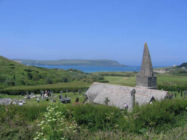
St Enodoc Church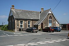
Perceval Institute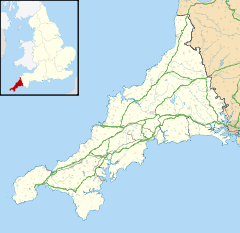
 St Minver
St Minver shown within CornwallPopulation 2,474 (Civil Parish, 2001) OS grid reference SW 965 771 Unitary authority Cornwall Ceremonial county Cornwall Region South West Country England Sovereign state United Kingdom Post town WADEBRIDGE Postcode district PL27 Dialling code 01208 Police Devon and Cornwall Fire Cornwall Ambulance South Western EU Parliament South West England UK Parliament North Cornwall List of places: UK • England • Cornwall St Minver (Cornish: Sen Menvra) is the name of an ecclesiastical parish, a civil parish and a village in north Cornwall, United Kingdom.
The civil parish of St Minver is in Bodmin Registration District and is nominally divided into St Minver Highlands (to the north and east) and St Minver Lowlands (to the west).
The combined parish is bounded on the south and west by the estuary of the River Camel, on the north by the Atlantic coast, and on the east by the parishes of St Endellion and St Kew. The population of the parish in the 2001 census was 2,474 (St Minver Highlands 1025; St Minver Lowlands 1449)
Contents
Settlements
The principal villages in the combined parish are the churchtown of St Minver, Rock, Trebetherick and Polzeath. Other settlements include Tredrizzick, Penmean, Splatt, Porthilly, Pityme and Trevanger.
St Minver village is centred on a small square at the crossroads of two unclassified roads. It is situated 3 miles (5 kilometres) north of Wadebridge a few hundred yards west of the B3314 Wadebridge to Delabole road.
Churches
The village of St Minver and its surrounding area is dominated by the tall spire of St Menefreda church (the parish church) named after Saint Menwreda (variously St Mynfreda or St Minefreda, the origin of the present day name St Minver) who was one of the 24 children of St Brychan. In the church is the brass of Roger Opy, 1517.[1]
There are two other churches in the parish, both in St Minver Lowlands.
- St Enodoc church is situated between Rock and Trebetherick at grid reference SW 931 772. It was built on towans (coastal sand dunes) in the fifteenth century and gradually became buried by the shifting sands. It was restored in the 1860s and now stands incongruously in the middle of a golf course. John Betjeman, the former poet laureate is buried in the churchyard.
- St Michael's church stands on the south shore of Porthilly Cove, an inlet of the River Camel just south of Rock, at SW 936 753. This church was also substantially restored in the 1860s.
Quaker Meeting House and burial grounds
There was formerly a meeting-house in this parish, with a cemetery belonging to the Quakers,. The walled Quaker burial ground at grid reference SW 955 778 near Treglines was used between 1665 to 1742 and twenty-eight burials are recorded.[2] The ground contains no headstones only trees. A small biographical tract was published in 1709, entitled " A Narrative of the Life and Sufferings of John Peters, a quaker, " who was buried in the quakers' burying ground at St Minver on the 7th July 1708:[3] this person was steward to the Carew family at Roserrow.[4] The walls of the burial ground have been listed by English Heritage.[5]
References
- ^ Dunkin, E. (1882) Monumental Brasses. London, Spottiswoode
- ^ Kelly's Directory 1939 Description of St Minver, Cornwall P238 to 240
- ^ A descriptive catalogue of Friends' books: By Joseph Smith
- ^ 'Parishes: Mevagissey - Mullion', Magna Britannia: volume 3: Cornwall (1814), pp. 227-244. URL: http://www.british-history.ac.uk/report.aspx?compid=50647 Date accessed: 16 October 2009.
- ^ English Heritage Listed Buildings with location map EH Reference 1211540
External links
- Ecclesiastical parish history
- Cornwall Record Office Online Catalogue for St Minver
- St Minver Lowlands Parish Council
Geography of Cornwall Unitary authorities Major settlements Bodmin • Bude • Callington • Camborne • Camelford • Falmouth • Fowey • Hayle • Helston • Launceston • Liskeard • Looe • Lostwithiel • Marazion • Newlyn • Newquay • Padstow • Par • Penryn • Penzance • Porthleven • Redruth • Saltash • St Austell • St Blazey • St Columb Major • St Ives • St Just-in-Penwith • St Mawes • Stratton • Torpoint • Truro • Wadebridge
See also: Civil parishes in CornwallRivers Topics History • Status debate • Flag • Culture • Places • People • The Duchy • Diocese • Politics • Hundreds/shires • Places of interest • full list...Civil parishes of North Cornwall constituency  Advent • Altarnun • Blisland • Bodmin • Boyton • Bude–Stratton • Camelford • Cardinham • Davidstow • Egloshayle • Egloskerry • Forrabury and Minster • Helland • Jacobstow • Kilkhampton • Laneast • Lanhydrock • Lanivet • Launceston • Launcells • Lawhitton Rural • Lesnewth • Lewannick • Lezant • Marhamchurch • Michaelstow • Morwenstow • North Hill • North Petherwin • North Tamerton • Otterham • Padstow • Poundstock • South Petherwin • St Breock • St Breward • St Clether • St Endellion • St Ervan • St Eval • St Gennys • St Issey • St Juliot • St Kew • St Mabyn • St Merryn • St Minver Highlands • St Minver Lowlands • St Stephens by Launceston Rural • St Teath • St Thomas the Apostle Rural • St Tudy • Stoke Climsland • Tintagel • Tremaine • Treneglos • Tresmeer • Trevalga • Trewen • Wadebridge • Warbstow • Week St Mary • Werrington • Whitstone • WithielCategories:
- Villages in Cornwall
- Civil parishes in Cornwall


Wikimedia Foundation. 2010.