- Tule River
-
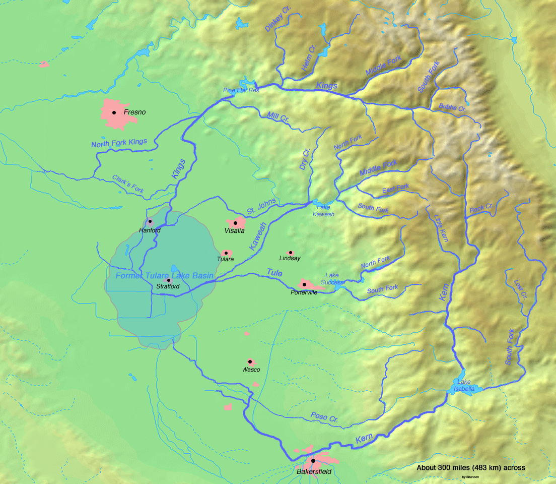
Tule River Rio San Pedro Country United States State California Part of Tulare Lake basin Tributaries - left Middle Fork Tule River - right North Fork Tule River, South Fork Tule River Cities Springville, Porterville, Tipton, Corcoran Source Confluence of North and Middle Forks - location Springville, Tulare County - elevation 1,037 ft (316 m) - coordinates 36°08′17″N 118°48′23″W / 36.13806°N 118.80639°W Mouth Tulare Lakebed - location Kings County - elevation 184 ft (56 m) - coordinates 36°02′59″N 119°49′27″W / 36.04972°N 119.82417°W Length 68.2 mi (110 km) Basin 400 sq mi (1,036 km2) Discharge for below Success Dam - average 197 cu ft/s (6 m3/s) - max 32,000 cu ft/s (906 m3/s) - min 0 cu ft/s (0 m3/s)  Map of streams and rivers in the Tulare Lake basin including the Tule River
The Tule River, also called Rio de San Pedro or Rio San Pedro,[1] is a river in Tulare County in the U.S. state of California. The river originates in the Sierra Nevada east of Porterville and consists of three forks, North, Middle and South. The North Fork and Middle Fork meet above Springville. The South Fork meets the others at Lake Success. Downstream of Success Dam, the river flows west through Porterville. The river used to empty into Tulare Lake, but its waters have been diverted for irrigation. However, the river does reach Tulare Lake during floods. Tulare Lake is the terminal sink of an endorheic basin that historically also received the Kaweah and Kern Rivers as well as southern distributaries of the Kings.
Contents
Course
North Fork
The North Fork, 19.0 miles (30.6 km) long,[2] begins high on a ridge facing south towards the Middle Fork Tule River drainage. It plunges madly southwest down a canyon in the Sequoia National Monument, then is joined at the same time by Kramer Creek and Backbone Creek as it enters a broader and less inclined valley. At Milo, the river turns southeast and parallels the Springville-Milo Road. Sycamore and Whitney Creeks join the river from the east and west, respectively, before it meets the Middle Fork at Springville.
Middle Fork
The 6.9-mile-long (11.1 km) Middle Fork[2] is formed by the confluence of the short South Fork Middle Fork Tule River and the North Fork Middle Fork Tule River. The South Fork flows northwest and west, paralleling California State Route 190, from its headwaters near Camp Nelson. The larger North Fork flows south from inside Sequoia National Park, plunges over North Fork of the Middle Fork of the Tule River Falls, and flows southwest to join the South Fork. After the confluence of the North and South forks, the Middle Fork Tule River flows more or less south and southwest, parallel to State Route 190, to join the North Fork and form the Tule River.
South Fork
The 27.7-mile-long (44.6 km) South Fork Tule River[2] joins the main Tule at Lake Success. Formed by the confluence of Blue Creek, Rocky Creek, Pigeon Creek and Bond Creek near Soda Springs, the river winds west-southwest through a narrow canyon. It then bends northwest, receiving Long Branch Creek from the left and Crew Creek from the right. It then forms an arm of Lake Success, which is crossed by State Route 190.
Mainstem
From the confluence, the Tule River flows about 10 miles (16 km) south and west, still following State Route 190, to Lake Success. Before emptying into the lake, it is joined by Campbell Creek from the north, and Graham Creek from the east. The South Fork of the Tule River joins the river in Lake Success. The river then exits the Success Dam and flows west into Porterville, and wind west to the former bed of Tulare Lake. It passes the cities of Tipton and Corcoran, and splits into many channels, eventually disappearing into multiple agricultural irrigation and drainage channels. The river terminates about 9 miles (14 km) east-northeast of Kettleman City in Kings County at a junction with a canal carrying water from the Kings River.
References
- ^ "Tule River". Geographic Names Information System, U.S. Geological Survey. 1981-01-19. http://geonames.usgs.gov/pls/gnispublic/f?p=gnispq:3:::NO::P3_FID:255800. Retrieved 2009-08-08.
- ^ a b c U.S. Geological Survey. National Hydrography Dataset high-resolution flowline data. The National Map, accessed March 15, 2011
Tulare Basin hydrography Kings River North Fork Kings River · South Fork Kings River · Middle Fork Kings River · Roaring River · Kings Canyon · Pine Flat Dam · Pine Flat Lake · Rodgers Crossing Dam (proposed)
Kaweah River North Fork Kaweah River · Middle Fork Kaweah River · Marble Fork Kaweah River · East Fork Kaweah River · South Fork Kaweah River · Lime Kiln Creek · Paradise Creek · Horse Creek · St. John's River · Kaweah Canyon · Mineral King · Terminus Dam · Lake KaweahTule River North Fork Tule River · Middle Fork Tule River · South Fork Tule River · North Branch Tule River · South Branch Tule River · Success Dam · Lake SuccessKern River Golden Trout Creek · Little Kern River · Rock Creek · South Fork Kern River · Canebrake Creek · Clear Creek · Poso Creek · Isabella Dam · Lake Isabella · Kern Canyon · Buena Vista Lake · Lake Webb · Lake Evans→Other Sacramento River Valley Pit River • McCloud River • Mill Creek • Deer Creek • Battle Creek •Stony Creek •Butte Creek • Feather River • Yuba River • Bear River • American River • Cache Creek • Putah CreekSan Joaquin River Valley Tulare Basin Categories:- Sierra Nevada (U.S.)
- San Joaquin Valley
- Rivers of Tulare County, California
Wikimedia Foundation. 2010.