- National Register of Historic Places listings in Winnebago County, Illinois
-
See also: List of Registered Historic Places in Illinois
Contents: List of Registered Historic Places in Winnebago County, Illinois, USA:
-
- This National Park Service list is complete through NPS recent listings posted November 10, 2011.[1]
Contents
Listings county-wide
Landmark name Image Date listed Location City or Town Summary 1 Barber-Colman Company Historic District August 8, 2006 100 Loomis, 1202–1322 (even) Rock Street
42°15′34″N 89°5′52″W / 42.25944°N 89.09778°WRockford 2 Beattie Park Mound Group 
February 27, 1991 North Main Street between Park and Mound Avenues
42°16′28″N 89°5′30″W / 42.27444°N 89.09167°WRockford 3 William Brown Building August 10, 2000 226–228 South Main Street
42°16′10″N 89°5′43″W / 42.26944°N 89.09528°WRockford 4 Chicago & North Western Railway Stone Arch Bridge August 19, 1993 0.6 miles (0.97 km) east of Illinois Route 251, 0.6 miles (0.97 km) west of Interstate 90 and 0.2 miles (0.32 km) south of Burr Oak Road
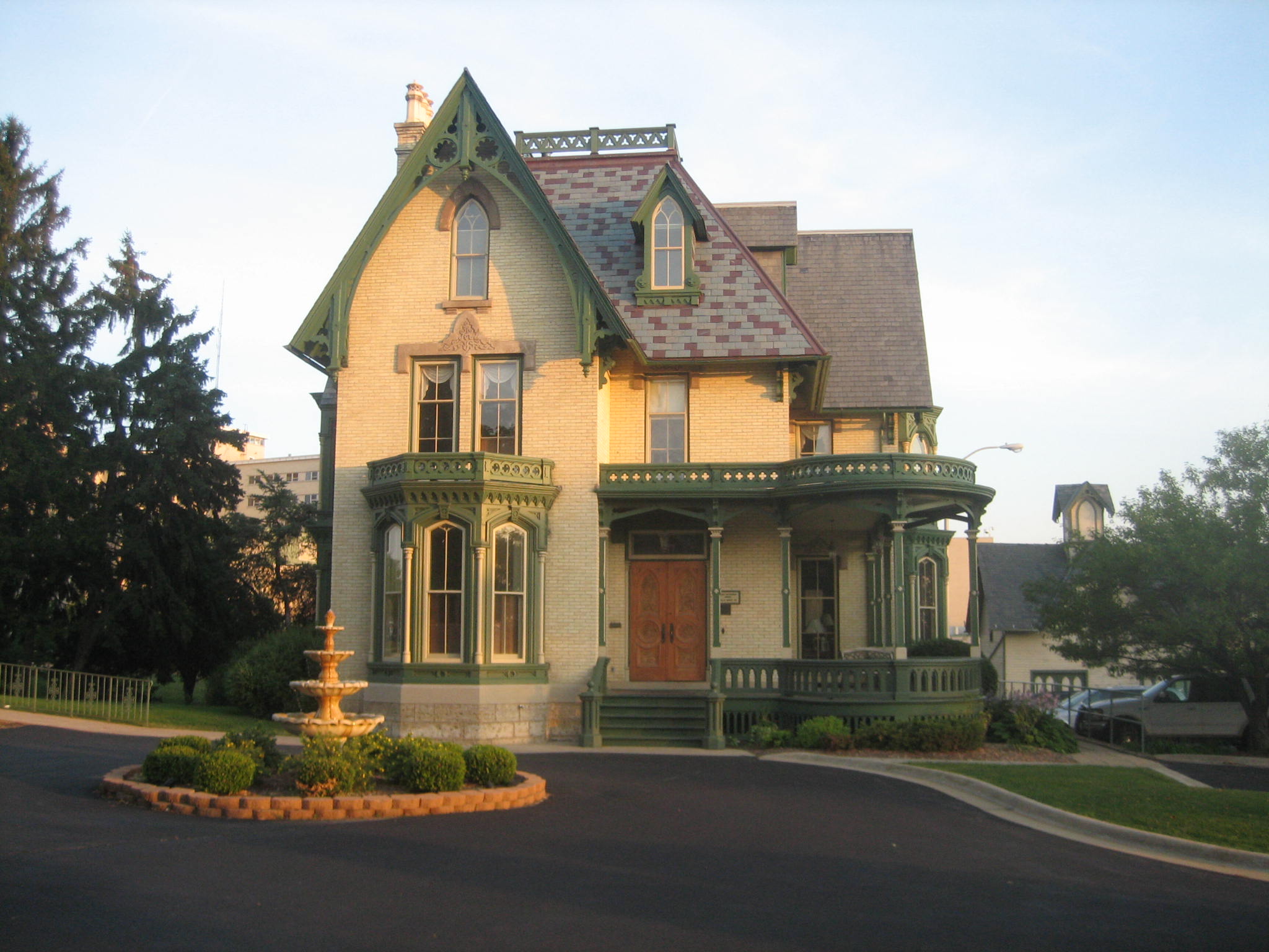
42°24′57″N 88°59′51″W / 42.41583°N 88.9975°WRoscoe Township 5 Chick House 
February 7, 1997 119–123 South Main Street
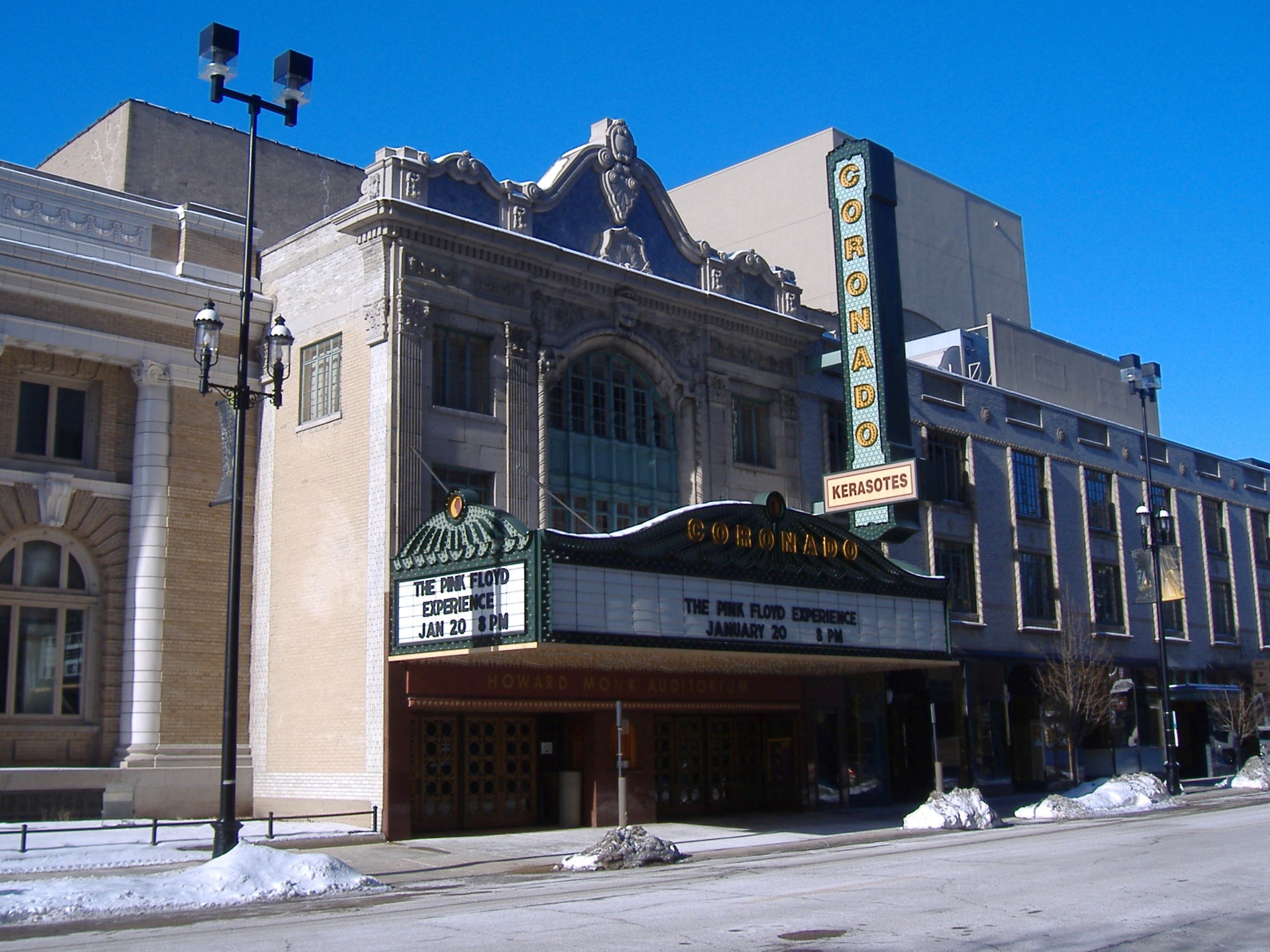
42°16′14″N 89°5′43″W / 42.27056°N 89.09528°WRockford 6 Coronado 
September 6, 1979 312–324 North Main Street
42°16′26″N 89°5′35″W / 42.27389°N 89.09306°WRockford 7 East Rockford Historic District March 20, 1980 U.S. Route 20 and U.S. Route 51
42°16′4″N 89°5′16″W / 42.26778°N 89.08778°WRockford 8 Garrison School 
February 9, 2006 1105 North Court Street
42°17′21″N 89°5′8″W / 42.28917°N 89.08556°WRockford 9 Graham-Ginestra House 
June 11, 1979 1115 South Main Street
42°15′42″N 89°6′2″W / 42.26167°N 89.10056°WRockford 10 Haight Village Historic District November 20, 1987 Roughly bounded by Walnut and Kishwaukee Streets, Chicago Northwestern railroad tracks and Madison Street
42°15′55″N 89°5′22″W / 42.26528°N 89.08944°WRockford 11 Herrick Cobblestone 
May 14, 1980 2127 Broadway
42°15′8″N 89°3′44″W / 42.25222°N 89.06222°WRockford 12 Illinois National Guard Armory 
August 10, 2000 605 North Main Street
42°16′37″N 89°5′22″W / 42.27694°N 89.08944°WRockford 13 Indian Hill Manor and Farm Historic District June 21, 2001 6901–7057 Kishwaukee Road
42°10′47″N 89°8′6″W / 42.17972°N 89.135°WRockford Township 14 Lysander Jacoby House March 5, 1982 2 Jacoby Place
42°17′14″N 89°3′45″W / 42.28722°N 89.0625°WRockford 15 H.D. Jameson House September 14, 2003 900 North Prairie Street
42°27′46″N 89°4′26″W / 42.46278°N 89.07389°WRockton 16 Lake-Peterson House 
June 25, 1980 1313 East State Street
42°16′1″N 89°4′28″W / 42.26694°N 89.07444°WRockford 17 Charles Lundberg House December 30, 2008 946 N. 2nd St.
42°16′44″N 89°4′40″W / 42.27889°N 89.07778°WRockford 18 Macktown Historic District January 5, 1978 West of Rockton on the Pecatonica River
42°27′0″N 89°5′17″W / 42.45°N 89.08806°WRockton 19 William H. Roberts House 
September 6, 1979 523 Main Street
42°18′43″N 89°21′35″W / 42.31194°N 89.35972°WPecatonica 20 Rockford Elk's Lodge No. 64 
February 28, 2005 210 West Jefferson
42°16′30″N 89°5′35″W / 42.275°N 89.09306°WRockford 21 Rockford Morning Star Building August 12, 1999 127 North Wyman Street
42°16′18″N 89°5′35″W / 42.27167°N 89.09306°WRockford 22 Rockton Historic District May 2, 1978 Roughly bounded by River, Warren, Cherry, and West Streets
42°27′11″N 89°4′23″W / 42.45306°N 89.07306°WRockton 23 Seventh Street Commercial Historic District March 23, 2005 Roughly bounded by 7th Street, Charles Street, 6th Street, Keith Creek
42°15′44″N 89°4′50″W / 42.26222°N 89.08056°WRockford 24 Soldiers and Sailors Memorial Hall 
January 31, 1976 211–215 North Main Street
42°16′21″N 89°5′35″W / 42.2725°N 89.09306°WRockford 25 Amos Catlin Spafford House 
February 20, 1980 501 North Prospect Street
42°16′21″N 89°3′58″W / 42.2725°N 89.06611°WRockford 26 Tinker Swiss Cottage 
December 27, 1972 411 Kent Street
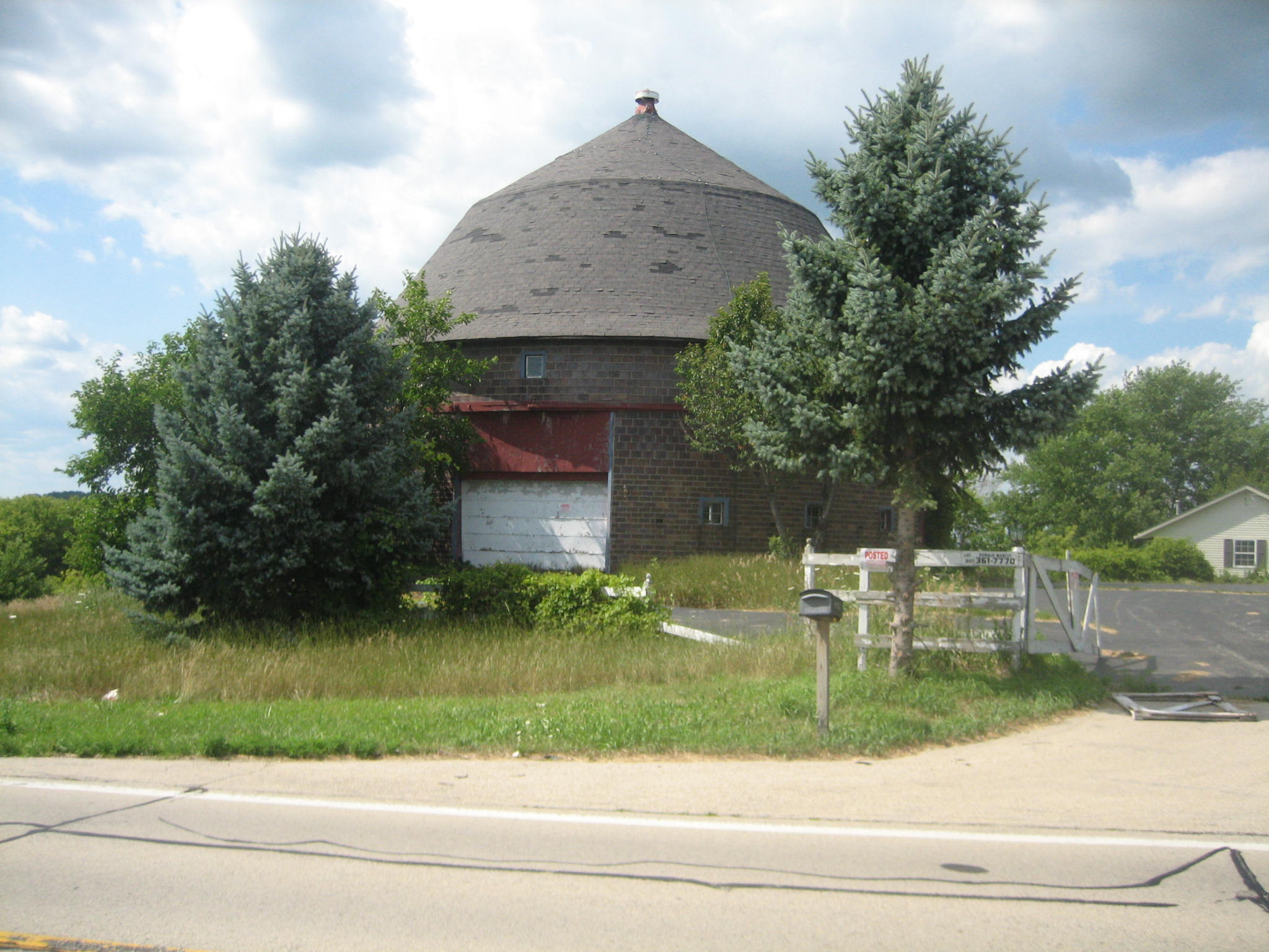
42°15′55″N 89°6′7″W / 42.26528°N 89.10194°WRockford 27 Robert Weber Round Barn 
February 23, 1984 East of Durand
42°24′44″N 89°14′11″W / 42.41222°N 89.23639°WHarrison Township 28 Valencia Court Apartments December 22, 2009 500-518 Fisher Ave.
42°16′45.87″N 89°5′31.82″W / 42.2794083°N 89.0921722°WRockford 29 West Downtown Rockford Historic District September 5, 2007 Roughly bounded by Park Avenue, State Street, Church Street, and Wyman Street
42°16′21.87″N 89°5′37.63″W / 42.2727417°N 89.0937861°WRockford 30 Ziock Building May 4, 2011 416 S. Main St
42°16′4″N 89°5′48″W / 42.26778°N 89.09667°WRockford See also
- List of Registered Historic Places in Illinois
- List of National Historic Landmarks in Illinois
References
- ^ "National Register of Historic Places: Weekly List Actions". National Park Service, United States Department of the Interior. Retrieved on November 10, 2011.
External links
- Winnebago County Listings at nationalregisterofhistoricplaces.com
U.S. National Register of Historic Places Topics Lists by states Alabama • Alaska • Arizona • Arkansas • California • Colorado • Connecticut • Delaware • Florida • Georgia • Hawaii • Idaho • Illinois • Indiana • Iowa • Kansas • Kentucky • Louisiana • Maine • Maryland • Massachusetts • Michigan • Minnesota • Mississippi • Missouri • Montana • Nebraska • Nevada • New Hampshire • New Jersey • New Mexico • New York • North Carolina • North Dakota • Ohio • Oklahoma • Oregon • Pennsylvania • Rhode Island • South Carolina • South Dakota • Tennessee • Texas • Utah • Vermont • Virginia • Washington • West Virginia • Wisconsin • WyomingLists by territories Lists by associated states Other Municipalities and communities of Winnebago County, Illinois Cities 
Villages Cherry Valley‡ | Durand | Machesney Park | New Milford | Pecatonica | Rockton | Roscoe | Winnebago
CDP Townships Unincorporated
communitiesFootnotes ‡This populated place also has portions in an adjacent county or counties
Categories:- Winnebago County, Illinois
- National Register of Historic Places in Illinois by county
- National Register of Historic Places in Winnebago County, Illinois
-


Wikimedia Foundation. 2010.