- National Register of Historic Places listings in Lincoln County, Maine
-
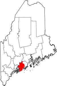 Location of Lincoln County in Maine
This is a list of the National Register of Historic Places listings in Lincoln County, Maine.
This is intended to be a complete list of the properties and districts on the National Register of Historic Places in Lincoln County, Maine, United States. Latitude and longitude coordinates are provided for many National Register properties and districts; these locations may be seen together in a Google map.[1]
There are 101 properties and districts listed on the National Register in the county, including 1 National Historic Landmark.
-
- This National Park Service list is complete through NPS recent listings posted November 10, 2011.[2]
Contents: Counties in Maine Androscoggin - Aroostook - Cumberland - Franklin - Hancock - Kennebec - Knox - Lincoln - Oxford - Penobscot - Piscataquis - Sagadahoc - Somerset - Waldo - Washington - York Current listings
[3] Landmark name[4] Image Date listed Location City or Town Summary 1 Alna Meetinghouse 
May 19, 1970 State Route 218
44°5′14″N 69°37′6″W / 44.08722°N 69.61833°WAlna Center 2 Alna School 
April 28, 1975 Alna Center
44°4′56″N 69°37′8″W / 44.08222°N 69.61889°WAlna 3 Arch Bridge July 7, 2003 Over the Pemaquid River on Benner Rd.
43°57′44″N 69°30′35″W / 43.96222°N 69.50972°WBristol 4 Archeological Site 16.8 June 29, 1984 Address Restricted Boothbay 5 Archeological Site 16.20 June 29, 1984 Address Restricted Boothbay 6 Archeological Site 16.21 June 29, 1984 Address Restricted Boothbay 7 Archeological Site 16.37 Area I and II June 29, 1984 Address Restricted Boothbay 8 Archeological Site 16.38 June 29, 1984 Address Restricted Boothbay 9 Archeological Site 16.47 June 29, 1984 Address Restricted Boothbay 10 Archeological Site 16.68 June 29, 1984 Address Restricted Boothbay 11 Archeological Site 16.73 May 29, 1984 Address Restricted Boothbay 12 Archeological Site 26.27 June 29, 1984 Address Restricted Boothbay 13 Archeological Site 16.175 June 29, 1984 Address Restricted Boothbay 14 Archeological Site 16.198 June 29, 1984 Address Restricted Boothbay 15 Auld-McCobb House June 28, 1988 Oak St.
43°51′8″N 69°37′42″W / 43.85222°N 69.62833°WBoothbay Harbor 16 Boothbay Harbor Memorial Library April 18, 1977 State Route 27
43°51′13″N 69°37′41″W / 43.85361°N 69.62806°WBoothbay Harbor 17 Bowman-Carney House 
April 7, 1971 Off State Route 197
44°5′35″N 69°46′35″W / 44.09306°N 69.77639°WDresden 18 Bremen Town Hall, Former April 14, 2000 State Route 32, 0.2 miles north of Medomak Rd.
44°0′47″N 69°25′18″W / 44.01306°N 69.42167°WMedomak 19 Brick House Historic District February 13, 2009 Address Restricted Newcastle 20 Bridge Academy January 9, 1987 State Routes 127 and 197
44°6′17″N 69°43′35″W / 44.10472°N 69.72639°WDresden 21 Burnt Island Light Station 
November 23, 1977 South of Boothbay Harbor on Burnt Island
43°49′31″N 69°38′28″W / 43.82528°N 69.64111°WBoothbay Harbor 22 Moses Carleton House July 18, 2002 Hollywood Boulevard 0.2 miles northeast of its junction with State Route 94
44°6′47″N 69°36′40″W / 44.11306°N 69.61111°WAlna 23 Chapman-Hall House May 19, 1970 Main and Vine Sts.
44°1′57″N 69°31′47″W / 44.0325°N 69.52972°WDamariscotta 24 Chimney Farm February 7, 2007 617 East Neck Rd.
44°05′03″N 69°29′09″W / 44.084225°N 69.485757°WNobleboro 25 Clary Mill December 2, 2004 104 Mills Rd.
44°13′42″N 69°35′3″W / 44.22833°N 69.58417°WWhitefield 26 Stephen Coffin House April 15, 1987 Main St.
44°1′57″N 69°31′53″W / 44.0325°N 69.53139°WDamariscotta 27 Congregational Church of Edgecomb June 12, 1987 Cross Point Rd.
43°59′7″N 69°38′47″W / 43.98528°N 69.64639°WNorth Edgecomb 28 CORA F. CRESSEY April 18, 1990 Keene Narrows
43°59′4″N 69°24′54″W / 43.98444°N 69.415°WBremen 29 Matthew Cottrill House 
May 2, 1974 Main St. (U.S. Route 1)
44°1′50″N 69°32′6″W / 44.03056°N 69.535°WDamariscotta 30 Cuckolds Light Station 
December 2, 2002 The Cuckolds
43°46′46″N 69°39′3″W / 43.77944°N 69.65083°WSouthport 31 Damariscotta Baptist Church June 20, 1985 King's Square
44°1′53″N 69°31′47″W / 44.03139°N 69.52972°WDamariscotta 32 Damariscotta Oyster Shell Heaps December 30, 1969 Address Restricted Damariscotta 33 Damariscotta Shell Midden Historic District 
October 8, 1998 Address Restricted Damariscotta 34 Damariscove Island Archeological Site May 22, 1978 Address Restricted Boothbay 35 Damariscove Lifesaving Station June 25, 1987 Damariscove Island
43°45′17″N 69°36′58″W / 43.75472°N 69.61611°WBoothbay 36 Dodge Point Site March 22, 1991 Address Restricted Newcastle 37 Dresden Brick School House June 13, 1986 State Route 128
43°43′30″N 69°46′11″W / 43.725°N 69.76972°WDresden 38 Dresden Town House October 12, 2000 391 Middle Rd.
44°5′8″N 69°44′37″W / 44.08556°N 69.74361°WDresden Mills 39 Fort Edgecomb 
October 1, 1969 On Davis Island in the Sheepscot River
43°59′37″N 69°39′26″W / 43.99361°N 69.65722°WEdgecomb 40 Fort William Henry 
December 1, 1969 Northwest of Pemaquid Beach
43°52′39″N 69°31′29″W / 43.8775°N 69.52472°WPemaquid Beach 41 German Church and Cemetery 
May 19, 1970 1 mile south of Waldoboro Village on State Route 32
44°6′8″N 69°25′17″W / 44.10222°N 69.42139°WWaldoboro 42 Glidden-Austin Block 
April 28, 1975 Junction of U.S. Route 1 and State Route 215
44°2′7″N 69°32′15″W / 44.03528°N 69.5375°WNewcastle 43 Old Gray House May 8, 2007 60 Tavenner Rd.
43°52′27″N 69°40′51″W / 43.87417°N 69.68083°WBoothbay 44 Harrington Meetinghouse May 19, 1970 Northwest of Pemaquid on Old Harrington Rd.
43°54′53″N 69°31′43″W / 43.91472°N 69.52861°WPemaquid 45 Head Tide Historic District 
November 19, 1974 Both sides of the Sheepscot River
44°6′53″N 69°37′28″W / 44.11472°N 69.62444°WAlna 46 Hendricks Head Light Station 
November 20, 1987 Hendricks Head on Southport Island
43°49′21″N 69°41′25″W / 43.8225°N 69.69028°WWest Southport 47 Anne Hilton Site July 13, 1989 Address Restricted Newcastle 48 Huston House February 8, 1985 Bristol Rd.
44°1′4″N 69°31′49″W / 44.01778°N 69.53028°WDamariscotta 49 Hutchins House February 19, 1982 77 Main St.
44°5′46″N 69°22′26″W / 44.09611°N 69.37389°WWaldoboro 50 The Influence December 29, 1983 Monhegan Island
43°45′49″N 69°19′17″W / 43.76361°N 69.32139°WMonhegan 51 Dr. F.W. Jackson House November 10, 1980 State Route 32
44°12′9″N 69°27′50″W / 44.2025°N 69.46389°WJefferson 52 Jefferson Cattle Pound July 28, 2004 0.75 miles west of the junction of Gardiner Rd. and State Route 213
44°12′1″N 69°29′48″W / 44.20028°N 69.49667°WJefferson 53 Jefferson Town House July 12, 1999 Junction of State Routes 126 and 213
44°12′2″N 69°29′6″W / 44.20056°N 69.485°WJefferson 54 Gov. Edward Kavanaugh House May 3, 1974 State Route 213 (Damariscotta Mills)
44°3′29″N 69°32′5″W / 44.05806°N 69.53472°WNewcastle 55 Rockwell Kent Cottage and Studio April 8, 1992 Off the northern side of Horn Hill Rd. on Monhegan Island
43°45′47″N 69°19′8″W / 43.76306°N 69.31889°WMonhegan 56 Knight-Corey House March 13, 1980 Corey Lane
43°52′35″N 69°38′9″W / 43.87639°N 69.63583°WBoothbay 57 Lithgow House December 26, 1985 Blinn Hill Rd.
44°6′36″N 69°43′5″W / 44.11°N 69.71806°WDresden 58 Loudville Church December 14, 1995 Center of Louds Island
43°55′49″N 69°26′7″W / 43.93028°N 69.43528°WLoudville 59 Godfrey Ludwig House September 22, 1980 State Route 32
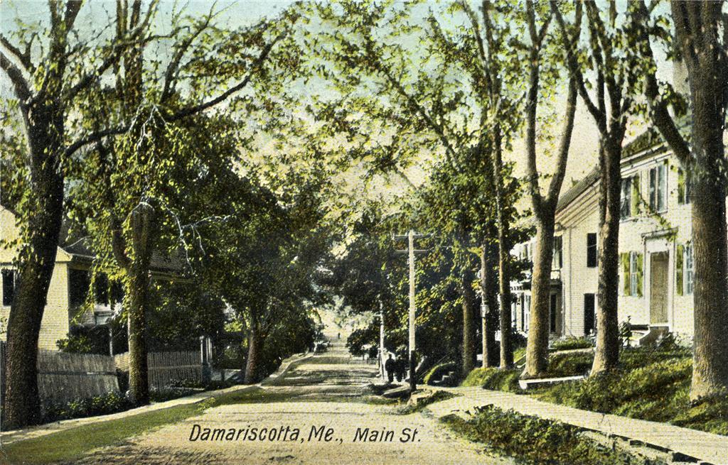
44°9′33″N 69°25′0″W / 44.15917°N 69.416667°WWaldoboro 60 Main Street Historic District 
August 10, 1979 Main St.; also 170-270 Main St. and 4-5 Bristol Rd.
44°1′58″N 69°31′56″W / 44.03278°N 69.53222°WDamariscotta Second set of addresses represents a boundary increase 61 Manana Island Fog Signal Station 
December 2, 2002 Manana Island
43°45′54″N 69°19′37″W / 43.765°N 69.32694°WMonhegan 62 Emily Means House February 8, 1985 Birch Island
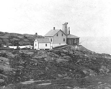
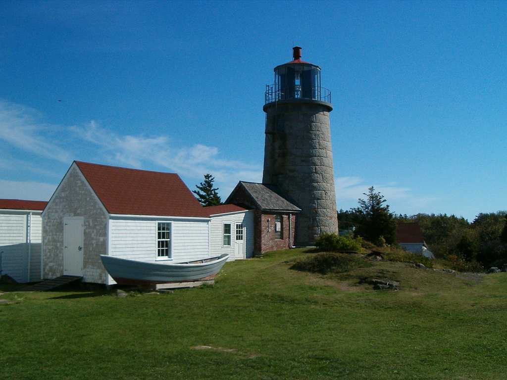
43°50′58″N 69°32′57″W / 43.84944°N 69.54917°WSouth Bristol 63 Monhegan Island Lighthouse and Quarters 
May 7, 1980 Monhegan Island
43°45′54″N 69°19′0″W / 43.765°N 69.316667°WMonhegan 64 John Moore House July 10, 1979 Southwest of Edgecomb on Cross Point Rd.
43°58′40″N 69°38′55″W / 43.97778°N 69.64861°WEdgecomb 65 Nahanada Village Site July 22, 1980 Address Unknown Bristol 66 Nickels-Sortwell House 
December 30, 1970 Northeastern corner of Main and Federal Sts.
44°0′15″N 69°40′3″W / 44.00417°N 69.6675°WWiscasset 67 Parson's Bend December 21, 2005 100 Nelson Rd.
44°5′55″N 69°36′0″W / 44.09861°N 69.6°WAlna 68 Josiah K. Parsons Homestead February 4, 1982 Greenleaf Cove Rd.
43°55′12″N 69°41′35″W / 43.92°N 69.69306°WWiscasset 69 Stephen Parsons House October 6, 1983 Southwest of Edgecomb on Parsons Creek
43°56′55″N 69°38′38″W / 43.94861°N 69.64389°WEdgecomb 70 Pemaquid Point Light 
April 16, 1985 Pemaquid Point
43°50′13″N 69°30′23″W / 43.83694°N 69.50639°WBristol 71 Pemaquid Restoration and Museum 
December 2, 1969 North of Pemaquid Beach at Pemaquid Point
43°52′41″N 69°31′17″W / 43.87806°N 69.52139°WPemaquid Beach 72 Pownalborough Courthouse 
January 12, 1970 Cedar Grove Rd.
44°6′19″N 69°45′59″W / 44.10528°N 69.76639°WDresden 73 Pythian Opera House December 30, 2008 86 Townsend Ave.
43°51′15.516″N 69°37′34.536″W / 43.85431°N 69.62626°WBoothbay Harbor 74 Ram Island Light Station 
January 21, 1988 Ram Island, Boothbay Harbor
43°48′14″N 69°36′0″W / 43.80389°N 69.6°WBoothbay Harbor 75 Red Brick School October 6, 1970 Warren St.
44°0′19″N 69°40′0″W / 44.00528°N 69.666667°WWiscasset 76 Co. Isaac G. Reed House August 5, 2005 60 Glidden St.
44°5′49″N 69°22′38″W / 44.09694°N 69.37722°WWaldoboro 77 Capt. George Scott House 
February 23, 1972 Federal St.
44°0′27″N 69°39′35″W / 44.0075°N 69.65972°WWiscasset 78 Second Congregational Church May 7, 1979 River St.
44°2′4″N 69°32′15″W / 44.03444°N 69.5375°WNewcastle 79 Sheepscot Historic District June 23, 1978 Address Restricted Newcastle 80 Sproul Homestead March 21, 1978 North of South Bristol on State Route 129
43°54′30″N 69°33′11″W / 43.90833°N 69.55306°WSouth Bristol 81 Squire Tarbox House April 11, 1985 State Route 144
43°54′5″N 69°42′30″W / 43.90139°N 69.70833°WWestport 82 St. Andrew's Church October 8, 1976 Glidden St.
44°2′3″N 69°32′4″W / 44.03417°N 69.53444°WNewcastle 83 St. Denis Catholic Church October 29, 1976 West of North Whitefield on State Route 218
44°13′43″N 69°36′52″W / 44.22861°N 69.61444°WNorth Whitefield 84 St. John's Anglican Church and Parsonage Site November 21, 1978 Address Restricted Dresden 85 St. John's Episcopal Church June 14, 1991 Southern side of State Route 27 at its junction with Blinn Hill Rd.
44°6′24″N 69°43′25″W / 44.10667°N 69.72361°WDresden Mills 86 St. Patrick's Catholic Church 
April 23, 1973 Academy Rd.
44°3′25″N 69°32′7″W / 44.05694°N 69.53528°WNewcastle 87 Taylor Site 16.65 June 29, 1984 Address Restricted Boothbay 88 Thompson Icehouse December 31, 1974 State Route 129
43°53′15″N 69°33′41″W / 43.8875°N 69.56139°WSouth Bristol 89 U.S. Customhouse (Old Customhouse) and Post Office 
August 25, 1970 Water St.
44°0′3″N 69°39′58″W / 44.00083°N 69.66611°WWiscasset 90 U.S. Customhouse and Post Office 
January 18, 1974 Main St.
44°5′44″N 69°22′33″W / 44.09556°N 69.37583°WWaldoboro 91 Union Church June 26, 1998 Eastern side of State Route 32, 0.05 miles south of its junction with Back Shore Rd.
43°56′49″N 69°27′40″W / 43.94694°N 69.46111°WRound Pond 92 Union Meeting House, (Former) July 15, 2002 Main Rd., State Route 144
43°53′55″N 69°42′34″W / 43.89861°N 69.70944°WWestport 93 Waldo Theatre September 11, 1986 Main St.
44°5′45″N 69°22′30″W / 44.09583°N 69.375°WWaldoboro 94 Waldoborough Town Pound May 28, 1976 Washington Rd.
44°5′59″N 69°22′15″W / 44.09972°N 69.37083°WWaldoboro 95 Walpole Meetinghouse 
November 7, 1976 North of Walpole on Meeting House Rd.
43°59′9″N 69°32′28″W / 43.98583°N 69.54111°WWalpole 96 Daniel Weston Homestead October 1, 1979 West of Medomak on State Route 32
44°0′6″N 69°25′43″W / 44.00167°N 69.42861°WMedomak 97 Westport Community Church July 15, 2002 Main Rd., State Route 144
43°53′57″N 69°42′34″W / 43.89917°N 69.70944°WWestport 98 Wetherill Site December 17, 1992 Address Restricted Waldoboro 99 Whitefield Union Hall February 7, 2007 901 Townhouse Rd.
44°10′15″N 69°37′41″W / 44.17083°N 69.62806°WWhitefield 100 Wiscasset Historic District 
January 12, 1973 Roughly Parker, Dresden, Bradford, Main, and Federal Sts.
44°0′20″N 69°40′4″W / 44.00556°N 69.66778°WWiscasset 101 Wiscasset Jail and Museum 
January 26, 1970 State Route 218
44°0′38″N 69°39′44″W / 44.01056°N 69.66222°WWiscasset See also
References
- ^ The latitude and longitude information provided in this table was derived originally from the National Register Information System, which has been found to be fairly accurate for about 99% of listings. For about 1% of NRIS original coordinates, experience has shown that one or both coordinates are typos or otherwise extremely far off; some corrections may have been made. A more subtle problem causes many locations to be off by up to 150 yards, depending on location in the country: most NRIS coordinates were derived from tracing out latitude and longitudes off of USGS topographical quadrant maps created under the North American Datum of 1927, which differs from the current, highly accurate WGS84 GPS system used by Google maps. Chicago is about right, but NRIS longitudes in Washington are higher by about 4.5 seconds, and are lower by about 2.0 seconds in Maine. Latitudes differ by about 1.0 second in Florida. Some locations in this table may have been corrected to current GPS standards.
- ^ "National Register of Historic Places: Weekly List Actions". National Park Service, United States Department of the Interior. Retrieved on November 10, 2011.
- ^ Numbers represent an ordering by significant words. Various colorings, defined here, differentiate National Historic Landmark sites and National Register of Historic Places Districts from other NRHP buildings, structures, sites or objects.
- ^ "National Register Information System". National Register of Historic Places. National Park Service. 2008-04-24. http://nrhp.focus.nps.gov/natreg/docs/All_Data.html.
U.S. National Register of Historic Places Topics Lists by states Alabama • Alaska • Arizona • Arkansas • California • Colorado • Connecticut • Delaware • Florida • Georgia • Hawaii • Idaho • Illinois • Indiana • Iowa • Kansas • Kentucky • Louisiana • Maine • Maryland • Massachusetts • Michigan • Minnesota • Mississippi • Missouri • Montana • Nebraska • Nevada • New Hampshire • New Jersey • New Mexico • New York • North Carolina • North Dakota • Ohio • Oklahoma • Oregon • Pennsylvania • Rhode Island • South Carolina • South Dakota • Tennessee • Texas • Utah • Vermont • Virginia • Washington • West Virginia • Wisconsin • WyomingLists by territories Lists by associated states Other Municipalities and communities of Lincoln County, Maine Towns Alna | Boothbay Harbor | Boothbay | Bremen | Bristol | Damariscotta | Dresden | Edgecomb | Jefferson | Newcastle | Nobleboro | Somerville | South Bristol | Southport | Waldoboro | Westport Island | Whitefield | Wiscasset

Plantation Gore CDPs Other
villagesCategories:- National Register of Historic Places in Maine by county
- Lincoln County, Maine
-


Wikimedia Foundation. 2010.