- National Register of Historic Places listings in Kenton County, Kentucky
-
 Location of Kenton County in Kentucky
This is a list of the National Register of Historic Places listings in Kenton County, Kentucky.
This is intended to be a complete list of the properties and districts on the National Register of Historic Places in Kenton County, Kentucky, United States. The locations of National Register properties and districts for which the latitude and longitude coordinates are included below, may be seen in a Google map.[1]
There are 58 properties and districts listed on the National Register in the county; 2 of these are National Historic Landmarks.
-
- This National Park Service list is complete through NPS recent listings posted November 10, 2011.[2]
Current listings
[3] Landmark name Image Date listed Location City or town Summary 1 Austinberg Historic District February 18, 1987 Roughly bounded by the Chesapeake & Ohio railroad line, the Licking River floodwall, rear lot lines on the northern side of Wallace Ave., and Madison Ave
39°04′11″N 84°30′03″W / 39.069722°N 84.500833°WCovington 2 Bavarian Brewing Company 
March 21, 1996 522 W. 12th St.
39°04′38″N 84°31′05″W / 39.077222°N 84.518056°WCovington 3 Daniel Carter Beard Boyhood Home 
October 15, 1966 322 E. 3rd St.
39°05′21″N 84°30′20″W / 39.089167°N 84.505556°WCovington 4 Beechwood Historic District December 11, 1989 Roughly bounded by Beechwood Rd., Dixie Highway, and Woodlawn Ave.
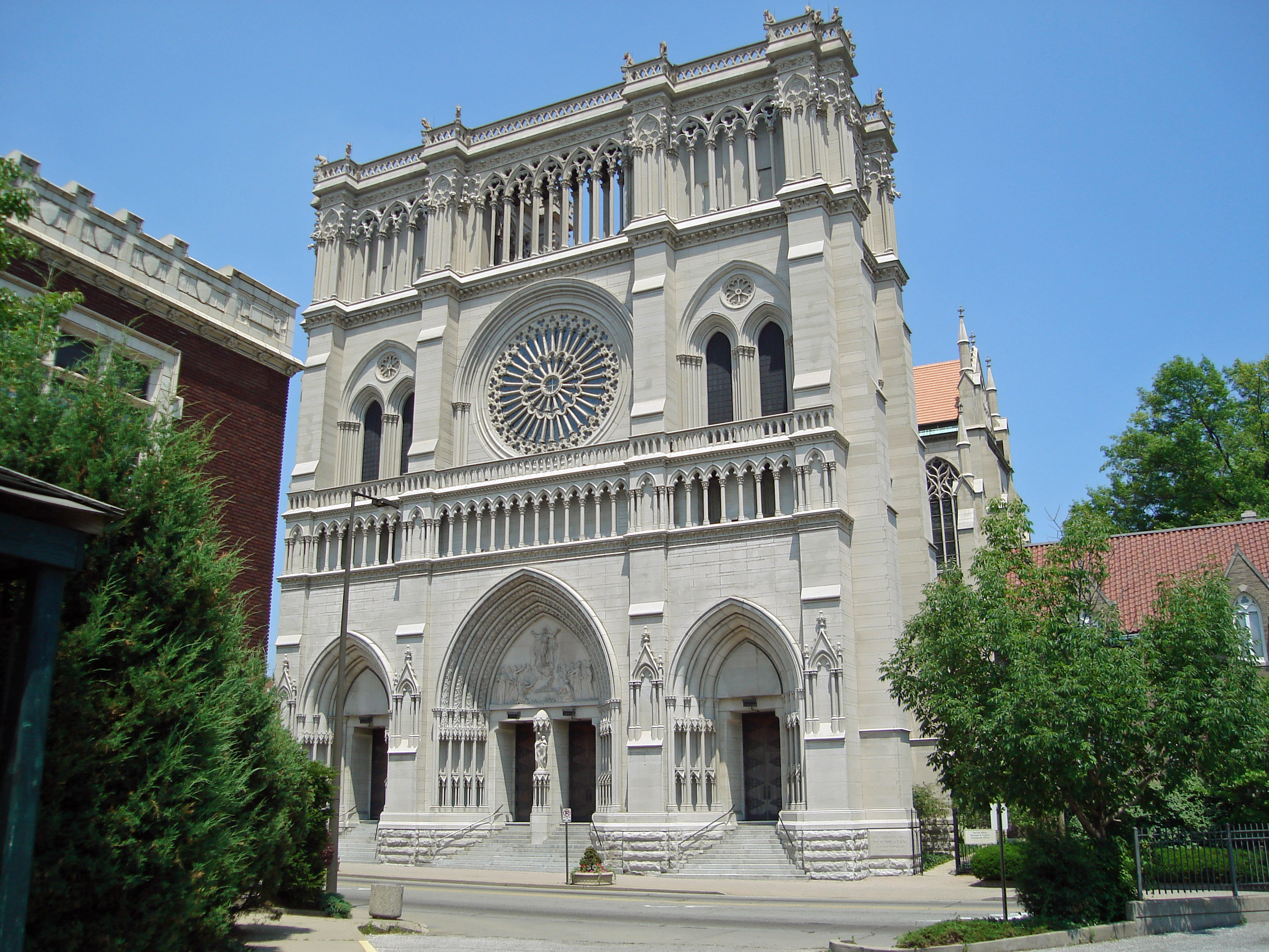
39°02′48″N 84°33′19″W / 39.046667°N 84.555278°WFort Mitchell 5 Cathedral Basilica of the Assumption 
July 20, 1973 1130 Madison Ave.
39°04′42″N 84°30′29″W / 39.078333°N 84.508056°WCovington 6 Central Ludlow Historic District November 28, 1984 Roughly bounded by Glenwood, Church, Adela, and Carneal Sts.
39°05′34″N 84°33′00″W / 39.092778°N 84.55°WLudlow 7 Covington and Cincinnati Suspension Bridge 
May 15, 1975 Spans the Ohio River between Covington and Cincinnati, Ohio
39°05′32″N 84°30′34″W / 39.092222°N 84.509444°WCovington Extends into Cincinnati, Ohio 8 Covington Downtown Commercial Historic District June 9, 1983 Roughly bounded by the Chesapeake & Ohio railroad line, Robbins, Greenup, and 4th Sts.; also 9th, Washington, and 7th Sts. and Madison Ave.; also 701, 702, 709, 711, 713, 715, 722 and 723-725 Scott Boulevard; also approximately located along Scott, Pine, and E. 8th Sts.
39°05′01″N 84°30′38″W / 39.083611°N 84.510556°WCovington Lists of streets beginning with "also" represent separate boundary increases 9 Dixie Highway Historic District February 19, 1988 2696, 2698, 2700, 2708, and 2712 Dixie Hwy.
39°01′55″N 84°34′20″W / 39.031944°N 84.572222°WLakeside Park 10 Eleventh District School June 16, 1983 Parkway and Altamont St.
39°05′24″N 84°32′09″W / 39.09°N 84.535833°WCovington 11 Elmwood Hall 
August 7, 1972 244-246 Forrest Ave.
39°05′42″N 84°32′56″W / 39.095°N 84.548889°WLudlow 12 Emery Row 
November 14, 1985 810-828 Scott Blvd.
38°59′30″N 84°30′42″W / 38.991667°N 84.511667°WCovington 13 Emery-Price Historic District 
February 18, 1987 Roughly bounded by 8th, Greenup, and 11th Sts., and the alley behind the western side of Scott Blvd.
39°04′53″N 84°30′24″W / 39.081389°N 84.506667°WCovington 14 Erlanger Proper Subdivision Historic District September 6, 2002 Roughly bounded by Hulbert, Division, Crescent, Dixie, and Graves.
39°01′12″N 84°36′02″W / 39.02°N 84.600556°WErlanger 15 Fifth District School 
November 25, 2005 1735 Homan Ave.
39°04′06″N 84°30′44″W / 39.068333°N 84.512222°WCovington 16 Fort Mitchell Heights Historic District September 8, 1989 Roughly bounded by Park Rd., Barrington Rd., Dixie Highway, and Fortside Dr.
39°03′33″N 84°32′39″W / 39.059167°N 84.544167°WFort Mitchell 17 Fourth District Elementary School 
February 3, 2010 1508-1510 Scott St.
39°04′26″N 84°30′21″W / 39.073767°N 84.505872°WCovington 18 GAR Monument in Covington 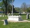
July 17, 1997 1413 Holman St.
39°04′23″N 84°30′53″W / 39.073056°N 84.514722°WCovington 19 Hearne House 
June 24, 1974 500 Garrard St.
39°05′11″N 84°30′21″W / 39.086389°N 84.505833°WCovington 20 Helentown Historic District February 18, 1987 Roughly bounded by 11th and Wheeler Sts., the Chesapeake & Ohio railroad line, and Madison Blvd.
39°04′34″N 84°30′16″W / 39.076111°N 84.504444°WCovington 21 Highland Cemetery Historic District October 12, 1989 2167 Dixie Highway
39°02′31″N 84°32′48″W / 39.041944°N 84.546667°WFort Mitchell 22 Holy Cross Church and School Complex-Latonia 
April 17, 1986 3600 block of Church St.
39°02′52″N 84°30′08″W / 39.047778°N 84.502222°WCovington 23 House at 855-857 Oak Street November 28, 1984 855-857 Oak Street
39°05′09″N 84°33′25″W / 39.085833°N 84.556944°WLudlow 24 House at 859 Oak Street November 28, 1984 859 Oak St.
39°05′07″N 84°33′28″W / 39.085278°N 84.557778°WLudlow 25 May 20, 1982 Greenup St.
39°05′29″N 84°30′30″W / 39.091389°N 84.508333°WCovington 26 Kenney's Crossing March 22, 1990 1001 Highway Ave.
39°05′23″N 84°31′45″W / 39.089722°N 84.529167°WCovington 27 Kenton County Library 
October 31, 1972 1028 Scott St.
39°04′48″N 84°30′26″W / 39.08°N 84.507222°WCovington 28 Kruempelman Farmhouse September 8, 1989 24 Ridge Rd.
39°03′22″N 84°32′55″W / 39.056111°N 84.548611°WFort Mitchell 29 Lee-Holman Historic District July 25, 1996 Bounded by W. Robbins, Holman, W. 12th, and Lee Sts.
39°04′40″N 84°30′52″W / 39.077778°N 84.514444°WCovington 30 Lewisburg Historic District November 5, 1993 Roughly bounded by Interstate 75 and the Covington city limits
39°04′37″N 84°31′23″W / 39.076944°N 84.523056°WCovington 31 Licking Riverside Historic District 
July 30, 1975 Roughly bounded by 4th, Scott, 8th Sts., and the Licking River
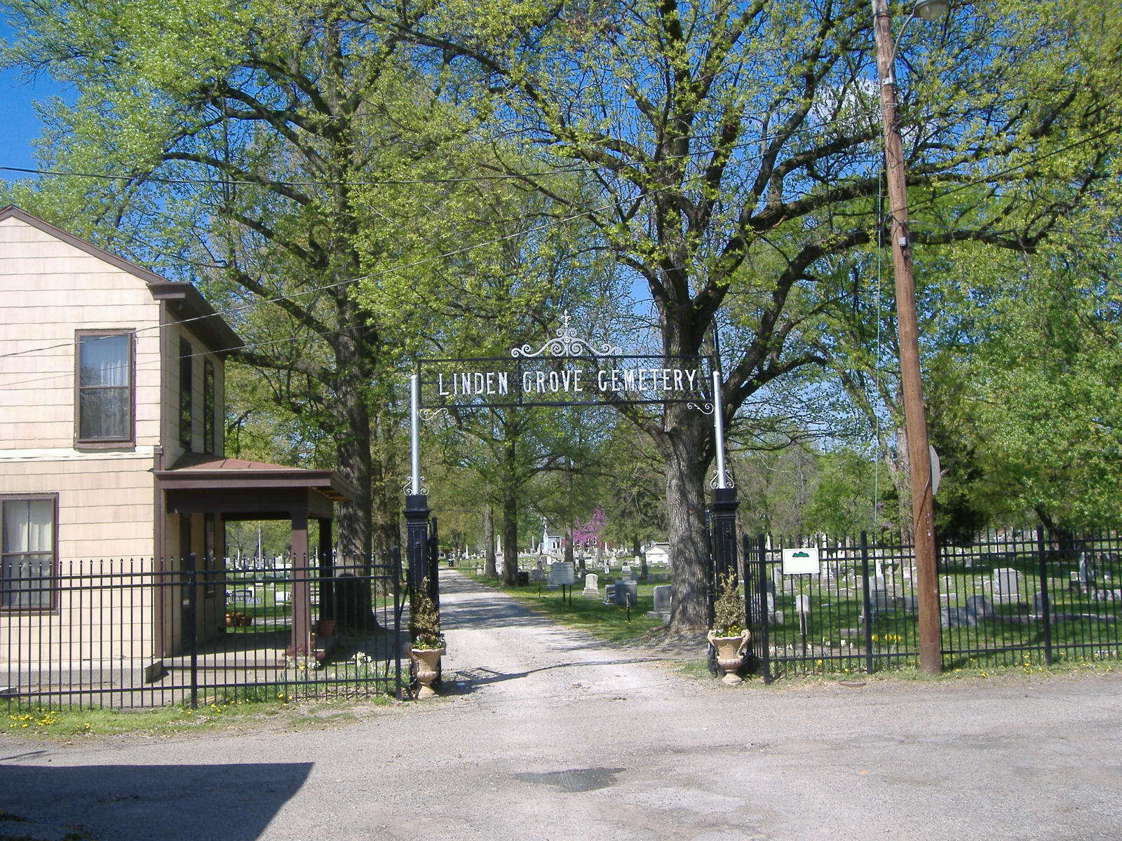
39°05′05″N 84°30′22″W / 39.084722°N 84.506111°WCovington 32 Linden Grove Cemetery 
January 4, 2001 1421 Holman Ave.
39°04′25″N 84°30′53″W / 39.073611°N 84.514722°WCovington 33 Ludlow Lagoon Clubhouse November 28, 1984 312 Lake St.
39°05′04″N 84°33′15″W / 39.084444°N 84.554167°WLudlow 34 Maxwell House November 28, 1984 27 River Rd.
39°05′44″N 84°32′29″W / 39.095556°N 84.541389°WLudlow 35 Prettyman Merry House January 8, 1987 Shelby St.
39°04′56″N 84°33′49″W / 39.082222°N 84.563611°WBromley 36 Metcalfe-Stephens House November 12, 1998 5241 Madison Pike
38°56′42″N 84°32′36″W / 38.945°N 84.543333°WIndependence 37 Moser Family Houses August 2, 2000 1224 and 1226 Highway Ave.
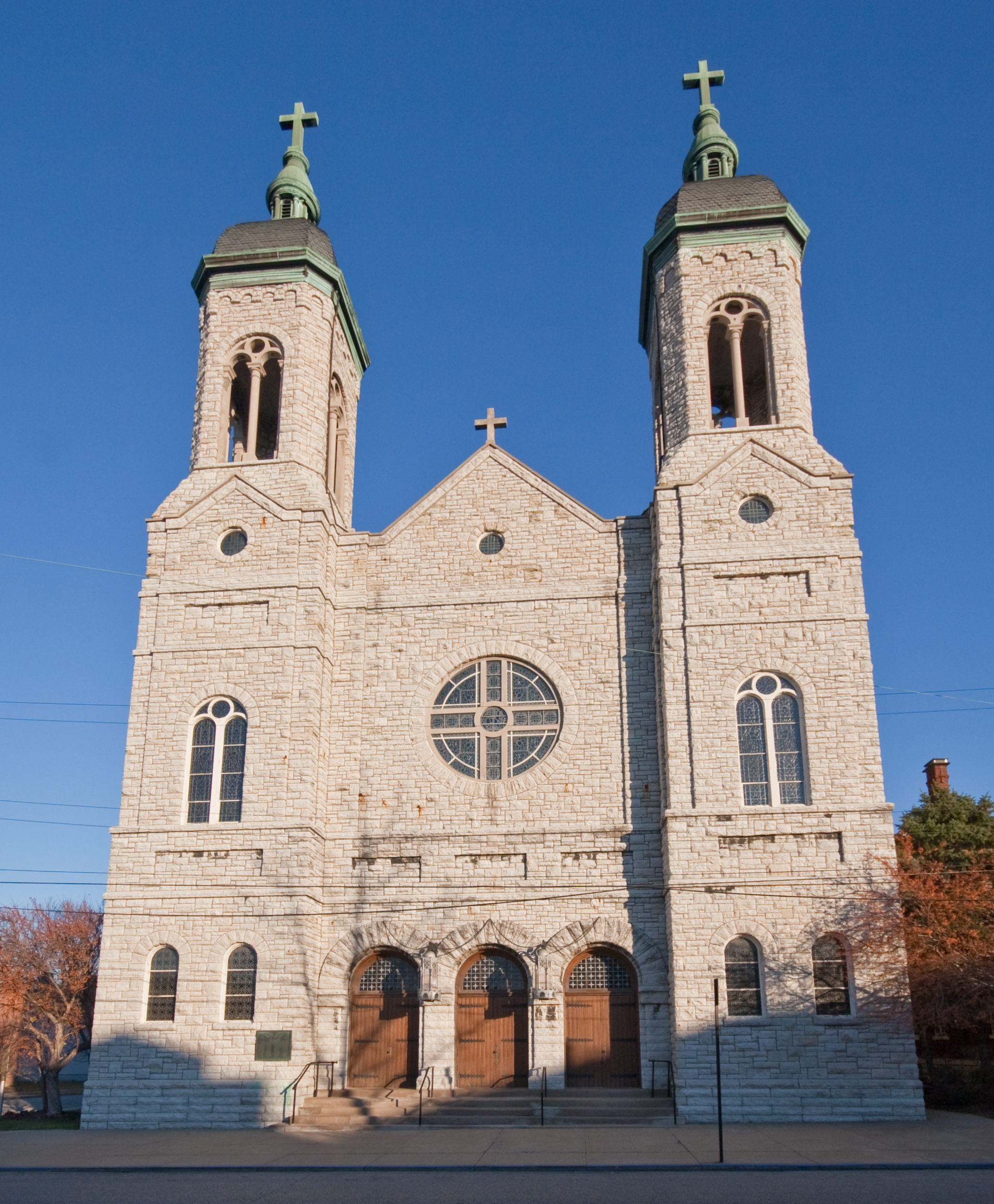
39°05′23″N 84°31′58″W / 39.089722°N 84.532778°WCovington 38 Mother of God Roman Catholic Church 
July 24, 1973 119 W. 6th St.
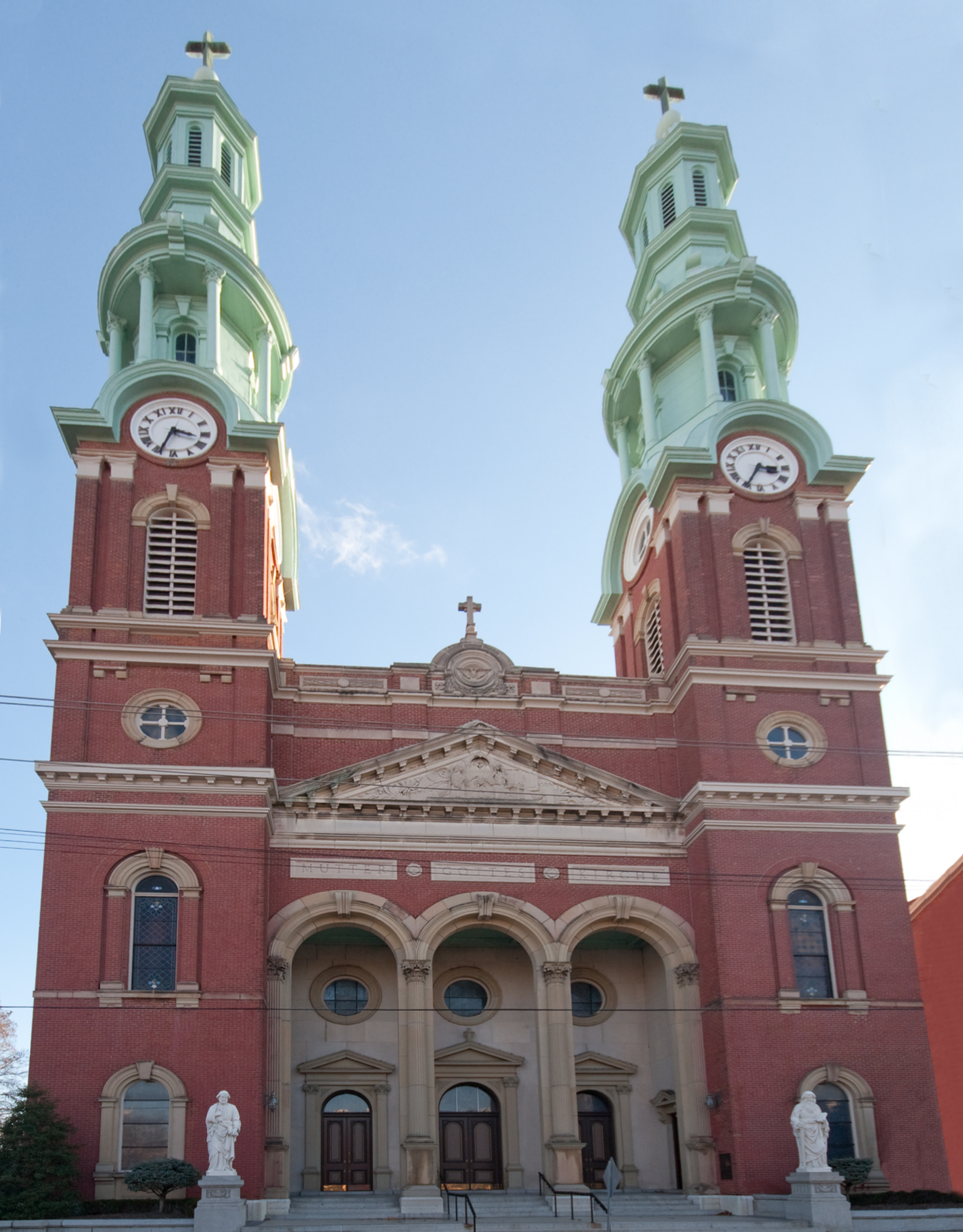
39°05′02″N 84°30′45″W / 39.083889°N 84.5125°WCovington 39 Mutter Gottes Historic District 
May 29, 1980 Roughly bounded by Madison Ave., 4th, Harvey, and Johnson Sts.; also roughly bounded by Madison Ave. and 4th, Harvey, and Johnson Sts.
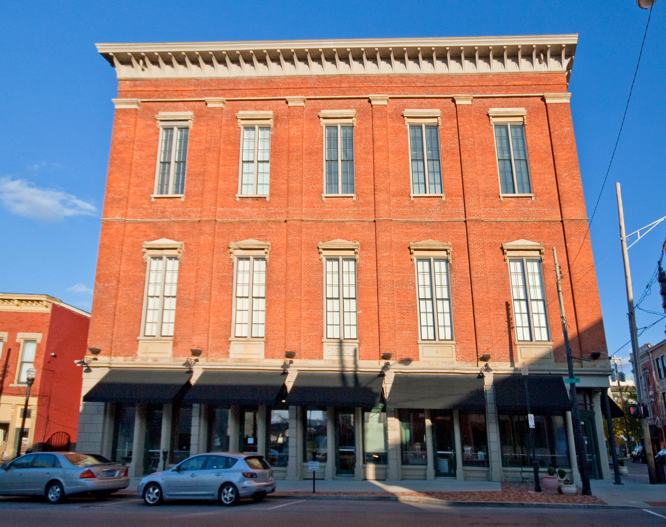
39°05′06″N 84°30′49″W / 39.085°N 84.513611°WCovington Second list of streets represents a boundary increase 40 Northern Bank of Kentucky 
December 23, 1998 241-45 Scott Blvd.
39°05′18″N 84°30′36″W / 39.088333°N 84.51°WCovington 41 Odd Fellows Hall 
August 11, 1980 5th and Madison Sts.
39°05′09″N 84°30′38″W / 39.085833°N 84.510556°WCovington 42 Old Fort Mitchell Historic District September 8, 1989 Roughly bounded by Saint Johns Rd., Dixie Highway, E. Maple Ave., and Edgewood Rd.
39°03′19″N 84°33′07″W / 39.055278°N 84.551944°WFort Mitchell 43 Park Hills Historic District 
March 13, 2008 Roughly bounded by Dixie Highway, Montague, Breckenridge, Sleepy Hollow Rds., Old State, Arlington Rds., and St. James Ave.
39°04′17″N 84°31′56″W / 39.07145°N 84.532164°WPark Hills 44 Robert Patton House 
March 1, 1984 1533 Garrand St.
39°03′51″N 84°30′10″W / 39.064167°N 84.502778°WCovington 45 Pleasant Run Stone House I January 8, 1987 Bromley Rd. off KY 8
39°04′31″N 84°33′29″W / 39.075278°N 84.558056°WBromley 46 Pleasant Run Stone House II January 8, 1987 Bromley Rd. off KY 8
39°04′19″N 84°33′36″W / 39.071944°N 84.56°WBromley 47 Ritte's Corner Historic District, Latonia 
May 21, 1987 Roughly bounded by DeCoursey, Southern, Inez, and Winston Aves.; also approximately 3424-3601 Decoursey Ave., 9 E. Southern Ave., and CSX railroad property
39°02′50″N 84°30′12″W / 39.047222°N 84.503333°WCovington Second group of streets represents a boundary increase 48 Riverside Drive Historic District 
November 23, 1971 Bounded by Riverside Dr., 4th St., the Licking River, and the alley between Greenup and Garrard Sts.; also along sections of Greenup St., Court Ave., 3rd, and 4th Sts.
39°05′23″N 84°30′23″W / 39.089722°N 84.506389°WCovington Second list of streets represents a boundary increase 49 St. Augustine Church Complex 
November 25, 2005 1839 Euclid Ave.
39°03′58″N 84°30′47″W / 39.066111°N 84.513056°WCovington 50 Seminary Square Historic District May 27, 1980 Roughly bounded by railroad tracks and Holman, 9th, and 12th Sts.
39°04′45″N 84°30′45″W / 39.079167°N 84.512589°WCovington 51 Amos Shinkle Summer Residence April 28, 1983 U.S. Route 25
39°01′48″N 84°34′33″W / 39.03°N 84.575833°WFort Mitchell 52 Trinity Episcopal Church 
March 1, 1982 326 Madison Ave.
39°05′15″N 84°30′39″W / 39.0875°N 84.510833°WCovington 53 Veteran's Monument in Covington 
July 17, 1997 1413 Holman St.
39°04′22″N 84°30′54″W / 39.072778°N 84.515°WCovington 54 Wadsworth Electric Manufacturing Company 
January 28, 1994 20 W. 11th St.
39°04′45″N 84°30′36″W / 39.079167°N 84.51°WCovington 55 Wallace Woods Area Residential Historic District 
August 11, 1983 Roughly bounded by 24th St. and Glenway, Wallace, and Madison Aves.
39°03′54″N 84°30′02″W / 39.065°N 84.500556°WCovington 56 West Fifteenth Street Historic District 
February 18, 1987 1445-1451 and 1501-1513 Madison Ave., 1421-1423 Neave St., and 10-32 W. Fifteenth St.
39°04′27″N 84°30′30″W / 39.074167°N 84.508333°WCovington 57 West Side-Main Strasse Historic District 
November 10, 1983 Roughly bounded by the Chesapeake & Ohio railroad line and 6th, Philadelphia, Dalton, Pike, and Robbins Sts.
39°04′52″N 84°31′00″W / 39.081111°N 84.516667°WCovington 58 William A. Yeager and Edward Mohr Farmstead November 25, 1994 5002 Madison Pike
38°57′34″N 84°32′22″W / 38.959444°N 84.539444°WIndependence See also
- List of National Historic Landmarks in Kentucky
- National Register of Historic Places listings in Kentucky
References
- ^ The latitude and longitude information provided in this table was derived originally from the National Register Information System, which has been found to be fairly accurate for about 99% of listings. For about 1% of NRIS original coordinates, experience has shown that one or both coordinates are typos or otherwise extremely far off; some corrections may have been made. A more subtle problem causes many locations to be off by up to 150 yards, depending on location in the country: most NRIS coordinates were derived from tracing out latitude and longitudes off of USGS topographical quadrant maps created under North American Datum of 1927, which differs from the current, highly accurate GPS system used by Google maps. Chicago is about right, but NRIS longitudes in Washington are higher by about 4.5 seconds, and are lower by about 2.0 seconds in Maine. Latitudes differ by about 1.0 second in Florida. Some locations in this table may have been corrected to current GPS standards.
- ^ "National Register of Historic Places: Weekly List Actions". National Park Service, United States Department of the Interior. Retrieved on November 10, 2011.
- ^ Numbers represent an ordering by significant words. Various colorings, defined here, differentiate National Historic Landmark sites and National Register of Historic Places Districts from other NRHP buildings, structures, sites or objects.
U.S. National Register of Historic Places Topics Lists by states Alabama • Alaska • Arizona • Arkansas • California • Colorado • Connecticut • Delaware • Florida • Georgia • Hawaii • Idaho • Illinois • Indiana • Iowa • Kansas • Kentucky • Louisiana • Maine • Maryland • Massachusetts • Michigan • Minnesota • Mississippi • Missouri • Montana • Nebraska • Nevada • New Hampshire • New Jersey • New Mexico • New York • North Carolina • North Dakota • Ohio • Oklahoma • Oregon • Pennsylvania • Rhode Island • South Carolina • South Dakota • Tennessee • Texas • Utah • Vermont • Virginia • Washington • West Virginia • Wisconsin • WyomingLists by territories Lists by associated states Other Municipalities and communities of Kenton County, Kentucky Cities Bromley | Covington | Crescent Springs | Crestview Hills | Edgewood | Elsmere | Erlanger | Fairview | Fort Mitchell | Fort Wright | Independence | Kenton Vale | Lakeside Park | Ludlow | Park Hills | Ryland Heights | Taylor Mill | Villa Hills | Walton

Unincorporated
communitiesAtwood | Latonia Lakes | Nicholson | Visalia
Categories:- National Register of Historic Places in Kentucky by county
- Kenton County, Kentucky
-


Wikimedia Foundation. 2010.