- Na Mom District
-
Na Mom
นาหม่อม— Amphoe — Amphoe location in Songkhla Province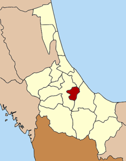
Coordinates: 6°57′30″N 100°33′25″E / 6.95833°N 100.55694°ECoordinates: 6°57′30″N 100°33′25″E / 6.95833°N 100.55694°E Country  Thailand
Province Songkhla Seat Na Mom Tambon Muban Amphoe established Area – Total 92.47 km2 (35.7 sq mi) Population (2005) – Total 20,950 – Density 226.6/km2 (586.9/sq mi) Time zone THA (UTC+7) Postal code 90310 Geocode 9012 Na Mom (Thai: นาหม่อม) is a district (Amphoe) of Songkhla Province, southern Thailand.
Contents
History
The district was at first the tambon Thung Phra Khian (ทุ่งพระเคียน) of Hat Yai district, which was changed into tambon Na Mom in 1943. On April 30 1981 it was made the minor district (King Amphoe) Na Mom, together with three further tambon from Hat Yai district.[1] It was upgraded to a full district on July 4 1994.[2]
Geography
Neighboring districts are (from the north clockwise) Mueang Songkhla, Chana and Hat Yai.
Administration
The district is subdivided into 4 subdistricts (tambon), which are further subdivided into 29 villages (muban). There are no municipal (thesaban) areas within the district, and further 4 Tambon administrative organizations (TAO).
No. Name Thai name Villages Inh. 1. Na Mom นาหม่อม 10 7,537 2. Phichit พิจิตร 6 4,343 3. Thung Khamin ทุ่งขมิ้น 7 4,986 4. Khlong Rang คลองหรัง 6 4,084 References
- ^ "ประกาศกระทรวงมหาดไทย เรื่อง แบ่งท้องที่อำเภอหาดใหญ่ จังหวัดสงขลา ตั้งเป็นกิ่งอำเภอนาหม่อม" (in Thai). Royal Gazette 98 (84 ง): 1645. June 2 1981. http://www.ratchakitcha.soc.go.th/DATA/PDF/2524/D/084/1654.PDF.
- ^ "พระราชกฤษฎีกาตั้งอำเภอเปือยน้อย ... และอำเภอศรีวิไล พ.ศ. ๒๕๓๗" (in Thai). Royal Gazette 111 (21 ก): 32–35. June 3 1994. http://www.ratchakitcha.soc.go.th/DATA/PDF/2537/A/021/32.PDF.
External links
Mueang Songkhla - Sathing Phra - Chana - Na Thawi - Thepha - Saba Yoi - Ranot - Krasae Sin - Rattaphum - Sadao - Hat Yai - Na Mom - Khuan Niang - Bang Klam - Singhanakhon - Khlong Hoi Khong
Categories:- Amphoe of Songkhla
- Southern Thailand geography stubs

Wikimedia Foundation. 2010.