- Mueang Sukhothai District
-
Mueang Sukhothai
เมืองสุโขทัย— Amphoe — Amphoe location in Sukhothai Province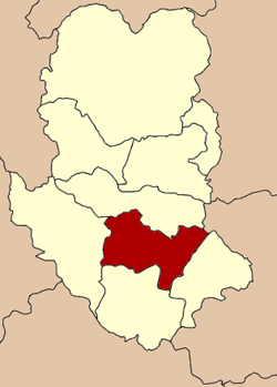
Coordinates: 17°0′28″N 99°49′23″E / 17.00778°N 99.82306°ECoordinates: 17°0′28″N 99°49′23″E / 17.00778°N 99.82306°E Country  Thailand
Province Sukhothai Seat Thani Area – Total 581.5 km2 (224.5 sq mi) Population (2008) – Total 106,397 – Density 185.0/km2 (479.1/sq mi) Time zone THA (UTC+7) Postal code 64000 Geocode 6401 Mueang Sukhothai (Thai: เมืองสุโขทัย) is the capital district (Amphoe Mueang) of Sukhothai Province, northern Thailand.
Contents
Geography
Neighboring districts are (from the southeast clockwise) Kong Krailat, Khiri Mat, Ban Dan Lan Hoi and Si Samrong of Sukhothai Province and Phrom Phiram of Phitsanulok Province.
The important water resource is the Yom River.
History
Originally named Mueang as the capital district of Sukhothai province, in 1917 the district was renamed to Thani (ธานี).[1] In 1932, the province Sukhothai was abolished and merged into Sawankhalok province.[2] 1939 the province was renamed to Sukhothai, and the district, by then named Sukhothai Thani (สุโขทัยธานี) was renamed to Mueang Sukhothai.[3]
Administration
The district is subdivided into 10 subdistricts (tambon), which are further subdivided into 98 villages (muban). The town (thesaban mueang) Sukhothai covers the whole tambon Thani. there are further two subdistrict municipalities (thesaban tambon) - Ban Suan and Mueang Kao, each covering parts of the same-named tambon. There are further 9 Tambon administrative organizations (TAO).
No. Name Thai Villages Inh.[4] 1. Thani ธานี - 16,479 2. Ban Suan บ้านสวน 14 14,249 3. Mueang Kao เมืองเก่า 11 17,482 4. Pak Khwae ปากแคว 9 9,195 5. Yang Sai ยางซ้าย 12 9,749 6. Ban Kluai บ้านกล้วย 14 17,270 7. Ban Lum บ้านหลุม 9 8,988 8. Tan Tia ตาลเตี้ย 11 4,245 9. Pak Phra ปากพระ 10 3,695 10. Wang Thong Daeng วังทองแดง 8 5,045 References
- ^ "ประกาศกระทรวงมหาดไทย เรื่อง เปลี่ยนชื่ออำเภอ" (in Thai). Royal Gazette 34 (0 ก): 40–68. 1917-04-29. http://www.ratchakitcha.soc.go.th/DATA/PDF/2460/A/40.PDF.
- ^ "พระบรมราชโองการ ประกาศ ยุบรวมท้องที่บางมณฑลและบางจังหวัด" (in Thai). Royal Gazette 48 (0 ก): 576–578. 1932-02-21. http://www.ratchakitcha.soc.go.th/DATA/PDF/2474/A/576.PDFF.
- ^ "พระราชกฤษฎีกาเปลี่ยนนามจังหวัดและอำเภอบางแห่ง พุทธศักราช ๒๔๘๒" (in Thai). Royal Gazette 56 (0 ก): 351–353. 1939-04-17. http://www.ratchakitcha.soc.go.th/DATA/PDF/2482/A/351.PDF.
- ^ "Population statistics 2008". Department of Provincial Administration. http://www.dopa.go.th/xstat/p5164_01.html.
External links
- amphoe.com (Thai)
Categories:- Amphoe of Sukhothai
- Northern Thailand geography stubs

Wikimedia Foundation. 2010.