- Maramureș
-
For other uses, see Maramureş (disambiguation).
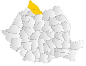 Map of Romania with Maramureş region highlighted
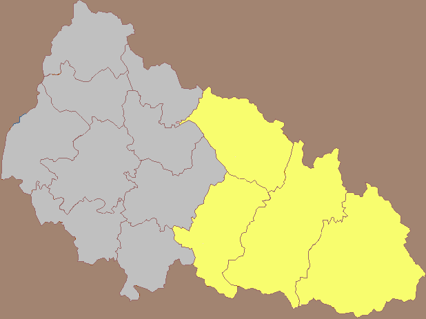
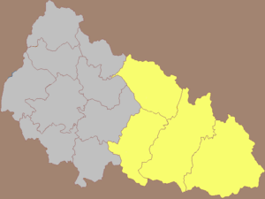 Northern Maramureş as part of the Zakarpattia Oblast of Ukraine
Maramureș (Romanian: Maramureș; Ukrainian: Мармарощина / Marmaroshchyna, Мараморщина / Maramorshchyna; Rusyn: Мараморош / Maramorosh; Hungarian: Máramaros; German: Maramuresch; Latin: Marmatia) is a geographical, historical and ethno-cultural region in northern Romania and western Ukraine. It is situated on the northeastern Carpathians, along the upper Tisa River; it covers the Maramureș Depression and the surrounding Carpathian mountains.
Alternatively, the name Maramureș is used for the Maramureș County of Romania, which contains the southern section of the historical region.
Contents
Geography
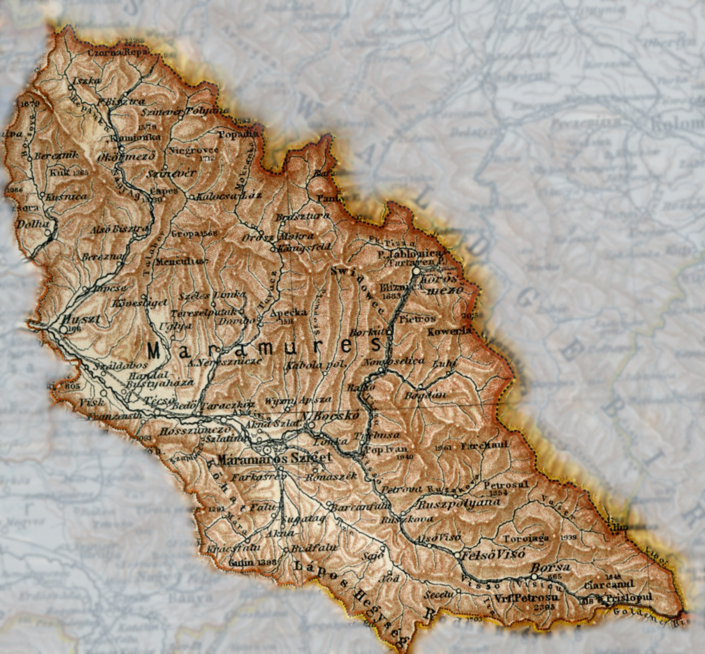
Maramureș is a valley totally enclosed by mountains Oaș, Gutâi, Țibleș and Rodnei to the west and south, Maramureș Mountains and Ukrainian Carpathians (Wooded Carpathians) to the east and north, with a thin opening at Khust. Several dozen small mountain rivers and creeks flow into the river Tisa. It is forested and not easily accessible.
The limits of the region are between the parallels of 47o33' N and 40o02' N and the meridians of 23o15' E and 25o03' E. Maramureş represents one of the largest depressions in the Carpathians, covering an area of about 10000 km².
Its length from Khust to Prislop Pass is about 150 km and width from North to South is up to 80 km.
The main mountain passes linking Maramureş with the neighboring regions are high and in the past were hardly accessible in the winter. Prislop Pass (1414m high) links the region in the east towards Moldavia, Dealul Ştefăniţei (1254m) in the south towards Transylvania, Pintea Pass (987m) towards Baia Mare and Fărgău (587m) in the west towards Oaş Country, while Frasini Pass (Yasinia) (931m) links the region in the north to Galicia.
The mountains surrounding this region occupy more than half of the area. Several peaks reach 2000m, such as Pietrosul (2303m) in the Rodnei Mountains to the south and Hovîrla (2061m) in Muntele Negru (Cernahora) to the north.
The heavy forested mountains sustain many protected species of plants, such as yew (Taxus baccata), larch (Larix decidua), Swiss pine (Pinus cembra), edelweiss (Leontopodium alpinum); and animals, such as lynx (Lynx lynx), chamois (Rupicapra rupicapra), alpine marmot (Marmota marmota), golden eagle (Aquila chrysaetos), and capercaillie (Tetrao urogallus).
The last Romanian wisent, hunted to extinction in Romania in 1852, lived here. Lostriţa, a local variety of salmon, still live in the mountain rivers.
Several protected areas have been created in the Maramureş. Rodnei Mountains National Park was designated in 1930, Maramureş Mountains Natural Park in 2004 and there are many other caves, gorges, cliff formations and lakes that are officially protected areas.
History
 Maramuresch county on the map of the Habsburg Kingdom of Hungary, 1780-84. The present-day borders of Romania are projected to the historical map.
 Máramaros County (Hungarian: Máramaros vármegye; Romanian: Comitatul Maramureş; Ukrainian: Комітат Марамарош), 1905Main article: History of Maramureş
In ancient times, this area was settled by Celts, Dacians, Sarmatians and Germanic peoples. In the first century BC, it was part of the Dacian Kingdom under Burebista, while in the early middle ages, it was ruled by the Hunnic Empire, the Kingdom of the Gepids, the Kingdom of the Avars, the White Croatia, the Kievan Rus', and the Bulgarian Empire.
The territory was under loose control of the medieval Kingdom of Hungary from the 11th century and was nominally divided between the Gyepű border region, comitatus of Szatmár and comitatus of Borsova. Later, the whole region was included into the comitatus of Máramaros. Initially, the inhabitants of the region were allowed to preserve their native political organization, the Voevodates, which formed many small autonomous areas. The King long struggled[citation needed] to convince the Voivodes to accept the title of Count, with the implied dependency in political and financial matters, which to the locals meant losing their independence – a thing they could not bear. During the Middle Ages, the people in many mountain villages, where each family by definition had a considerable domain, were called nameşi, meaning free peasants taking pride in their family (the term points to their belonging to a small clan, from Romanian neam = extended family). Another possible explanation to the term "nameşi" is that in the Kingdom of Hungary, free people possessing land were called "nemes" in Hungarian.
In the 16th century, medieval Kingdom of Hungary was invaded and destroyed by the Ottoman Empire, and area came under administration of the semi-independent Ottoman Principality of Transylvania and later (in the end of the 17th century) under administration of the Habsburg Monarchy (later known as the Austrian Empire). During Habsburg administration, region was firstly part of the Habsburg Principality of Transylvania, but was later (in 1732) included into the Habsburg Kingdom of Hungary. In 1867, the Austrian Empire was transformed into the dual monarchy of Austria-Hungary and the region was included into the Transleithania or Hungarian part of the Monarchy and formed the Máramaros County.
After the First World War, the region was divided between Romania and Czechoslovakia, while during World War II (from 1939/1940 to 1944), the whole area was controlled by Hungary. After WWII, the southern section remained within the Romanian borders and is now part of Maramureș County; the northern section was incorporated into the Soviet Union and is now part of Zakarpattia Oblast of independent Ukraine.
People
In the southern area, the majority of the population are Romanians. There are also some Hungarians, Rusyns (Ukrainians), Zipser Germans and Roma. In the northern area, the majority are Ukrainians, with smaller Romanian, Hungarian and German communities.
In the northern area most people speak Ukrainian language, while in the southern area most speak Romanian, which is why the region was split into two parts. Since 1940s there have been villages cut in two by the state border. There are some villages in the north (within Ukraine) that have sizable Romanian population, as well as some villages in Romania that have sizable Ukrainian population.
Culture and traditions
References
- Atlas and Gazetteer of Historic Hungary 1914, Talma Kiadó ISBN 9638568348
- Museum of Tolerance
- Sighetul Marmatiei, Culture and Tourism 2007, Teofil Ivanciuc ISBN 973-7663-12-8
External links
 Historical regions in RomaniaBanat (1918–)a • Dobruja (Northern Dobruja (1878–) • Southern Dobruja (1913–40) • Moldavia (1866–) (Bessarabia (1918–40; 1941–44)b • Bukovinac • Hertza (1866–1940; 1941–44)) • Transylvania (1918–)ad (Crişanae • Maramureş) • Wallachia (1866-) (Muntenia • Oltenia)
aDe jure since 1920. bCahul, Ismail and Bolgrad in Romania, 1866–78.
cSouthern Bukovina in Romania 1918–; Northern Bukovina, 1918–40. dNorthern Transylvania in Hungary, 1940–44. eOnly the eastern part.Ukrainian historical regions Kievan Rus' Principalities Medieval epoch Red Ruthenia · Galicia–Volhynia · Bełz Voivodeship · Bracław Voivodeship · Czernihów Voivodeship · Kijów Voivodeship · Podole Voivodeship · Ruthenian VoivodeshipCossack epoch Cossack Hetmanate · Right-bank Ukraine · Left-bank Ukraine · Sloboda Ukraine · Zaporozhian Sich · Dnieper Ukraine · Little RussiaRussian Imperial guberniyas Austro-Hungarian provinces 20th century Ukrainian SSR · Moldavian ASSR · Drohobych Oblast · Izmail Oblast · Crimean Oblast · Lviv Voivodeship · Ternopil Voivodeship · Volhynian Voivodeship · Stanyslaviv Voivodeship · Carpatho-Ukraine · Reichskommissariat Ukraine · Distrikt GalizienGeographical Nadbuzhia · Budzhak · Black Sea Ukraine · Donbas · Dniester Ukraine · Podolia · Pokuttya · Pryazovya · New Russia · Polissya · Podniprovya · Porossia · Prydunavya · Prykarpattia · Porizhia Ukraine · Volhynia · ArtaniyaEthno-Ukrainian regions abroad Categories:


Wikimedia Foundation. 2010.