- Ruthenian Voivodeship
Infobox Former Subdivision
native_name = Palatinatus Russiae
conventional_long_name = Ruthenian Voivodeship
common_name = Ruthenia
subdivision = Voivodeship
nation = Poland¹

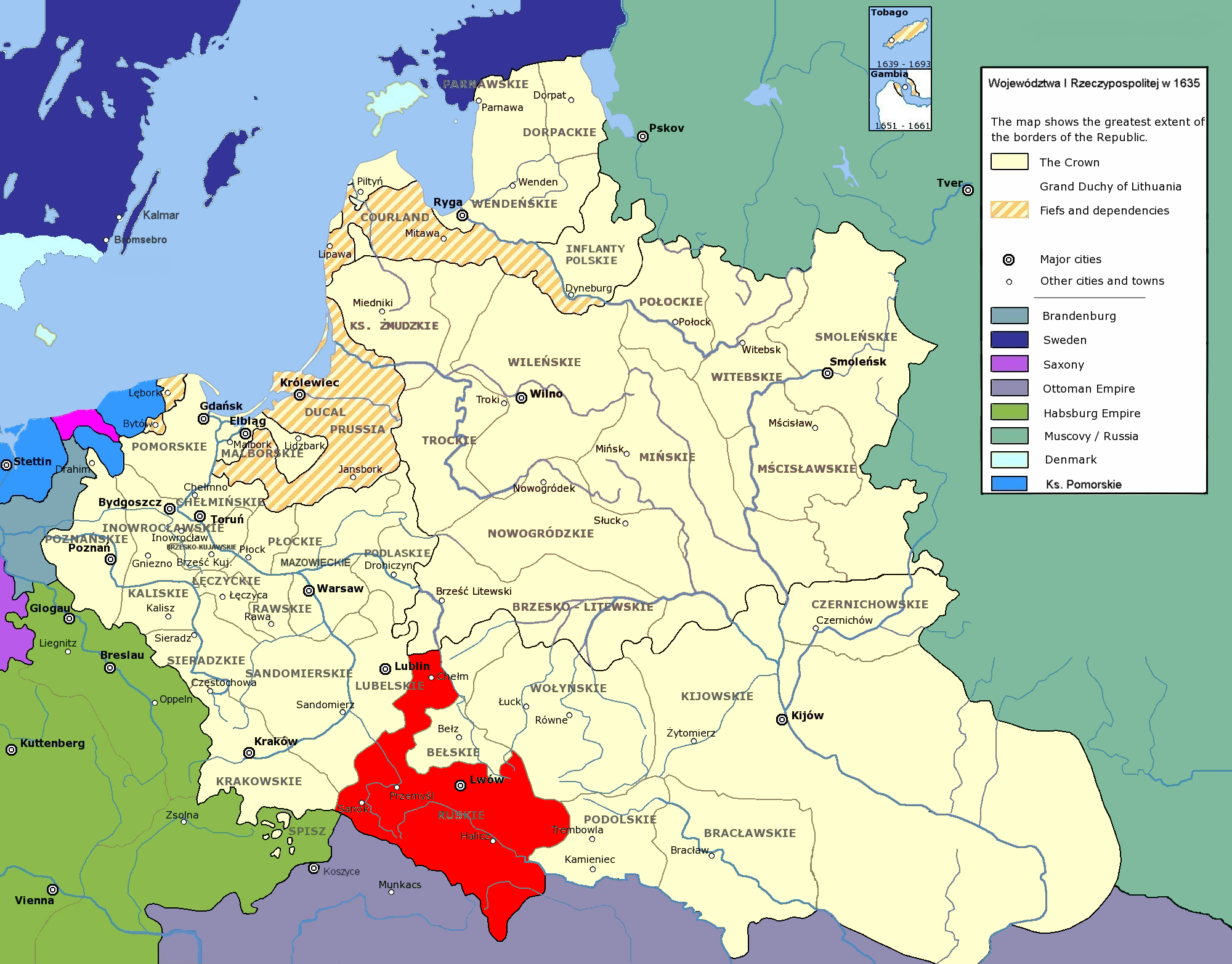
image_map_caption = The Ruthenian Voivodeship in
thePolish-Lithuanian Commonwealth in 1635.
capital = Lviv
stat_area1 = 55200
stat_year1 = 1770
stat_pop1 = 1495000
p1= Halych-Volhynia
image_p1 =
s1 = Kingdom of Galicia and Lodomeria
image_s1 =
year_start = 1366
year_end = 1772
political_subdiv = Urban counties: 13
Land counties: 5Gmina : 200
footnotes = ¹ Voivodeship of the Kingdom of Poland. The kingdom was part of thePolish-Lithuanian Commonwealth from 1569.Ruthenia Voivodeship ( _la. Palatinatus russiae, _pl. województwo ruskie; 1366–1772) [ [http://univ.gda.pl/~literat/glogre/0037.htm Geografia historyczna ziem dawnej Polski.] by
Zygmunt Gloger 1903. [in] Biblioteka Literatury Polskiej.Uniwersytet Gdański . Instytut Filologii Polskiej. 2003] was an administrative division of the Kingdom of Poland (see [Kingdom of Poland (1320–1385)|Kingdom of Poland [1320–1385] , [Kingdom of Poland (1385–1569)|Kingdom of Poland [1385–1569] , and Polish-Lithuanian Commonwealth, 1569–1791). Together withBełz Voivodeship , it formed Lesser Poland Province with its capitol city inKraków . Part ofLesser Poland region. This region was later largely part of the Austrian province of Galicia and today is divided amongPoland ,Ukraine andBelarus .History
Settled in prehistoric times, the central-eastern European land that is now (sountern-eastern part in Poland, western in Ukraine) was overrun in pre-Roman times by various tribes, including the
Celts ,Goths andVandals (Przeworsk culture ). After the fall of the Roman Empire, of which most of eastern Poland was part (all parts below the San and Dniester), the area was invaded by Hungarians, Slavs and Avars. starting in at least the 9th century.
220px|thumb|Map of Great Moravia at its possible greatest territorial extent during the reign of Svatopluk I (871-894), superimposed on the modern borders of European states."Note that some of the borders of Great Moravia are under debate."Originally it was related to a certain territory betweenWestern Bug andWieprz rivers. Its Polish name was "Ziemia czerwieńska", or "Czerwień Land" by the name of Cherven, a town that existed there. (Today there are several towns with this name, none of them related to Red Ruthenia) [ [http://dir.icm.edu.pl/pl/Slownik_geograficzny/Tom_XV_cz.2/561 Geographical Dictionary of the Kingdom of Poland and other Slavic Lands] Słownik geograficzny Królestwa Polskiego i innych krajów słowiańskich. tom. XV, pages 561-562. Warszawa. 1876. ("digital edition")] .This area was mentioned for the first time in 981, when
Volodymyr the Great ofKievan Rus took the area over on the way inside Poland. In 1018 it returned to Poland, 1031 back to Rus. For approximately 150 years it existed as the independentRuthenia n principality or kingdom ofHalych-Volhynia , before being conquered byCasimir III of Poland in 1349. Since these times the name "Ruś Czerwona" is recorded, translated as "Red Ruthenia" ("Czerwień" means red color inSlavic languages or from Polish villageCzermno ), applied to a territory extended up toDniester River , with priority gradually transferred toPrzemyśl . Since the times of Władyslaw Jagiełło, the Przemyśl voivodeship was called Ruthenian Voivodeship (" _pl. województwo ruskie"), with the priority eventually transferred toLwów . It consisted of five lands: Lwów,Sanok ,Halicz , Przemyśl, andChełm . The territory was then controlled by theAustrian Empire from 1772 to 1918, when it was known as theKingdom of Galicia and Lodomeria .Municipal government
Seat of the Voivodeship Governor ("
Wojewoda "):
*Lwów Regional Sejmik ("
sejmik generalny ") for all Ruthene lands
* Sądowa WiszniaSeats of Regional Sejmik ("sejmik poselski i deputacki"):
*Lwów
*Halicz
* Sądowa Wisznia
*Przemyśl
*Sanok
*Lwów
*Chełm Administrative division
*
Chełm Land (Ziemia Chełmska),Chełm
**Chełm County , (Powiat Chełmski),Chełm
**Krasnystaw County , (Powiat Krasnystawski),Krasnystaw
**Ratno County , (Powiat Ratneński), Ratno
*Halicz Land (Ziemia Halicka),Halicz
**Halicz County , (Powiat Halicki),Halicz
**Kolomyja County , (Powiat Kołomyjski),Kolomyja
**Trembowla County , (Powiat Trembowelski),Trembowla
*Lwów Land (Ziemia Lwowska),Lwów
**Lwów County , (Powiat Lwowski),Lwów
** Żydaczów County, (Powiat Żydaczowski), Żydaczów
*Przemyśl Land (Ziemia Przemyska),Przemyśl
**Przemyśl County (Powiat Przemyski),Przemyśl
**Sambor County , (Powiat Samborski),Sambor
**Drohobycz County , (Powiat Drohobycki),Drohobycz
**Stryj County , (Powiat Stryjski),Stryj
*Sanok Land (Ziemia Sanocka) [Adam Fastnacht . Slownik Historyczno-Geograficzny Ziemi Sanockiej w Średniowieczu (Historic-Geographic Dictionary of the Sanok District in the Middle Ages), Kraków, 2002, ISBN 83-88385-14-3.] ,Sanok
**Sanok County (Powiat Sanocki),Sanok Voivods
*
Stanisław Chodecki de Chotcza, (from 1466 – 1474)
*Jakub Buczacki - from 1501
*Stanisław Kmita de Wiśnicz, (from 1500 -)
*Jan Odrowąż , (from 1510 -)
*Jan Tarnowski (from April 2, 1527)
*Stanisław Odrowąż (from 1542)
*Piotr Firlej (1545-53)
*Hieronim Jarosz Sieniawski (from 1576)
*Jan Daniłowicz deOlesko , (from 1605)
* Stanisław Lubomirski, (1628-38)
*Jakub Sobieski (from June 1641)
*Jeremi Michał Wiśniowiecki (from April 1646 to 1651)
*Stefan Czarniecki (from 1651)
*Stanislaw Jan Jabłonowski (from 1664)
*Jan Stanisław Jabłonowski , (1697 – 1731)
*August Aleksander Czartoryski (from 1731)
*Stanisław Szczęsny Potocki (from 1782)Neighboring voivodeships and regions
*
Kraków Voivodeship
*Sandomierz Voivodeship
*Brzesc Litewski Voivodeship
* Wolhynian Voivodeship
*Bełz Voivodeship
*Podole Voivodeship
*Zemplín
*Uzh county
*Máramaros ee also
*
Lesser Poland
*Voivodeships of Poland
*Lendians References
* [http://kpbc.umk.pl/dlibra/publication?id=9073 “Monumenta Poloniae Historica”] ("Digital copy")
* [http://dir.icm.edu.pl/pl/Akta_grodzkie_i_ziemskie/Tom_24/info Akta grodzkie i ziemskie z archiwum ziemskiego. Lauda sejmikowe. Tom XXIII, XXIV, XXV.] ("Digital edition")
* [http://dir.icm.edu.pl/pl/Slownik_geograficzny/ Słownik geograficzny Królestwa Polskiego] ("Digital edition")
* Lustracja województwa ruskiego, podolskiego i bełskiego, 1564-1565 Warszawa, (I) edition 2001, pages 289. ISBN 83-7181-193-4
* Lustracje dóbr królewskich XVI-XVIII wieku. Lustracja województwa ruskiego 1661—1665. Część III ziemie halicka i chełmska. Polska Akademia Nauk - Instytut Historii. 1976
* Lustracje województw ruskiego, podolskiego i bełskiego 1564 - 1565, wyd. K. Chłapowski, H. Żytkowicz, cz. 1, Warszawa - Łódź 1992
* Lustracje województwa ruskiego 1661-1665, wyd. E. i K. Artanowscy, cz. 3, Ziemia halicka i chełmska, Warszawa 1976
* Lustracja województwa ruskiego 1661-1665, cz. 1: Ziemia przemyska i sanocka, wyd. K. Arłamowski i w. Kaput, Wrocław-Warszawa-Kraków. 1970External links
Wikimedia Foundation. 2010.