- Zakarpattia Oblast
Infobox Ukrainian oblast
Name = Zakarpattia Oblast
UkrainianName = Закарпатська область
TransliteratedName = Zakarpats’ka oblast’

Nickname = Закарпаттяspaces|2(Ukrainian) "Zakarpattia"spaces|2(transliteration ) "Transcarpathia"
Ukraine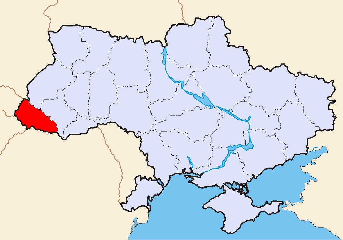
OfficialLang = Ukrainian, Hungariansmallsup|1
Administrative_center =Uzhhorod
Largest_cities =Uzhhorod ,Mukachevo ,Khust ,Berehove ,Vynohradiv
GovernorName = Oleh Havashi
GovernorParty = NU
ChairmanName = Mykhailo Kichkovskyi
ChairmanParty = NU
CouncilSeats = 90
DateEstablished =January 22 ,1946
Raions = 13
CityRaions = 5
Cities = 11
CMTs = 19
Villages = 579
AreaRank = 23rd
TotalArea = 12,777
LandArea = ?
WaterArea = ?
PercentWater = ?
PopulationYear = 2006
Population_rank = 17th
Population = 1,241,887
Density = 98
Population_Growth = ?
SalaryYear = 2006
Salary_rank = 16th
Salary = 1070.45
Salary_Growth =
PostalAbbreviation = 88-90xxx
PostalCodePrefix =List of postal codes#U-Z
ISOCode =
FIPSRegionCode =
PhoneCode = +380-31
LicencePlateNumber = РЕ, АО
Website = www.carpathia.gov.ua
VRSite = [http://gska2.rada.gov.ua:7777/pls/z7502/A005?rdat1=11.11.2006&rf7571=10949 www.rada.gov.ua]
Footnotes = smallsup|1 TheHungarian language has some official rights in 7 villages of the .Zakarpattia Oblast ( _uk. Закарпатська область, translit. transl|uk|"Zakarpats’ka oblast’"; _ry. Подкарпатьска област, translit. transl|ry|"Podkarpat’ska oblast"; _hu. Kárpátontúli terület; _sk. Zakarpatská oblasť; also referred to as the Transcarpathian Oblast, Transcarpathia, Zakarpattya, or historically Subcarpathian Rus) is an administrative oblast (
province ) located in westernUkraine . Its administrative center is the city ofUzhhorod . Other major cities within the oblast includeMukachevo ,Khust ,Berehove and Chop which is home to railroad transport infrastructure.Zakarpattia Oblast was formally established on
January 22 ,1946 after the annexation of Subcarpathian Rus lands to theUkrainian Soviet Socialist Republic . During the Ukrainian independence referendum held in 1991, Zakarpattia Oblast voters were given a separate option on whether or not they favoredautonomy for the region. Although a large majority favored autonomy, it was not granted.Situated in the
Carpathian Mountains landscape of western Ukraine, Zakarpattia Oblast is the only Ukrainian administrative division which borders upon four countries:Poland ,Slovakia ,Hungary , andRomania . The Carpathian Mountains play a major part in the oblast's economy, making the region an important tourist and travel destination housing many ski and spa resorts.The oblast is ranked 23rd by area and 17th by population. According to the 2001 Ukrainian Census, the population of Zakarpattia Oblast is 1,254,614. Excluding
Ukrainians , this total includes people of many different nationalities of whichHungarians ,Romanians andRusyns constitute significant minorities in some of the province's cities, while in others, they form the majority of the population (as in the case of Berehove).Geography
Zakarpattia Oblast has a total area of 12,800 km² and is located in the
Carpathian Mountains region of western Ukraine.cite web|url=http://www.carpathia.gov.ua/ua/29.htm|title=Geography|accessdate=2007-11-18|work=Zakarpattia Oblast Council|language=Ukrainian] It is the only Ukrainian oblast to have boundaries with four countries:Poland ,Slovakia ,Hungary andRomania . On the West it borders the Prešov and Košice Regions ofSlovakia andBorsod-Abaúj-Zemplén andSzabolcs-Szatmár-Bereg Counties ofHungary , on the South—the Satu Mare and Maramureş Counties ofRomania , on the East and Northeast—Ivano-Frankivsk Oblast , and on the North—Lviv Oblast and theSubcarpathian Voivodeship ofPoland .Zakarpattia Oblast mostly consists of mountains and small hills covered with
deciduous and coniferous forests, as well asalpine meadow s. Mountains cover about 80% of the oblast's area, and cross from North-East to South-East.cite web|url=http://all.zakarpattya.net/eng/begin.html|title=Transcarpathia is my region|accessdate=2007-06-01|work=All Zakarpattya] ThePrimeval Beech Forests of the Carpathians , part of which are located within Zakarpattia Oblast, were recognised as aUNESCO World Heritage Site in 2007. [cite web|url=http://whc.unesco.org/en/list/1133|title=Primeval Beech Forests of the Carpathians|accessdate=2007-07-04|work=UNESCO World Heritage Centre]The largest
river s that flow through the oblast include the Tysa, Borzhava, and the Tereblia. The region's climate is moderate and continental with about 700-1000millimetre s of rainfall per year. The average temperature in summer is +21°С (70°F) and -4°С (25°F) in winter.Zakarpattia is one of the most magnificent regions of Ukraine which stand out by its eventful history and unique cultural heritage. High mountainous valleys and Hutzul Alps, castles and wooden churches, Sinevir Lake and the valley of narcissus, the museum of folk architecture of rural life style will ingrain deeply into the memory of every visitor. The four of the oblast's historical-cultural sites were nominated for the
Seven Wonders of Ukraine competition in 2007:Palanok Castle ,Museum upon the Chorna River ,Mykhailiv Orthodox Church , and theNevytsky Castle .With a total height of convert|2061|m|ft|lk=on,
Hoverla , part of theChornohora mountain range, is the tallest point in the oblast. The lowest point, 101 metres abovesea level , is located in the village of Ruski Heyevtsi in theUzhhorodskyi Raion .History
Zakarpattia was part of
Kingdom of Hungary , laterAustria-Hungary until the latter's demise at the end ofWorld War I . This region was briefly part of the short-livedWest Ukrainian National Republic in 1918 and occupied byRomania at end of that year. It was later recaptured byHungary in the summer of 1919. Finally, it joined the newly formedCzechoslovakia as "Subcarpathian Rus", of which it formed one of the four main regions, the others beingBohemia ,Moravia andSlovakia . [cite book|title=Ukraine: A History|author=Subtelny, Orest |publisher=University of Toronto Press |year=2000|id=ISBN 0-8020-8390-0|pages=448]During the
World War II German occupation of Czechoslovakia , the southern part of the region was awarded toHungary under theFirst Vienna Award in 1938. The remaining portion was constituted as an autonomous region of the short-lived Second Czecho-Slovak Republic. After the occupation of Bohemia and Moravia on March 15, 1939 and the Slovak declaration of an independent state, Ruthenia declared its independence (Republic of Carpatho-Ukraine) but it was immediately occupied and later annexed by Hungary. [Subtelny, p. 458]During the German occupation of Hungary in 1944, almost the entire Jewish population was deported; few survived the
Holocaust .cite web|url=http://all.zakarpattya.net/eng/begin.html|title=History of the region|accessdate=2007-06-01|work=All Zakarpattya] When the Soviet Army crossed the pre-1938 borders of Czechoslovakia in 1944, Soviet authorities refused to allow Czechoslovak governmental officials to resume control over the region, and in June 1945, PresidentEdvard Beneš formally signed a treaty ceding the area to theSoviet Union . It was then incorporated into theUkrainian SSR . After the break-up of the Soviet Union, it became part of independent Ukraine as "Zakarpattia Oblast".The province has a unique footnote in history as the only region in the former Soviet Union to have had an American governor: its first governor was
Gregory Zatkovich , an American citizen who had earlier emigrated from the region and represented the Rusyn community in the U.S. Zatkovich was appointed governor by Czechoslovakia's first president,Tomáš Masaryk , in 1920 and served for about one year until he resigned over differences regarding the region's autonomy.After the fall of the Soviet Union in 1991, Ukraine held an independence referendum in which the residents of Zakarpattia were asked about the Zakarpattia Oblast Council's proposal for self rule.cite book |title=Ukraine: An Illustrated History|last=Magocsi|first=Paul Robert|year=2007|publisher=
University of Washington Press |location=Seattle|isbn=0295987235] About 78% of the oblast's population voted in favor of autonomy, however, it was not granted. There were also propositions of separating from Ukraine to rejoinCzechoslovakia , [Subtelny, p. 578] but after Czechoslovakia's dissolution into theCzech Republic andSlovakia onJanuary 1 ,1993 , these ideas have been rendered largely moot.Politics
Zakarpattia Oblast's local administration is controlled by the Zakarpattia Oblast Council ("
rada "). The Chairman of the Council is Mykhailo Kichkovskyi, elected from thePeople's Union "Our Ukraine" party. Kichkovsky holds this position since his election in April 2006.cite news|title=Mikhail Kichkovsky is elected Chairman of the Zakarpattia oblast council|url=http://www.podrobnosti.ua/power/local/2006/04/18/306404.html|work=Podrobnosti |date=April 18 , 2006|accessdate=2008-04-13|language=Russian]The Zakarpattia Oblast Rada consists of a total of 90 deputies. Based on the
March 26 ,2006 regional election results, the distribution of the council's mandates is as follows: 30mandate s for the People's Union "Our Ukraine;" 25 for theYulia Tymoshenko Bloc ; 7 for the Lytvyn People's Bloc; 5 for the Party ofHungarians of Ukraine "KMKS;" 4 for the Democratic Party of Hungarians of Ukraine; and 4 for theSocialist Party of Ukraine .The oblast's
governor (currently Oleh Havashi) is appointed by thePresident of Ukraine .Administrative divisions

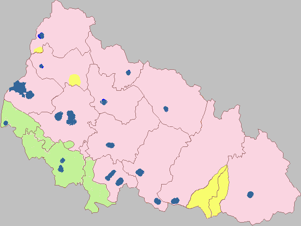
thumb|250px|Historical regions in Zakarpattia Oblast:Zakarpattia Oblast is administratively subdivided into 13
raions (district s), as well as 5 cities (municipalities) which are directly subordinate to the oblast government:Berehove , Chop,Khust ,Mukachevo , and the administrative center of the oblast,Uzhhorod . There are a total of 7 cities, 19 towns, and more than 579 villages.Zakarpattia Oblast can also be divided into four unofficial geographic-historic regions (counties): Ung, Bereg,
Ugocsa , and Northern Maramuresh.The following data incorporates the number of each type of administrative divisions of Zakarpattia Oblast: [cite web|url=http://gska2.rada.gov.ua:7777/pls/z7502/A005?rdat1=11.11.2006&rf7571=10949|title=General info. Zakarpattia Oblast|accessdate=2007-06-03|work=Verkhovna Rada of Ukraine|language=Ukrainian]
* Administrative Center — 1 (
Uzhhorod );
*Raions — 13; [cite web|url=http://gska2.rada.gov.ua:7777/pls/z7502/A004RS?rdat1=11.11.2006&rf7571=10949|title=Zakarpattia Oblast (raions)|accessdate=2007-06-03|work=Verkhovna Rada of Ukraine|language=Ukrainian]
* City raions — 0;
* Settlements — 609, including:
**Villages — 579; [cite web|url=http://gska2.rada.gov.ua:7777/pls/z7502/A004SIL?rdat1=11.11.2006&rf7571=10949|title=Zakarpattia Oblast (villages)|accessdate=2007-06-03|work=Verkhovna Rada of Ukraine|language=Ukrainian]
** Cities/Towns — 30, including:
***Urban-type settlement s — 19; [cite web|url=http://gska2.rada.gov.ua:7777/pls/z7502/A004SMT?rdat1=11.11.2006&rf7571=10949|title=Zakarpattia Oblast (urban-type settlements)|accessdate=2007-06-03|work=Verkhovna Rada of Ukraine|language=Ukrainian]
*** Cities — 11, including:
**** Cities of oblast' subordinance — 5; [cite web|url=http://gska2.rada.gov.ua:7777/pls/z7502/A004MOZ?rdat1=11.11.2006&rf7571=10949|title=Zakarpattia Oblast (cities of oblast' subordinance)|accessdate=2007-06-03|work=Verkhovna Rada of Ukraine|language=Ukrainian]
**** Cities of raion subordinance — 6; [cite web|url=http://gska2.rada.gov.ua:7777/pls/z7502/A004MRZ?rdat1=11.11.2006&rf7571=10949|title=Zakarpattia Oblast (cities of raion subordinance)|accessdate=2007-06-03|work=Verkhovna Rada of Ukraine|language=Ukrainian]
*Selsovet s — 307. [cite web|url=http://gska2.rada.gov.ua:7777/pls/z7502/A004RASIL?rdat1=11.11.2006&rf7571=10949|title=Zakarpattia Oblast (village councils)|accessdate=2007-06-03|work=Verkhovna Rada of Ukraine|language=Ukrainian]Raions
There are 13
raion s (district s) in the oblast:
#Berehivskyi Raion
#Irshavskyi Raion
#Khustskyi Raion
#Mizhhirskyi Raion
#Mukachivskyi Raion
#Perechynskyi Raion
#Rakhivskyi Raion
#Svaliavskyi Raion
#Tiachivskyi Raion
#Uzhhorodskyi Raion
#Velykobereznianskyi Raion
#Volovetskyi Raion
#Vynohradivskyi Raion Cities
Largest cities and towns in the province are (with population figures in 2007): [cite web|url=http://www.world-gazetteer.com/wg.php?x=&men=gcis&lng=en&des=gamelan&dat=200&geo=-220&srt=pnan&col=aohdqcfbeimg&geo=-3740|title= Zakarpatsʿka: largest cities and towns and statistics of their population|accessdate=2007-06-01|work=World Gazetteer]
*Uzhhorod (118,231)
*Mukachevo (81,344)
*Khust (27,506)
*Berehove (25,288)
*Vynohradiv (24,366)
*Svaliava (16,217)
*Rakhiv (14,416)
*Tiachiv (9,256)
*Mizhhiria (9,133)
*Irshava (9,000)
*Velykyy Bychkiv (8,920)
*Solotvyno (8,774)
*Dubove (8,745)
*Velyki Luchky (8,540)
* Chop (8,436)
*Ilnytsia (8,420)
*Bushtyno (8,091)Demographics
[
thumb|250px|Ethnic_map_of_Zakarpattia_Oblast_in_2001.legend|#4682B4|mixed Ukrainians (incl. Rusyns) andRussians ]According to the 2001 Ukrainian Census, the population of Zakarpattia Oblast is 1,254,614.cite web|url=http://ukrcensus.gov.ua/eng/regions/reg_zakar/|title=Regions of Ukraine / Zakarpattia region|accessdate=2007-06-01|work=2001 Ukrainian Census] The current estimated population is 1.2 million people (as of 2004).
Although ethnic
Ukrainians are in majority here (80.5%),cite web|url=http://ukrcensus.gov.ua/eng/results/general/nationality/Zakarpattia/|title=General results of the census / National composition of population / Zakarpattia region|accessdate=2007-06-01|work=2001 Ukrainian Census] otherethnic group s are relatively numerous in Zakarpattia. The largest of these areHungarians (12.1%),Romanians (2.6%),Russians (2.5%), Roma (1.1%),Slovaks (0.5%) andGermans (0.3%). The Ukrainian government does not recognize theRusyn people living in that country as a distinct nationality but rather as an ethnic group of Ukrainians. About 10,100 people (0.8%) identify themselves as Rusyns according to the last census. [cite web|url=http://ukrcensus.gov.ua/results/general/nationality/zakarpatia/|title=General results of the census / National composition of population / Zakarpattia region|accessdate=2007-06-03|work=2001 Ukrainian Census|language=Ukrainian]Their languages and culture are respected by the provision of education, clubs, etc. in their respective languages. Those who recognize Ukrainian as their native language total 81.0% of the population, Hungarian — 12.7%, Russian — 2.9%, Romanian — 2.6%, and Rusyn — 0.5% [cite web|url=http://ukrcensus.gov.ua/regions/select_reg5/?box=5.5W&data1=1&rz=1_1&rz_b=2_1&data=1&botton=cens_db&k_t=00|title=Regions of Ukraine / Results of the census|accessdate=2007-06-03|work=2001 Ukrainian Census|language=Ukrainian] Residents in seven of
Mukachivskyi Raion 's villages have the option to learn the Hungarian language in a school or home school environment.Zakarpattia is home to approximately 14,000 ethnic Roma (otherwise known as Gypsies), the largest population of Roma in Ukraine. The first Hungarian College in Ukraine is in Berehovo, the
II. Rákoczi Ferenc College .Economy
Situated in the
Carpathian Mountains , Zakarpattia Oblast's economy depends mostly on trans-border trade, vinery andforestry . The oblast is also home to aspecial economic zone . [cite web|url=http://all.zakarpattya.net/eng/begin.html|title= History of the Region|accessdate=2007-06-01|work=World Gazetteer] [Cite Ukrainian law|type=Verkhovna Rada law|number=2322-III|law=2322-14|name=On the official economic zone of "Zakarpattia"|date=2004-03-31]The oblast's main industry includes
woodworking . Other industries include food, light industry, and mechanical engineering. Segment of foodstuffs in the structure of ware production of national consumption is 45%. The total number of large industrial organisations is 319, compared to 733 small industrial organisations.cite web|url=http://www.kmu.gov.ua/control/en/publish/article?art_id=117393&cat_id=32596|title=Zakarpattya Region|accessdate=2007-06-01|work=Cabinet of Ministers of Ukraine ]The most common crops grown within the region include
cereal s,potato es and other vegetables. In 1999, the total amount of grain produced was 1,75,800ton s, of sunflower seeds — 13,000 tons, and potatoes — 3,780,200 thousand tons. The region also produced 7,610,000 tons of meat, 3,634,000 tons of milk and 2,41,900 eggs. The total amount of registered farms in the region was 1,400 in 1999.ee also
*
Administrative divisions of Ukraine
*Carpathian Ruthenia , small historical region
*Carpatho-Ukraine , a short-lived Ukrainian state on the territory
* Ruthenians and Ukrainians in Czechoslovakia
* Museum of Folk Architecture and Life, museum displaying Zakarpattia architectureReferences
External links
* [http://www.carpathia.gov.ua/ carpathia.gov.ua] — Official website of Zakarpattia Oblast Administration uk icon/en icon
* [http://gska2.rada.gov.ua:7777/pls/z7502/A005?rdat1=11.11.2006&rf7571=10949 Verkhovna Rada website] — Zakarpattia Oblast data
* [http://48x24.com/home/go?lat=48.62120&lng=22.29710&zoom=13 Photos and infrastructure objects of Zakarpattia on interactive map (Ukrainian Navigational Portal)]
* [http://www.simkovich.org/carpatho-rusyns.carpathorussianhistory.htm Zakarpattia Early & Recent History, and Photos]
* [http://all.zakarpattya.net/eng/begin.html all.zakarpattya.net] — All about Zakarpattia en icon/uk icon
* [http://www.mukachevo.net/ mukachevo.net] — Zakarpattia Oblast informational portal uk icon
* [http://map.meta.ua/?] — Digital map of Zakarpattia Oblast uk icon
* [http://karpaty.prygl.net/ukrajina.php Zakarpattia Oblast - photographs]

Wikimedia Foundation. 2010.