Malpas, Cornwall

Malpas, Cornwall

Coordinates: 50°14′37″N 5°01′39″W / 50.2436°N 5.0276°W / 50.2436; -5.0276

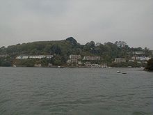
Malpas at the confluence of the Truro and Tresillian rivers

Malpas is a riverside village in Cornwall, United Kingdom. It is situated two miles (3 km) southeast of the city of Truro, on the banks of the Malpas Estuary of the Truro River and Tresillian River.[1]

The village is in the civil parish of St Clement and is a popular centre for boating with navigable waterways to Truro, Falmouth and the sea. Historically, Malpas is known for its ferry service to the Roseland peninsula and there is a myth that this crossing was used by Iseult. Ferries and boat trips still operate from Malpas.[2][3]

References

  1. ^ Ordnance Survey: Landranger map sheet 204 Truro & Falmouth ISBN 978-0-319-23149-4
  2. ^ Cornwall Council website; ferries; Ferry 17. Retrieved April 2010
  3. ^ Enterprise Boats website; services. Retrieved April 2010


Wikimedia Foundation. 2010.

Игры ⚽ Поможем сделать НИР

Look at other dictionaries:

  • Malpas — could be: Places Malpas, Cheshire, England Malpas, Cornwall, England Malpas, Newport, South Wales Malpas, Doubs, a commune in the Doubs department, France Malpas Tunnel, a tunnel on the Canal du Midi People Jeff Malpas, Australian philosopher… …   Wikipedia

  • Cornwall bus routes — This is a list of frequent bus routes operating in the county of Cornwall, England, United Kingdom. The majority of bus services are financially supported by Cornwall County Council. Recently, services operated by Sunset Coaches are now operated… …   Wikipedia

  • St Clement, Cornwall — Coordinates: 50°15′19″N 5°01′04″W / 50.2552°N 5.0178°W / 50.2552; 5.0178 …   Wikipedia

  • List of bus routes in Cornwall — A map which shows the area these services operate in. This is a list of bus routes[1] in Cornwall, England, United Kingdom. The major operators in the Cornwall area are Western Greyhound and First Devon Cornwall. Other operators …   Wikipedia

  • List of places in Cornwall — This is a list of all the towns and villages of Cornwall, United Kingdom. This also includes places in the Isles of Scilly. See List of places in England for lists of settlements in other counties. Top 15 places by population Alphabetical list A… …   Wikipedia

  • Lizard Point, Cornwall — mit den vorgelagerten Felsen Der Lizard Point in Cornwall ist der südlichste Punkt der Lizard Halbinsel und gleichzeitig der südlichste Punkt Englands auf der Hauptinsel Großbritanniens. Er markiert die nördliche Einfahrt in den Ärmelkanal. Die… …   Deutsch Wikipedia

  • List of Sites of Special Scientific Interest in Cornwall — The following is a list of Sites of Special Scientific Interest in Cornwall (including the Isles of Scilly). List of SSSIs by Area of Search.* Aire Point To Carrick Du * Amble Marshes * Annet * Baulk Head To Mullion * Bedruthan Steps And Park… …   Wikipedia

  • River Truro — Coordinates: 50°15′25″N 5°02′42″W / 50.257°N 5.045°W / 50.257; 5.045 …   Wikipedia

  • Chester (district) — City of Chester Motto: Antiqui Colant Antiquum Dierum (Let the Ancients worship the Ancient of Days) Geography …   Wikipedia

  • Clio (barque) — Three masted barque, similar to the Clio The Clio was a three masted barque (1838 1866) built of black birch, pine and oak at Granville, Nova Scotia, (weight: 473 tons). She was registered at St. John s, Newfoundland and Labrador on completion.… …   Wikipedia

Share the article and excerpts

Direct link
Do a right-click on the link above
and select “Copy Link”