- Diep River, Cape Town
-
Diep River — Suburb — Street map of Diep River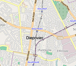
Country  South Africa
Province Western Cape Municipality City of Cape Town Wards Population (2001)[1] - Total 2,710 Ethnic groups - Black African 1.77% - Coloured 14.76% - Indian or Asian 1.44% - White 82.03% Languages - English 91.70% - Afrikaans 7.08% - Xhosa 0.44% Time zone SAST (UTC+2) Postal code 7800, 7945 Diep River is a suburb in Cape Town, South Africa. The suburb is named after the Diep River or Dieprivier in Afrikaans, that runs through the area.
Geography
Diep River is bordered by Heathfield to the south and Plumstead to the north. Diep River railway station is on the main line from Cape Town to Simon's Town.
References
- ^ "Diep River". Census 2001. City of Cape Town. http://www.capetown.gov.za/en/stats/2001census/Documents/Diep%20River.htm. Retrieved 2 July 2010.
Suburbs of Cape Town City Bowl Bo-Kaap · De Waterkant · Gardens · Higgovale · Oranjezicht · Schotsche Kloof · Tamboerskloof · University Estate · Vredehoek · Walmer Estate · Woodstock · ZonnebloemNorthern Suburbs Bellville · Bothasig · Brackenfell · Brooklyn · Durbanville · Edgemead · Elsie's River · Facreton · Goodwood · Kensington · Kuils River · Maitland · Monte Vista · Panorama · Parow · ThorntonAtlantic Seaboard Bantry Bay · Camps Bay · Clifton · Fresnaye · Green Point · Hout Bay · Llandudno · Mouille Point · Sea Point · Three Anchor BaySouthern Suburbs Bergvliet · Bishopscourt · Claremont · Constantia · Diep River · Heathfield · Kenilworth · Mowbray · Newlands · Observatory · Pinelands · Plumstead · Retreat · Rondebosch · Rondebosch East · Rosebank · Salt River · Steenberg · Tokai · WynbergSouth Peninsula Capri Village · Clovelly · Fish Hoek · Glencairn · Kalk Bay · Kommetjie · Masiphumelele · Muizenberg · Noordhoek · Ocean View · Scarborough · Simon's Town · St James · Sunnydale · Sun ValleyCape Flats Athlone · Belhar · Blue Downs · Bonteheuwel · Crawford · Crossroads · Delft · Elsie's River · Epping · Grassy Park · Gugulethu · Khayelitsha · Langa · Lansdowne · Lotus River · Manenberg · Mfuleni · Mitchell's Plain · Nyanga · Ottery · Philippi · WettonFalse Bay West Coast Coordinates: 34°02′03″S 18°27′52″E / 34.03417°S 18.46444°E
Categories:- South Africa geography stubs
- Suburbs of Cape Town
- Western Cape geography stubs

Wikimedia Foundation. 2010.