- Observatory, Cape Town
-
Observatory — Suburb — Top: The historic observatory building at the SAAO headquarters after which the area is named. Middle left: Groote Schuur Hospital. Centre Middle: A monument in the centre of the Neighborhood. Middle right: Cafes on lower main road in Observatory. Bottom: A view of Observatory's soccer and hockey stadium looking towards Devil's Peak.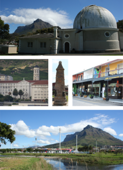 Map of Observatory, from OpenStreetMap.
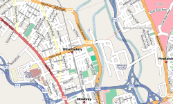 Location of Observatory in Cape Town
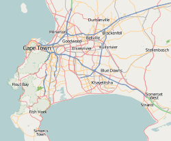
 Observatory
Coordinates: 33°56′16″S 18°28′15″E / 33.93778°S 18.47083°ECoordinates: 33°56′16″S 18°28′15″E / 33.93778°S 18.47083°E Country  South Africa
Province Western Cape Municipality City of Cape Town Wards 57 Government[1] - Councillor Cedric Thomas (DA) Population (2001)[2] - Total 5,310 Ethnic groups - Black African 20.28% - Coloured 18.78% - Indian or Asian 3.50% - White 57.42% Languages - English 71.09% - Afrikaans 15.37% - Xhosa 6.65% Time zone SAST (UTC+2) Postal code 7925 Observatory is a suburb in Cape Town, South Africa, bordered by Mowbray to the south, and Salt River to the north. The area is best known as student neighborhood, most of whom attend the University of Cape Town located close by, and for being the home of the South African Astronomical Observatory headquarters as well as Groote Schuur Hospital.[3]
Contents
Geography and history
Much of present-day Observatory was a marshy estuary formed by the rivers, with buffalo, hippo, elephant, zebra,jackals, antelope, lions and leopards once prevalent[citation needed].
Observatory traces its origins to the Koornhoop Colony land grant, in 1657. Officials from the Dutch East India Company were given land in the Liesbeeck River valley, and Jan van Riebeek himself had a farm there, originally called Uitwyk, later Malta Farm.[4]
The name is derived from the location of the first Royal Observatory in the area at 33°56′7.13″S 18°28′38.47″E / 33.9353139°S 18.4773528°E in 1820. This original site serves as the headquarters of the South African Astronomical Observatory, with an on-site museum exhibiting various historic instruments and telescopes.
During the years of apartheid, Observatory was one of the few de facto 'grey' suburbs where all races lived together. It continues to be a somewhat alternative part of town, with 'New Age' style shops and a monthly 'Holistic Fair' at the Community Centre on the first Sunday of each month. It is served by Observatory railway station on the Southern Line, with regular trains every 40 minutes or so, every hour on Sunday.
Observatory is the location for much of the short-term accommodation used by increasing numbers of overseas, particularly North American and European, students attending UCT[citation needed].
Economy and popular culture
Observatory has long had a vibrant entertainment scene, perhaps as a result of its high proportion of students.[original research?] There are numerous restaurants and bars, with a high turnover, but some long term stayers. Most restaurants and retail shops are located along Lower Main road. There is also a shopping complex in St. Peter's square, which is located opposite Groote Schuur graveyard.
Known locally as 'Obs', its proximity to the University of Cape Town (UCT) and its Medical School in particular, have always made it popular with students and lecturers.
Observatory has many churches. The Anglican parish church of St Michael and All Angels, designed by Sir Herbert Baker and the only one of his churches completed to his design, has a strong choral tradition.
Observatory has a soccer and hockey stadium below the station, Hartleyvale, on Liesbeeck Parkway and an outdoor swimming pool that's very popular on summer afternoons - between the two there's a circus school. A driving range and nine hole golf course is housed at the River Club. In November 2009 the Observatory Improvement District was launched to enhance the suburb with better security and cleansing. In 2010, walking and cycle paths were established on the western side of the Liesbeek River. There are two birdwatching hides on the river, one in the grounds of the South African Observatory, and one in the grounds of the River Club.
Hospitals
Beyond the astronomical observatory is Valkenberg psychiatric hospital, a Victorian building that has recently undergone extensive renovations. Valkenberg houses the mentally ill in secure accommodation as well as providing out patient care. Beyond Valkenberg is a small hotel, and the Wild Fig restaurant.
'Obs' also harbours the Groote Schuur Hospital, where Professor Chris Barnard performed the world's first heart transplant, on 3 December 1967. The hospital's emergency department is off the N2 motorway and, consequently, serves the crime-ridden and poor suburbs on the Cape Flats.
Crime and security
As with most of Cape Town, crime has been a problem in recent years, with burglary, and muggings as well as minor vandalism and graffiti. Over the past decade there have been several murders. A pioneering community security organisation, Obs Watch, ran bicycle patrols for years, but became defunct as a result of a strange quirk of company law[citation needed]. It has been replaced by the Observatory Neighbourhood Watch[citation needed]. Large CCTV cameras have been erected at most of the exits and entrances to Obs.
References
- ^ "Cape Town city Councillors by ward". City of Cape Town. http://web1.capetown.gov.za/web1/newcitycouncil/councilsearch.asp. Retrieved 25 September 2010.
- ^ "Observatory". Census 2001. City of Cape Town. http://www.capetown.gov.za/en/stats/2001census/Documents/Observatory.htm. Retrieved 25 September 2010.
- ^ "Cape Town - Southern Suburbs". Maps Info South Africa. http://capetownmap.blogspot.com/p/2-southern-suburbs.html. Retrieved 25 September 2010.
- ^ "The History of Observatory". 2008-05-31. Archived from the original on 2008-06-23. http://web.archive.org/web/20080623010728/http://obz.org.za/content/oca/history-observatory. Retrieved 2008-08-17.
External links
Suburbs of Cape Town City Bowl Bo-Kaap · De Waterkant · Gardens · Higgovale · Oranjezicht · Schotsche Kloof · Tamboerskloof · University Estate · Vredehoek · Walmer Estate · Woodstock · ZonnebloemNorthern Suburbs Bellville · Bothasig · Brackenfell · Brooklyn · Durbanville · Edgemead · Elsie's River · Facreton · Goodwood · Kensington · Kuils River · Maitland · Monte Vista · Panorama · Parow · ThorntonAtlantic Seaboard Bantry Bay · Camps Bay · Clifton · Fresnaye · Green Point · Hout Bay · Llandudno · Mouille Point · Sea Point · Three Anchor BaySouthern Suburbs Bergvliet · Bishopscourt · Claremont · Constantia · Diep River · Heathfield · Kenilworth · Mowbray · Newlands · Observatory · Pinelands · Plumstead · Retreat · Rondebosch · Rondebosch East · Rosebank · Salt River · Steenberg · Tokai · WynbergSouth Peninsula Capri Village · Clovelly · Fish Hoek · Glencairn · Kalk Bay · Kommetjie · Masiphumelele · Muizenberg · Noordhoek · Ocean View · Scarborough · Simon's Town · St James · Sunnydale · Sun ValleyCape Flats Athlone · Belhar · Blue Downs · Bonteheuwel · Crawford · Crossroads · Delft · Elsie's River · Epping · Grassy Park · Gugulethu · Khayelitsha · Langa · Lansdowne · Lotus River · Manenberg · Mfuleni · Mitchell's Plain · Nyanga · Ottery · Philippi · WettonFalse Bay West Coast Categories:- Suburbs of Cape Town


Wikimedia Foundation. 2010.