- Mowbray, Cape Town
-
Mowbray — Suburb — Mostert's Mill, February 2008 Street map of Mowbray
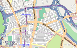 Location in the Cape Town metropolitan area
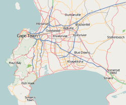
 Mowbray
Coordinates: 33°56′46″S 18°28′34″E / 33.94611°S 18.47611°ECoordinates: 33°56′46″S 18°28′34″E / 33.94611°S 18.47611°E Country  South Africa
Province Western Cape Municipality City of Cape Town Population (2001)[1] - Total 4,367 Time zone SAST (UTC+2) Postal code 7700 Mowbray is one of the Southern Suburbs of Cape Town, South Africa. Its original name was Driekoppen (In Dutch, "Three heads").
Contents
Geography
Mowbray is bounded on the west by the M3 freeway, beyond which lies Devil's Peak, and on the north by the N2 freeway, beyond which lies the suburb of Observatory. Towards the east, the built-up area of Mowbray ends at the M5 freeway, beyond which lies the Black River and the suburb of Pinelands; however, the official boundaries of Mowbray also include the Rondebosch and Mowbray golf courses, which lie beyond the M5, towards Sybrand Park and Pinelands respectively. On the south, Mowbray borders on the suburb of Rosebank with a less well-defined boundary.
The Liesbeeck River flows from south to north through Mowbray, and separates the suburb into two distinct sections. The western section lies on the lower slopes of Devil's Peak, and contains most of the commercial development in the suburb. The eastern section, known as "Little Mowbray", lies on the low hill between the Liesbeeck and Black Rivers.
The well-known Quaker Peace Centre has its offices in Mowbray.
Transport
Mowbray is well-connected to the road network, being bounded (as described above) by the M3, M5 and N2 freeways. Apart from the freeways, the main roads in the suburb are Main Road (M4) and Liesbeeck Parkway (M57), which run north-south; Victoria Road/St. Peter's Road/Durban Road/Klipfontein Road (M18) which runs west-east; and Raapenberg Road (M52) which runs to the north-east towards Pinelands.
For public transport, Mowbray is served by a station on the Metrorail Southern Suburbs railway line. Next to the station is a large Golden Arrow bus station with routes running out all over Cape Town, and a minibus taxi rank.
Windmill
Main article: Mostert's MillThe only complete windmill in South Africa is Mostert's Mill. It was built in 1796 and worked until the 1860s. It was restored in 1935 and again in 1995 and is open to the public one Saturday a month.
References
- ^ "Mowbray". Census 2001. City of Cape Town. http://www.capetown.gov.za/en/stats/2001census/Documents/Mowbray.htm. Retrieved 5 February 2010.
Suburbs of Cape Town City Bowl Bo-Kaap · De Waterkant · Gardens · Higgovale · Oranjezicht · Schotsche Kloof · Tamboerskloof · University Estate · Vredehoek · Walmer Estate · Woodstock · ZonnebloemNorthern Suburbs Bellville · Bothasig · Brackenfell · Brooklyn · Durbanville · Edgemead · Elsie's River · Facreton · Goodwood · Kensington · Kuils River · Maitland · Monte Vista · Panorama · Parow · ThorntonAtlantic Seaboard Bantry Bay · Camps Bay · Clifton · Fresnaye · Green Point · Hout Bay · Llandudno · Mouille Point · Sea Point · Three Anchor BaySouthern Suburbs Bergvliet · Bishopscourt · Claremont · Constantia · Diep River · Heathfield · Kenilworth · Mowbray · Newlands · Observatory · Pinelands · Plumstead · Retreat · Rondebosch · Rondebosch East · Rosebank · Salt River · Steenberg · Tokai · WynbergSouth Peninsula Capri Village · Clovelly · Fish Hoek · Glencairn · Kalk Bay · Kommetjie · Masiphumelele · Muizenberg · Noordhoek · Ocean View · Scarborough · Simon's Town · St James · Sunnydale · Sun ValleyCape Flats Athlone · Belhar · Blue Downs · Bonteheuwel · Crawford · Crossroads · Delft · Elsie's River · Epping · Grassy Park · Gugulethu · Khayelitsha · Langa · Lansdowne · Lotus River · Manenberg · Mfuleni · Mitchell's Plain · Nyanga · Ottery · Philippi · WettonFalse Bay West Coast Categories:- Suburbs of Cape Town


Wikimedia Foundation. 2010.